
Saline County, Missouri facts for kids
Quick facts for kids
Saline County
|
|
|---|---|

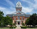
The Saline County Courthouse in Marshall
|
|

Location within the U.S. state of Missouri
|
|
 Missouri's location within the U.S. |
|
| Country | |
| State | |
| Founded | November 25, 1820 |
| Named for | The salt springs in the region |
| Seat | Marshall |
| Largest city | Marshall |
| Area | |
| • Total | 767 sq mi (1,990 km2) |
| • Land | 756 sq mi (1,960 km2) |
| • Water | 11 sq mi (30 km2) 1.5% |
| Population
(2020)
|
|
| • Total | 23,333 |
| • Density | 30.421/sq mi (11.746/km2) |
| Time zone | UTC−6 (Central) |
| • Summer (DST) | UTC−5 (CDT) |
| Congressional district | 4th |
Saline County is a county in the state of Missouri. It is located along the Missouri River. In 2020, about 23,333 people lived there.
The main town, or county seat, is Marshall. The county was started on November 25, 1820. It got its name from the many salt springs in the area.
Many people from states like Kentucky and Virginia moved here in the 1800s. They brought enslaved people with them. These enslaved people were forced to work on large farms. Because of this, Saline County was part of a region called "Little Dixie." Before the American Civil War, about one-third of the people living here were African American.
Saline County is also part of the Marshall, Missouri area, which is a smaller city area.
Contents
History of Saline County
For thousands of years, different groups of Native Americans lived in the area that is now Saline County. These included the Osage nation.
European-American settlers officially formed Saline County on November 25, 1820. It was named for the salty springs found there. Over time, as more settlers arrived, there were conflicts with the Native Americans. The U.S. government eventually made the local Native Americans move to special lands called reservations.
Many early settlers came from southern states like Kentucky, Tennessee, and Virginia. They grew crops like hemp and tobacco. These crops needed a lot of workers. So, the settlers brought enslaved people with them or bought them. These counties, settled by southerners, became known as "Little Dixie."
By the time of the American Civil War, about one-third of the county's population was African American. Most of them were enslaved workers on big farms. In 1847, a state law made it hard for African Americans to get an education.
After the Civil War, many people, especially formerly enslaved people, really wanted to learn. Missouri's new constitution created public schools for everyone. However, schools were separate for different races, which was common back then. Schools for Black students in the countryside often didn't get enough money or resources.
By the early 1900s, Saline County had eighteen schools for Black students. Today, many of these old schools from the Jim Crow era are being studied. They are being recognized as important historical places.
Geography
Saline County covers about 767 square miles. About 756 square miles are land, and 11 square miles are water. The Missouri River forms its northern border. The Grand River also joins the Missouri River here.
Neighboring Counties
- Carroll County (northwest)
- Chariton County (northeast)
- Howard County (east)
- Cooper County (southeast)
- Pettis County (south)
- Lafayette County (west)
Main Roads
 Interstate 70
 U.S. Route 40
 U.S. Route 65
 Route 20
 Route 41
 Route 127
 Route 240
Protected Areas
- Big Muddy National Fish and Wildlife Refuge (part of it is in Saline County)
Population Changes
The county's population was highest in 1930. Since then, it has slowly gone down. This is partly because new machines meant fewer farm workers were needed. Also, from about 1910 to the 1970s, many African Americans moved to bigger cities for jobs and better living conditions.
| Historical population | |||
|---|---|---|---|
| Census | Pop. | %± | |
| 1830 | 2,873 | — | |
| 1840 | 5,258 | 83.0% | |
| 1850 | 8,843 | 68.2% | |
| 1860 | 14,699 | 66.2% | |
| 1870 | 21,672 | 47.4% | |
| 1880 | 29,911 | 38.0% | |
| 1890 | 33,762 | 12.9% | |
| 1900 | 33,703 | −0.2% | |
| 1910 | 29,448 | −12.6% | |
| 1920 | 28,817 | −2.1% | |
| 1930 | 30,598 | 6.2% | |
| 1940 | 29,416 | −3.9% | |
| 1950 | 26,694 | −9.3% | |
| 1960 | 25,148 | −5.8% | |
| 1970 | 24,633 | −2.0% | |
| 1980 | 24,919 | 1.2% | |
| 1990 | 23,523 | −5.6% | |
| 2000 | 23,756 | 1.0% | |
| 2010 | 23,370 | −1.6% | |
| 2020 | 23,333 | −0.2% | |
| U.S. Decennial Census 1790-1960 1900-1990 1990-2000 2010 |
|||
In 2000, there were 23,756 people living in Saline County. About 90% of the people were White. About 5.4% were Black or African American. Other groups included Native American, Asian, and Pacific Islander people. About 4.4% of the population was Hispanic or Latino.
The average age of people in the county was 37 years old. About 24% of the population was under 18.
Education
Saline County has several schools and school districts.
Public Schools
Here are some of the public school districts in the county:
- Glasgow School District
- Malta Bend R-V School District – Malta Bend
- Malta Bend Elementary School (Grades PK-5)
- Malta Bend High School (Grades 6-12)
- Marshall School District – Marshall
- Eastwood Elementary School (Grades PK-3)
- Benton Elementary School (Grades K-1)
- Northwest Elementary School (Grades K-4)
- Southeast Elementary School (Grades K-2)
- Bueker Middle School (Grades 5-8)
- Marshall High School (Grades 9-12)
- Pettis County R-V School District
- Santa Fe R-X School District
- Slater Public Schools – Slater
- Slater Elementary School (Grades PK-8)
- Slater High School (Grades 9-12)
- Sweet Springs R-VII School District – Sweet Springs
- Sweet Springs Elementary School (Grades PK-6)
- Sweet Springs High School (Grades 7-12)
Some districts only have elementary schools:
- Blackwater R-II School District
- Gilliam C-4 School District – Gilliam
- Gilliam Elementary School (Grades K-8)
- Hardeman R-X School District – Marshall
- Hardeman Elementary School (Grades PK-8)
- Miami R-I School District
- Orearville R-IV School District – Orearville (uses Slater postal address)
- Orearville Elementary School (Grades K-8)
Private Schools
Colleges
- Missouri Valley College – Marshall – This is a private, four-year university.
Public Libraries
- Marshall Public Library
- Slater Public Library
- Sweet Springs Public Library
Towns and Villages
Cities
- Blackburn
- Emma
- Malta Bend
- Marshall (county seat)
- Miami
- Nelson
- Slater
- Sweet Springs
Villages
Other Communities
Images for kids
-
The Saline County Courthouse in Marshall
See also
 In Spanish: Condado de Saline (Misuri) para niños
