Howard County, Missouri facts for kids
Quick facts for kids
Howard County
|
|
|---|---|

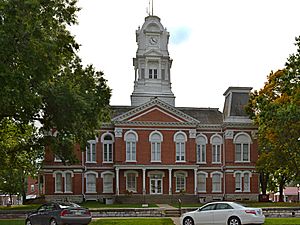
Howard County Courthouse in Fayette
|
|
| Nickname(s):
Mother of Counties
|
|

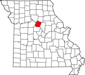
Location within the U.S. state of Missouri
|
|
 Missouri's location within the U.S. |
|
| Country | |
| State | |
| Founded | January 23, 1816 |
| Named for | Benjamin Howard |
| Seat | Fayette |
| Largest city | Fayette |
| Area | |
| • Total | 472 sq mi (1,220 km2) |
| • Land | 464 sq mi (1,200 km2) |
| • Water | 7.7 sq mi (20 km2) 1.6% |
| Population
(2020)
|
|
| • Total | 10,151 |
| • Density | 21.506/sq mi (8.304/km2) |
| Time zone | UTC−6 (Central) |
| • Summer (DST) | UTC−5 (CDT) |
| Congressional district | 4th |
Howard County is a county in the U.S. state of Missouri. Its southern edge is along the Missouri River. In 2020, about 10,151 people lived there. The main town and county seat (where the county government is) is Fayette.
The county was created on January 23, 1816. It was named after Benjamin Howard, who was an officer in the United States Army. He was also the first Governor of the Missouri Territory from 1809 to 1813. This was after the United States bought a huge area of land called the Louisiana Purchase from France in 1803. The Missouri Territory was a large part of this new land.
Howard County is part of a region known as Little Dixie. It is also part of the larger Columbia, Missouri, metropolitan area.
Contents
History of Howard County
Howard County is on the north side of the Missouri River. Many of its first settlers came from southern states like Kentucky, Tennessee, and Virginia. These settlers often brought enslaved people with them. They grew crops like hemp and tobacco using this labor.
Because of this, by 1860, about 25% of the county's population were enslaved African Americans. During the American Civil War, many people in Howard County supported the Confederacy. After the war, laws called "Jim Crow laws" created segregation (separation of races) in the county.
Over time, farming became more modern with machines. This meant fewer people were needed to work on farms. So, many people moved away to cities to find jobs. Today, Howard County is still mostly rural. About one-third of the people living there now have German family backgrounds.
Geography
The U.S. Census Bureau says that Howard County covers about 472 square miles. Most of this (464 square miles) is land, and a small part (7.7 square miles) is water.
Neighboring Counties
- Chariton County (northwest)
- Randolph County (northeast)
- Boone County (southeast)
- Cooper County (south)
- Saline County (west)
Main Roads
- U.S. Route 40
- Route 3
- Route 5
- Route 87
- Route 124
- Route 240
Protected Areas
- Big Muddy National Fish and Wildlife Refuge (part of it is in the county)
Population Information
| Historical population | |||
|---|---|---|---|
| Census | Pop. | %± | |
| 1820 | 13,426 | — | |
| 1830 | 10,854 | −19.2% | |
| 1840 | 13,108 | 20.8% | |
| 1850 | 13,969 | 6.6% | |
| 1860 | 15,946 | 14.2% | |
| 1870 | 17,233 | 8.1% | |
| 1880 | 18,428 | 6.9% | |
| 1890 | 17,371 | −5.7% | |
| 1900 | 18,337 | 5.6% | |
| 1910 | 15,653 | −14.6% | |
| 1920 | 13,997 | −10.6% | |
| 1930 | 13,490 | −3.6% | |
| 1940 | 13,026 | −3.4% | |
| 1950 | 11,857 | −9.0% | |
| 1960 | 10,859 | −8.4% | |
| 1970 | 10,561 | −2.7% | |
| 1980 | 10,008 | −5.2% | |
| 1990 | 9,631 | −3.8% | |
| 2000 | 10,212 | 6.0% | |
| 2010 | 10,144 | −0.7% | |
| 2020 | 10,151 | 0.1% | |
| U.S. Decennial Census 1790-1960 1900-1990 1990-2000 2010-2015 |
|||
In 2000, there were 10,212 people living in Howard County. The population was spread out, with about 24% of people under 18 years old. The average age was 37 years.
Most people in the county (about 91%) were White. About 7% were Black or African American. Many people also reported having German, American, English, or Irish family backgrounds.
The average income for a family in the county was about $40,167 per year. About 11.6% of the population lived below the poverty line.
2020 Census
| Race | Num. | Perc. |
|---|---|---|
| White (NH) | 8,826 | 87% |
| Black or African American (NH) | 542 | 5.34% |
| Native American (NH) | 34 | 0.33% |
| Asian (NH) | 27 | 0.26% |
| Pacific Islander (NH) | 3 | 0.03% |
| Other/Mixed (NH) | 511 | 5% |
| Hispanic or Latino | 208 | 2.05% |
Education
Howard County has several schools and a university.
Public Schools
- Fayette R-III School District (in Fayette)
- Laurence J. Daly Elementary School (Grades PK-5)
- William N. Clark Middle School (Grades 6-8)
- Fayette High School (Grades 9-12)
- Glasgow School District (in Glasgow)
- Howard County Elementary School (Grades PK-6)
- Glasgow High School (Grades 7-12)
- Harrisburg R-VIII School District
- Higbee R-VIII School District
- New Franklin R-I School District (in New Franklin)
- New Franklin Elementary School (Grades PK-5)
- New Franklin Middle/High School (Grades 6-12)
- Salisbury R-IV School District
Private Schools
- St. Mary's Catholic School (in Glasgow) – for grades K-8, part of the Roman Catholic faith.
Colleges and Universities
- Central Methodist University (in Fayette) – a private, four-year university.
Public Libraries
- Howard County Library
- Lewis Library of Glasgow
Communities
Cities and Towns
- Armstrong
- Fayette (county seat)
- Franklin
- Glasgow
- New Franklin
Small Communities (Unincorporated)
Notable People
- Frank P. Briggs – a former United States Senator.
- Sara Evans – a famous American country music singer.
- Spottswood Rice – a soldier in the Civil War and a church minister.
- Talbot Smith – a United States District Judge.
- Kit Carson – a famous trapper and guide.
- Caius T. Ryland – a former Speaker of the California State Assembly.
See also
 In Spanish: Condado de Howard (Misuri) para niños
 | DeHart Hubbard |
 | Wilma Rudolph |
 | Jesse Owens |
 | Jackie Joyner-Kersee |
 | Major Taylor |

