Cooper County, Missouri facts for kids
Quick facts for kids
Cooper County
|
|
|---|---|

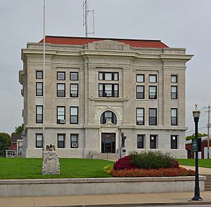
Cooper County Courthouse in Boonville
|
|

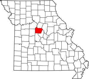
Location within the U.S. state of Missouri
|
|
 Missouri's location within the U.S. |
|
| Country | |
| State | |
| Founded | December 17, 1818 |
| Named for | Sarshell Cooper |
| Seat | Boonville |
| Largest city | Boonville |
| Area | |
| • Total | 569 sq mi (1,470 km2) |
| • Land | 565 sq mi (1,460 km2) |
| • Water | 4.4 sq mi (11 km2) 0.8% |
| Population
(2020)
|
|
| • Total | 17,103 |
| • Density | 30.058/sq mi (11.605/km2) |
| Time zone | UTC−6 (Central) |
| • Summer (DST) | UTC−5 (CDT) |
| Congressional district | 4th |
Cooper County is a county in the central part of Missouri, a state in the United States. In 2020, about 17,103 people lived here. The main town, or county seat, is Boonville.
The county was started on December 17, 1818. It was named after Sarshell Cooper, an early settler who faced dangers on the frontier in 1814 near Arrow Rock. Cooper County is also part of the larger Columbia, Missouri metropolitan area, which means it's connected to the nearby city of Columbia.
Contents
Exploring Cooper County's Geography
Cooper County covers a total area of about 569 square miles. Most of this area, about 565 square miles, is land. The remaining 4.4 square miles, or 0.8%, is water.
Neighboring Counties
Cooper County shares its borders with several other counties:
- Howard County (to the north)
- Boone County (to the northeast)
- Moniteau County (to the southeast)
- Morgan County (to the south)
- Pettis County (to the west)
- Saline County (to the northwest)
Main Roads and Highways
Major roads help people travel through Cooper County and connect it to other places.
 Interstate 70
 U.S. Route 40
 Route 5
 Route 41
 Route 87
 Route 98
 Route 135
 Route 179
Special Protected Areas
- Big Muddy National Fish and Wildlife Refuge is a protected area in the county. It helps keep nature safe for animals and plants.
People and Population in Cooper County
The number of people living in Cooper County has changed over many years.
| Historical population | |||
|---|---|---|---|
| Census | Pop. | %± | |
| 1820 | 6,959 | — | |
| 1830 | 6,904 | −0.8% | |
| 1840 | 10,484 | 51.9% | |
| 1850 | 12,950 | 23.5% | |
| 1860 | 17,356 | 34.0% | |
| 1870 | 20,692 | 19.2% | |
| 1880 | 21,596 | 4.4% | |
| 1890 | 22,707 | 5.1% | |
| 1900 | 22,532 | −0.8% | |
| 1910 | 20,311 | −9.9% | |
| 1920 | 19,308 | −4.9% | |
| 1930 | 19,522 | 1.1% | |
| 1940 | 18,075 | −7.4% | |
| 1950 | 16,608 | −8.1% | |
| 1960 | 15,448 | −7.0% | |
| 1970 | 14,732 | −4.6% | |
| 1980 | 14,643 | −0.6% | |
| 1990 | 14,835 | 1.3% | |
| 2000 | 16,670 | 12.4% | |
| 2010 | 17,601 | 5.6% | |
| 2020 | 17,103 | −2.8% | |
| U.S. Decennial Census 1790-1960 1900-1990 1990-2000 2010-2015 |
|||
In 2000, there were 16,670 people living in Cooper County. Most people were White (89.05%), and about 8.96% were Black or African American. A small number of people were Native American, Asian, or Pacific Islander. About 0.86% of the population was Hispanic or Latino.
Many families lived in the county, with 31.80% of households having children under 18. The average age of people in Cooper County was 35 years old.
2020 Population Details
The 2020 census showed more details about the people in Cooper County:
| Race | Num. | Perc. |
|---|---|---|
| White (not Hispanic) | 14,730 | 86.13% |
| Black or African American (not Hispanic) | 920 | 5.4% |
| Native American (not Hispanic) | 53 | 0.31% |
| Asian (not Hispanic) | 67 | 0.4% |
| Pacific Islander (not Hispanic) | 6 | 0.04% |
| Other/Mixed (not Hispanic) | 1,005 | 6% |
| Hispanic or Latino | 322 | 2% |
Learning and Schools in Cooper County
Cooper County has several schools where kids can learn and grow.
Public Schools
There are many public school districts in the county:
- Blackwater R-II School District
- Blackwater Elementary School (Grades PK-8)
- Boonville R-I School District
- Hannah Cole Primary School (Grades PK-2)
- David Barton Elementary School (Grades 3-5)
- Laura Speed Elliott Middle School (Grades 6-8)
- Boonville High School (Grades 9-12)
- Bunceton (Cooper County R-IV School District)
- Bunceton Elementary School (Grades K-6)
- Bunceton High School (Grades 7-12)
- Otterville R-VI School District
- Otterville Elementary School (Grades K-6)
- Otterville High School (Grades 7-12)
- Pilot Grove C-4 School District
- Pilot Grove Elementary School (Grades PK-5)
- Pilot Grove Middle School (Grades 6-8)
- Pilot Grove High School (Grades 9-12)
- Prairie Home R-V School District
- Prairie Home Elementary School (Grades K-6)
- Prairie Home High School (Grades 7-12)
Private Schools
There are also private schools in Cooper County:
- Boonville: Saints Peter & Paul School (Grades K-9), a Roman Catholic school.
- Bunceton: Zion Lutheran School (Grades 2-8), a Lutheran school.
- Pilot Grove: St. Joseph Elementary School (Grades 2-9), also a Roman Catholic school.
Public Libraries
- The Boonville/Cooper Branch Library is a great place to find books and learn.
Towns and Areas in Cooper County
Cooper County has several towns and smaller communities.
Cities
- Blackwater
- Boonville (This is the county seat, the main town for county government)
- Bunceton
- Otterville
- Pilot Grove
- Prairie Home
Villages
Smaller Communities (Unincorporated)
These are smaller areas that are not officially cities or villages.
Townships
Cooper County is divided into 14 areas called townships. These help organize the county.
- Blackwater
- Boonville
- Clark Fork
- Clear Creek
- Kelly
- Lamine
- Lebanon
- North Moniteau
- Otterville
- Palestine
- Pilot Grove
- Prairie Home
- Saline
- South Moniteau
Famous People from Cooper County
- Country music singer Sara Evans was born in Cooper County.
See also
 In Spanish: Condado de Cooper (Misuri) para niños
 | Frances Mary Albrier |
 | Whitney Young |
 | Muhammad Ali |

