Boone County, Missouri facts for kids
Quick facts for kids
Boone County
|
||
|---|---|---|

|
||
|
||

Location within the U.S. state of Missouri
|
||
 Missouri's location within the U.S. |
||
| Country | ||
| State | ||
| Founded | November 16, 1820 | |
| Named for | Daniel Boone (1734-1820) | |
| Seat | ||
| Largest city | ||
| Area | ||
| • Total | 691 sq mi (1,790 km2) | |
| • Land | 685 sq mi (1,770 km2) | |
| • Water | 5.6 sq mi (15 km2) 0.8% | |
| Population
(2020)
|
||
| • Total | 183,610 | |
| • Density | 265.72/sq mi (102.59/km2) | |
| Time zone | UTC−6 (Central) | |
| • Summer (DST) | UTC−5 (CDT) | |
| Congressional district | 4th | |
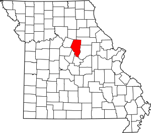
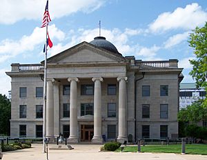
Boone County is a county in the state of Missouri, United States. It's located right in the middle of Missouri, in a region called Mid-Missouri. The main city and county seat is Columbia. Columbia is also Missouri's fourth-largest city and home to the University of Missouri.
In 2020, about 183,610 people lived in Boone County. This makes it the eighth most populated county in Missouri. The county was created on November 16, 1820. It was named after the famous explorer and pioneer, Daniel Boone. His family helped settle this area, arriving in the 1810s.
Boone County is part of the Columbia Metropolitan Area. The towns of Ashland and Centralia are the next biggest towns after Columbia.
Contents
History
Boone County was officially formed on November 16, 1820. It was created from a part of the much larger Howard County. This central part of Missouri is sometimes called Boonslick or Boone's Lick Country. This name comes from a nearby salt spring, or "lick." Daniel Boone's sons, Daniel Morgan Boone and Nathan Boone, used this spring for their animals.

Many early settlers in Boone County came from states like Kentucky, Tennessee, and Virginia. They brought with them the practice of owning slaves. They quickly started growing crops like hemp and tobacco, similar to what was grown in Kentucky. Boone County was one of several counties along the Missouri River settled by people from the Southern United States. Because of its culture, this area became known as Little Dixie. Boone County was a very important part of this region. In 1860, about 25% of the county's population were slaves. During the American Civil War (1861-1865), Boone County strongly supported the Confederacy.
After President Abraham Lincoln was assassinated in April 1865, the leaders of Boone County and Columbia spoke out against the killing. They ordered that all public buildings, including the courthouse and the state university, be decorated in black to show sadness for thirty days.
Geography
Boone County covers a total area of 691 square miles. About 685 square miles is land, and 5.6 square miles (0.8%) is water. The Missouri River forms the southern border of the county.
National protected areas
Neighboring counties
- Audrain County (to the northeast)
- Callaway County (to the east)
- Cole County (to the south)
- Cooper County (to the west)
- Howard County (to the northwest)
- Moniteau County (to the southwest)
- Randolph County (to the north)
Main roads
 Interstate 70
 Interstate 70 Business Loop
 U.S. Route 40
 U.S. Route 63
 Route 22
 Route 124
 Route 163
Demographics
| Historical population | |||
|---|---|---|---|
| Census | Pop. | %± | |
| 1820 | 3,692 | — | |
| 1830 | 8,859 | 140.0% | |
| 1840 | 13,561 | 53.1% | |
| 1850 | 14,979 | 10.5% | |
| 1860 | 19,486 | 30.1% | |
| 1870 | 20,765 | 6.6% | |
| 1880 | 25,422 | 22.4% | |
| 1890 | 26,043 | 2.4% | |
| 1900 | 28,642 | 10.0% | |
| 1910 | 30,533 | 6.6% | |
| 1920 | 29,672 | −2.8% | |
| 1930 | 30,995 | 4.5% | |
| 1940 | 34,991 | 12.9% | |
| 1950 | 48,432 | 38.4% | |
| 1960 | 55,202 | 14.0% | |
| 1970 | 80,911 | 46.6% | |
| 1980 | 100,376 | 24.1% | |
| 1990 | 112,379 | 12.0% | |
| 2000 | 135,454 | 20.5% | |
| 2010 | 162,642 | 20.1% | |
| 2020 | 183,610 | 12.9% | |
| U.S. Decennial Census 1790–1960 1900–1990 1990–2000 2010–2020 |
|||
In 2000, there were 135,454 people living in Boone County. The population density was about 198 people per square mile. Most people (85.43%) were White. About 8.54% were Black or African American, and 2.96% were Asian. About 1.78% of the population was Hispanic or Latino. Many people reported their background as German (24.6%), American (12.3%), English (11.2%), and Irish (9.8%).
The median age in the county was 30 years old. This means half the people were younger than 30 and half were older. For every 100 females, there were about 93.5 males.
The median income for a household was $37,485. For a family, it was $51,210. About 14.5% of the population lived below the poverty line.
As of 2022, there are 127,433 registered voters in Boone County.
Religion
Boone County is sometimes seen as being on the northern edge of the "Bible Belt." This means that Protestantism is a very common religion here. The largest religious groups in Boone County are Baptists (20.81%), especially from the Southern Baptist Convention. Roman Catholics make up 16.71% of religious followers. There are also many smaller nondenominational Christian groups (13.23%).
2020 Census
| Race | Num. | Perc. |
|---|---|---|
| White (NH) | 137,771 | 75% |
| Black or African American (NH) | 17,882 | 9.7% |
| Native American (NH) | 452 | 0.3% |
| Asian (NH) | 7,772 | 4.23% |
| Pacific Islander (NH) | 120 | 0.07% |
| Other/Mixed (NH) | 11,561 | 6.3% |
| Hispanic or Latino | 8,052 | 4.4% |
Education
Public schools
- Southern Boone (Ashland) R-I School District
- Centralia R-VI School District – Centralia
- Columbia School District No. 93 – Columbia
- Hallsville R-IV School District – Hallsville
- Harrisburg R-VIII School District – Harrisburg
- Sturgeon R-V School District – Sturgeon
Private schools
- Apple School – Columbia (PK-K)
- Children's House And Windsor Street Montessori – Columbia (PK-06)
- Christian Chapel Academy – Columbia (K-08)
- Christian Fellowship School – Columbia (PK-12)
- College Park Christian Academy – Columbia (K-09)
- Our Lady of Lourdes Interparish School– Columbia (K-08)
- Columbia Independent School – Columbia (PK-12)
- Father Tolton Regional High School- Columbia (09-12)
- Good Shepherd Lutheran School – Columbia (K-08)
- Islamic School of Columbia, Missouri – Columbia (K-05)
- Shalom Christian Academy – Columbia (PK-12)
- Sunnydale Adventist Academy – Centralia (09-12)
Colleges and Universities
- University of Missouri at Columbia: A large public university, started in 1839.
- Columbia College – Columbia: A private university, founded in 1851.
- Stephens College – (Columbia): A private university for women, founded in 1833.
- Moberly Area Community College (MACC): A two-year public college with a campus in Columbia.
Public libraries
- Centralia Public Library
- Daniel Boone Regional Library
- Southern Boone County Public Library
- Holts Summit Public Library
- Columbia Public Library
Communities
Cities
Villages
Unincorporated communities
Townships
Townships are smaller areas within the county. Their borders have changed over time.
- Bourbon
- Cedar
- Centralia
- Columbia
- Katy
- Missouri
- Perche
- Rock Bridge
- Rocky Fork
- Three Creeks
Notable people
- James William Abert – soldier and explorer
- Simon Barrett – filmmaker
- Rob Benedict – actor
- John William Boone – musician
- Jessica Capshaw – actress
- Albert Bishop Chance – inventor and mayor of Centralia
- J'den Cox – wrestler, Olympic medalist
- Kevin Croom – UFC Mixed Martial Artist
- Derek "Deke" Dickerson – musician
- Carl Edwards – retired NASCAR driver
- Jane Froman – singer and actress
- Nicole Galloway – former Missouri State Auditor
- William Least Heat-Moon – writer
- Martin Heinrich – U.S. Senator from New Mexico
- Peter Hessler – journalist
- Brett James – singer
- William Jewell – educator and former mayor of Columbia
- Tyler Johnson – baseball pitcher
- E. Stanley Kroenke – sports team owner
- Ken Lay – former chief executive of Enron
- Jeff Maggert – professional golfer
- John Neihardt – poet
- Don Nardo – author
- Carlos Pena Jr. – singer
- Michael Porter Jr. – basketball player for the Denver Nuggets
- James S. Rollins – 19th-century politician
- Charles Griffith Ross – press secretary for U.S. President Harry S. Truman
- Felix Sabates – philanthropist
- Jon Scott – television journalist
- Clay Shirky – writer
- William Smith – actor
- Blake Tekotte – baseball player
- Malcolm Thomas – professional basketball player
- Nischelle Turner – television personality
- Charlie Van Dyke – radio personality
- Andrew VanWyngarden – musician
- James "Bud" Walton – co-founder of Wal-Mart
- Sam Walton – co-founder of Wal-Mart
- Norbert Wiener – mathematician
- Lisa Wilcox – actress
- Roger B. Wilson – former Governor of Missouri
See also
 In Spanish: Condado de Boone (Misuri) para niños
 | James Van Der Zee |
 | Alma Thomas |
 | Ellis Wilson |
 | Margaret Taylor-Burroughs |


