Sturgeon, Missouri facts for kids
Quick facts for kids
Sturgeon, Missouri
|
|
|---|---|
| City of Sturgeon | |

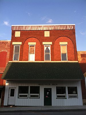
Sturgeon Masonic Lodge
|
|

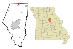
Location of Sturgeon, Missouri
|
|
| Country | United States |
| State | Missouri |
| County | Boone |
| Founded | 1856 |
| Area | |
| • Total | 0.87 sq mi (2.25 km2) |
| • Land | 0.87 sq mi (2.25 km2) |
| • Water | 0.00 sq mi (0.00 km2) |
| Elevation | 850 ft (260 m) |
| Population
(2020)
|
|
| • Total | 907 |
| • Density | 1,042.53/sq mi (402.46/km2) |
| Time zone | UTC-6 (Central (CST)) |
| • Summer (DST) | UTC-5 (CDT) |
| ZIP code |
65284
|
| Area code(s) | 573 |
| FIPS code | 29-71224 |
| GNIS feature ID | 2395992 |
Sturgeon is a city located in Boone County, Missouri, United States. It is part of the larger Columbia Metropolitan Area. In 2010, about 872 people lived there.
Contents
History of Sturgeon
Sturgeon was first planned out in 1856. It grew to include the nearby town of Prairie City. The town officially became a city in 1859. Housen Canada was its first mayor.
The city was named after Isaac H. Sturgeon. He was a superintendent for the North Missouri Railroad. Some people believe the train station was built in Sturgeon because of his name. Six citizens paid a lot of money to make sure the deal happened.
Early Buildings and Businesses
The first school in Sturgeon was built in 1857. By 1882, the schools had many students. The first church was the Methodist Episcopal Church South, built in 1859. A Masonic lodge was located above the church.
An early business was a broom factory, started in 1878 by S. A. Fretwell. The factory made brooms from broom corn grown nearby. They also made brushes from imported jute. In 1882, the factory made about 360 brooms every day.
Natural Events
In the spring of 1857, a tornado hit the town. It blew down several houses. This included a new, three-story hotel building.
The first big fire happened on July 19, 1882. It started in a saloon and quickly spread. Several businesses burned down. The Sturgeon Savings Bank was saved by covering its roof with wet carpets and salt.
The Amish Community
In the fall of 1953, the first Amish family moved north of Sturgeon. Today, this community has grown to over sixty families. Most of the Sturgeon Amish are "Old Order Amish." This means they follow strict rules. They focus on being self-sufficient, helping others, and being independent. The Amish in Sturgeon and Clark run many successful home businesses. They sell things like sorghum, eggs, chicken, peanut brittle, and fresh produce.
Geography of Sturgeon
Sturgeon is located near the northern edge of Boone County. It is about two miles east of U.S. Route 63. The city is also along Missouri Route CC.
The United States Census Bureau says that Sturgeon covers an area of about 0.78 square miles (2.02 square kilometers). All of this area is land.
Population and People
| Historical population | |||
|---|---|---|---|
| Census | Pop. | %± | |
| 1880 | 656 | — | |
| 1890 | 713 | 8.7% | |
| 1900 | 708 | −0.7% | |
| 1910 | 663 | −6.4% | |
| 1920 | 728 | 9.8% | |
| 1930 | 600 | −17.6% | |
| 1940 | 571 | −4.8% | |
| 1950 | 544 | −4.7% | |
| 1960 | 619 | 13.8% | |
| 1970 | 787 | 27.1% | |
| 1980 | 901 | 14.5% | |
| 1990 | 838 | −7.0% | |
| 2000 | 944 | 12.6% | |
| 2010 | 872 | −7.6% | |
| 2020 | 907 | 4.0% | |
| U.S. Decennial Census | |||
2010 Census Information
In 2010, there were 872 people living in Sturgeon. These people lived in 361 households. About 244 of these were families. The city had about 1,118 people per square mile.
Most of the people living in Sturgeon were White (96.8%). A small number were African American, Native American, or Asian. About 1.0% of the population was Hispanic or Latino.
About 30.5% of households had children under 18. Nearly half (49.6%) were married couples. The average household had 2.38 people. The average family had 2.84 people.
The average age in Sturgeon was 39.7 years. About 23.4% of residents were under 18. About 15.8% were 65 or older. The city had slightly more females (54.6%) than males (45.4%).
See also
 In Spanish: Sturgeon (Misuri) para niños
 | Anna J. Cooper |
 | Mary McLeod Bethune |
 | Lillie Mae Bradford |

