
Boonslick facts for kids
The Boonslick, also known as Boone's Lick Country, is a special area in Missouri located along the Missouri River. It was very important in the early 1800s when the United States was expanding westward. This region also played a big part in Missouri becoming a state.
The Boone's Lick Road was a main path for settlers moving west. It followed the north side of the Missouri River, connecting St. Charles to Franklin, Missouri. This road was used by many pioneers traveling from St. Louis. When the road ended in Franklin, it marked the start of the famous Santa Fe Trail. This trail became a major route for trade with Spanish areas in the Southwestern United States. Later, it connected to other big trails like the Oregon and California Trails. These trails were used by pioneers, gold-seekers, and other early settlers heading to the West.
The Boonslick region gets its name from a "salt spring" or "lick." This special spring is in western Howard County. It was used by Nathan and Daniel Morgan Boone, who were the sons of the famous frontiersman Daniel Boone.

What is the Boonslick Region?
Many important early leaders of Missouri came from the Boonslick area. At first, the region had influences from French and Spanish colonial times. However, it was soon settled by European-American migrants. These settlers mostly came from the Upland South, including places like Kentucky, Virginia, and Tennessee. They also brought many enslaved African-Americans with them. These enslaved people were forced to work and helped develop the region.
The exact borders of the Boonslick region can change depending on how it's defined. But it usually includes these counties today:
Before and after the American Civil War, this area became the center of a larger region. This larger region is known as Little Dixie.
Early Towns and Trade Routes
Franklin, Missouri was founded in 1816. It quickly grew into a big port on the Missouri River. It became an important center for settlement and business activity. The Boone's Lick Trail ended here. From Franklin, William Becknell created the Santa Fe Trail heading west. Before this, the Chouteau brothers from St. Louis had a special agreement. They had a monopoly on the fur trade with the Spanish in Santa Fe. This fur trade was how St. Louis first became wealthy.
Columbia, Missouri is the largest city in the Boonslick region today. It is home to the main campus of the University of Missouri system. This university was started in 1839. The famous painter George Caleb Bingham lived and painted in both Franklin and Columbia. His paintings show what pioneer and river life was like in the early and mid-1800s.
Other important early towns in the region included:
In 1827, the original town of Franklin was destroyed by powerful floods from the Missouri River. The town was rebuilt on a higher bluff and named New Franklin. The Smithton Company also established a small village called Smithton, Missouri. This village later grew into the city of Columbia.
Boonslick Today
In the 21st century, the Boonslick area is mostly rural. This means it has a lot of countryside and farms. The city of Columbia is the main exception, being a larger urban area. The region is next to the Missouri Rhineland, which is known for its vineyards. The Boonslick also has its own developed vineyards.
The Katy Trail State Park runs along the Missouri River. This park was created by turning old railroad lines into trails. It's a great place for biking and walking, offering fun outdoor activities.
Images for kids
-
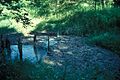
The salt spring known as Boone's Lick in Howard County, Missouri

