
Katy Trail State Park facts for kids
Quick facts for kids Katy Trail |
|
|---|---|

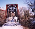
The trail as seen from the Highway 364 overpass in Saint Charles
|
|
| Length | 237.7 mi (382.5 km) |
| Location | Missouri, United States |
| Trailheads | Machens, Missouri Clinton, Missouri |
| Use | Hiking, Cycling, Horseback |
| Elevation change | negligible |
| Highest point | Windsor, Missouri |
| Lowest point | St. Charles, Missouri |
| Difficulty | Easy |
| Season | All |
| Sights | Missouri River, Manitou bluffs |
| Hazards | Severe weather Poison ivy Snakes |
| Trail map | |

The Katy Trail (red) and the Missouri River (blue) on a map of Missouri
|
|
The Katy Trail State Park is a special state park in Missouri, United States. It's home to the Katy Trail, which is the longest recreational rail trail in the country! A rail trail is a path built on an old railroad line.
This amazing trail is about 240 miles (386 km) long. It mostly follows the northern bank of the Missouri River. The trail uses the old path of the Missouri–Kansas–Texas Railroad. The Katy Trail is open all year, from sunrise to sunset. It's a great place for hikers, joggers, and cyclists. The path is made of crushed limestone, which makes it flat and easy to use.
The name "Katy" comes from how people said "KT," which was a short way to say the railroad's name, MKT. Parts of the Katy Trail are also part of two other big trails: the Lewis and Clark National Historic Trail and the American Discovery Trail.
Contents
The Katy Trail's Story: How It Began
The idea of turning old railroad lines into trails became possible because of a law called the National Trails System Act from 1968. In 1982, the city of Columbia opened the MKT Trail. This was one of the first projects in the U.S. to turn an abandoned railroad spur into a trail.
From Railroad to Trail: A Big Flood Changes Everything
On October 4, 1986, a huge flood from the Missouri River badly damaged the railroad tracks. These tracks belonged to the Missouri–Kansas–Texas Railroad and ran from Sedalia to Machens, Missouri. The tracks had been damaged by floods many times before. But this time, the railroad decided not to fix them. The trains were sent on different routes, and the old tracks were left behind.
The Missouri Department of Natural Resources bought this abandoned railroad path. They were able to do this thanks to a generous gift from Edward D. "Ted" Jones and Pat Jones. In 1990, the very first part of the Katy Trail officially opened in Rocheport.
Growing the Trail: More Sections Open
In 1991, another railroad company, the Union Pacific Railroad, gave 33 miles (53 km) of their old railroad path. This section went from Sedalia to Clinton.
The trail was supposed to be finished by 1994. However, a massive flood in 1993, known as the Great Flood of 1993, damaged 75 miles (121 km) of the trail. This caused delays. The section from St. Charles to Sedalia finally opened in 1996. The last part, from Sedalia to Clinton, opened in 1999. In 2011, the trail was made even longer, adding the path from St. Charles to Machens.
Connecting Trails: The Katy Trail Network
The Katy Trail is part of a growing network of trails.
The Rock Island Spur: A New Connection
A new section of trail opened in December 2016. This part uses an old Rock Island railroad path. It's called the Rock Island Spur. This spur starts at Windsor, where it connects to the Katy Trail. It then goes 47 miles (76 km) northwest towards Kansas City.
This new trail extends the system to the suburbs of Kansas City. It reaches Pleasant Hill. This was made possible by an agreement between Missouri Governor Matt Blunt and a company called Ameren. This agreement helped make up for damage caused by a flood at Johnson's Shut-Ins State Park.
Future Plans: Even More Trails
People are working to extend the Rock Island Trail even further into the Kansas City area. A 6-mile (9.7 km) part of this trail opened in the Lee's Summit area in 2019.
There are also plans to add another 144 miles (232 km) of unused railroad path to the Rock Island Trail State Park. If this happens, the Katy Trail and the Rock Island Trail would create a huge 450-mile (724 km) trail network!
This extension would run from Windsor to Beaufort, which is near Washington. The idea is to then extend the trail into Washington. From there, it could cross the Missouri River and connect back to the Katy Trail. This would create a giant loop across the state!
There's also a bigger idea called the "quad state" proposal. This would connect the Katy Trail and other existing trails in Missouri, Kansas, Iowa, and Nebraska.
Where Does the Katy Trail Go?
The Katy Trail starts at Machens (mile-marker 27) right by the Missouri River. It follows the northern bank of the river for most of its journey.
The next big city along the trail is Jefferson City, which is the state capital. At mile-marker 169.9 (McBaine), the Katy Trail connects with the MKT Trail. The MKT Trail leads into downtown Columbia, which is the biggest city along the Katy Trail.
The Katy Trail then leaves its original path and crosses the Missouri River at Boonville. It uses the Boonslick Bridge instead of the old MKT Bridge. From Boonville, the trail continues to its end point in Clinton at mile-marker 264.6.
| City | Mile-marker | Coordinates |
|---|---|---|
| Machens | 27 | 38°54′13″N 90°19′53″W / 38.9035°N 90.3314°W |
| St. Charles | 39 | 38°46′45″N 90°28′52″W / 38.7793°N 90.4811°W |
| Weldon Spring | 55 | 38°39′36″N 90°44′40″W / 38.6600°N 90.7444°W |
| Defiance | 59 | 38°37′48″N 90°46′46″W / 38.6300°N 90.7794°W |
| Matson | 60.6 | 38°36′31″N 90°47′41″W / 38.6087°N 90.7948°W |
| Augusta | 66 | 38°34′11″N 90°52′51″W / 38.5698°N 90.8808°W |
| Hermann | 100 | 38°44′02″N 91°26′41″W / 38.7339°N 91.4447°W |
| Bluffton | 111 | 38°42′20″N 91°37′27″W / 38.7056°N 91.6241°W |
| Jefferson City | 143 | 38°36′21″N 92°09′44″W / 38.6059°N 92.1623°W |
| Hartsburg | 153 | 38°41′39″N 92°18′36″W / 38.6943°N 92.3099°W |
| Columbia | 169.9 (via MKT Trail) | 38°57′02″N 92°19′59″W / 38.9506°N 92.3331°W |
| Rocheport | 179 | 38°58′39″N 92°33′40″W / 38.9776°N 92.5612°W |
| Boonville | 192 | 38°58′30″N 92°44′59″W / 38.9749°N 92.7497°W |
| Sedalia | 227 | 38°42′28″N 93°13′14″W / 38.7078°N 93.2206°W |
| Windsor | 248 | 38°32′08″N 93°31′30″W / 38.5356°N 93.5250°W |
| Clinton | 265 | 38°23′04″N 93°45′28″W / 38.3845°N 93.7578°W |
Important Issues: The Boonville Bridge
The Katy Trail is part of something called "railbanking." This means that the trail must stay connected to the national railway system. This way, if needed, it could be turned back into an active railway.
The Bridge's Role and Future
The part of the trail between St. Charles and Sedalia used to have two connections to the railway system. One was in St. Charles. The other was the Missouri–Kansas–Texas Bridge at Boonville. The Missouri Department of Natural Resources (MDNR) had the right to keep this bridge and use it for the trail.
However, in 2005, the MDNR changed this agreement. They gave up their rights to the bridge. This allowed Union Pacific Railroad to remove the bridge. This created two separate parts of the trail: one east of Boonville and one west. If the connection in St. Charles were ever lost, the trail section between St. Charles and Boonville might lose its "railbanked" status. This could mean the land would go back to its original owners. The same could happen to the section east of Boonville if its connection was lost.
A Happy Ending for the Bridge
On February 4, 2010, Missouri Governor Jay Nixon announced good news! The Union Pacific Railroad decided to give the bridge to the city of Boonville. This ended a disagreement that had lasted almost six years. The city announced that it would fix up the bridge and make it part of the Katy Trail again.
Images for kids
-
Cyclists crossing an old railroad bridge over the Femme Osage Creek near Defiance

