Washington, Missouri facts for kids
Quick facts for kids
Washington, Missouri
|
||
|---|---|---|

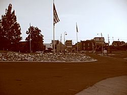
Downtown Washington at dusk, as seen from its Missouri River dock and park
|
||
|
||
| Nickname(s):
Pipe City
|
||

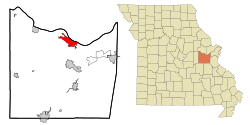
Location of Washington, Missouri
|
||
| Country | United States | |
| State | Missouri | |
| County | Franklin | |
| Named for | George Washington | |
| Area | ||
| • Total | 10.16 sq mi (26.32 km2) | |
| • Land | 9.66 sq mi (25.02 km2) | |
| • Water | 0.50 sq mi (1.30 km2) | |
| Elevation | 558 ft (170 m) | |
| Population
(2020)
|
||
| • Total | 14,500 | |
| • Estimate
(July 1, 2022)
|
15,075 | |
| • Density | 1,500.88/sq mi (579.50/km2) | |
| Time zone | UTC-6 (Central (CST)) | |
| • Summer (DST) | UTC-5 (CDT) | |
| ZIP code |
63090
|
|
| Area code(s) | 636 | |
| FIPS code | 29-77416 | |
| GNIS feature ID | 2397208 | |
Washington is a city in Missouri, located on the south bank of the Missouri River. It is about 50 miles west of St. Louis, Missouri. With around 15,075 people, it is the largest city in Franklin County, Missouri. Washington is famous for being the "corncob pipe capital of the world." The company Missouri Meerschaum, which makes these pipes, is located right on the city's riverfront.
Contents
History of Washington, Missouri
The city of Washington is named after George Washington. It was first settled when the Spanish Empire ruled the area. Back then, it was called St. John Meyer's Settlement. It was also the site of a Spanish log fort called San Juan del Misuri from 1796 to 1803.
In 1799, the family and followers of Daniel Boone began settling across the river from Washington. By 1814, a ferry boat was licensed to cross the Missouri River to the north. Because of this, the settlement became known as Washington Landing. In 1827, the town was planned out, and land sales began in 1829. To encourage people to move there, the cost of land was waived if buyers built a good house within two years. This helped many new settlers come to the area.
Starting in 1833, many German families who were against slavery moved to Washington. They soon became a larger group than the existing slave owners. However, many of the original homes of slave owners can still be seen in the town. During the American Civil War, Washington strongly supported the Union. Confederate General Sterling Price's soldiers attacked the town, but they could not keep control of the area.
After the war, Washington became an important center for railroad and steamboat transportation. While its manufacturing industry is still strong, it is not as big as it was many years ago.
Washington has 445 buildings listed on the National Register of Historic Places. Because of its historic charm, more and more visitors come to Washington. People are also drawn to the nearby Missouri Rhineland, which is known for its wineries.
The Washington Bridge was built in 1934. For a long time, it was the only bridge crossing the Missouri River in Franklin County. A new, wider bridge opened on December 3, 2018, replacing the old one. The original bridge was taken down on April 13, 2019.
In 1988, the very first Walmart Supercenter in the United States opened in Washington.
Geography and Climate
According to the United States Census Bureau, Washington covers about 9.87 square miles (25.56 square kilometers). Most of this area, about 9.34 square miles (24.19 square kilometers), is land, and 0.53 square miles (1.37 square kilometers) is water.
Most of the rain in Washington falls during the humid spring and summer months. Fall and winter are usually drier. While snow does fall, it is not as common as in the upper Midwest. On average, about 19 inches of snow falls each year.
Weather in Washington
Here is some information about the weather in Washington, Missouri:
| Climate data for Washington, Missouri, 1991–2020 normals, extremes 2009–present | |||||||||||||
|---|---|---|---|---|---|---|---|---|---|---|---|---|---|
| Month | Jan | Feb | Mar | Apr | May | Jun | Jul | Aug | Sep | Oct | Nov | Dec | Year |
| Record high °F (°C) | 73 (23) |
81 (27) |
86 (30) |
91 (33) |
95 (35) |
107 (42) |
105 (41) |
103 (39) |
100 (38) |
92 (33) |
85 (29) |
76 (24) |
107 (42) |
| Mean daily maximum °F (°C) | 39.9 (4.4) |
45.4 (7.4) |
55.8 (13.2) |
67.3 (19.6) |
75.8 (24.3) |
83.8 (28.8) |
88.3 (31.3) |
86.9 (30.5) |
79.5 (26.4) |
68.9 (20.5) |
55.3 (12.9) |
44.5 (6.9) |
66.0 (18.9) |
| Daily mean °F (°C) | 30.1 (−1.1) |
34.4 (1.3) |
44.0 (6.7) |
55.1 (12.8) |
65.0 (18.3) |
73.7 (23.2) |
77.6 (25.3) |
75.9 (24.4) |
67.7 (19.8) |
56.3 (13.5) |
44.0 (6.7) |
34.4 (1.3) |
54.9 (12.7) |
| Mean daily minimum °F (°C) | 20.2 (−6.6) |
23.4 (−4.8) |
32.1 (0.1) |
42.8 (6.0) |
54.2 (12.3) |
63.6 (17.6) |
67.0 (19.4) |
64.9 (18.3) |
55.9 (13.3) |
43.6 (6.4) |
32.8 (0.4) |
24.3 (−4.3) |
43.7 (6.5) |
| Record low °F (°C) | −21 (−29) |
−11 (−24) |
1 (−17) |
24 (−4) |
34 (1) |
46 (8) |
51 (11) |
51 (11) |
36 (2) |
23 (−5) |
10 (−12) |
−7 (−22) |
−21 (−29) |
| Average precipitation inches (mm) | 2.52 (64) |
2.52 (64) |
3.66 (93) |
4.57 (116) |
5.30 (135) |
4.20 (107) |
4.19 (106) |
3.75 (95) |
3.71 (94) |
3.37 (86) |
3.67 (93) |
2.64 (67) |
44.10 (1,120) |
| Average snowfall inches (cm) | 2.6 (6.6) |
1.4 (3.6) |
0.7 (1.8) |
0.1 (0.25) |
0.0 (0.0) |
0.0 (0.0) |
0.0 (0.0) |
0.0 (0.0) |
0.0 (0.0) |
0.0 (0.0) |
0.4 (1.0) |
2.7 (6.9) |
7.9 (20.15) |
| Average precipitation days (≥ 0.01 in) | 7.8 | 8.1 | 10.8 | 11.0 | 12.5 | 10.1 | 8.3 | 7.9 | 7.5 | 8.7 | 8.4 | 8.0 | 109.1 |
| Average snowy days (≥ 0.1 in) | 1.8 | 1.4 | 0.4 | 0.0 | 0.0 | 0.0 | 0.0 | 0.0 | 0.0 | 0.0 | 0.3 | 1.4 | 5.3 |
| Source 1: NOAA | |||||||||||||
| Source 2: National Weather Service | |||||||||||||
Population and People
| Historical population | |||
|---|---|---|---|
| Census | Pop. | %± | |
| 1880 | 2,421 | — | |
| 1890 | 2,725 | 12.6% | |
| 1900 | 3,015 | 10.6% | |
| 1910 | 3,670 | 21.7% | |
| 1920 | 3,132 | −14.7% | |
| 1930 | 5,918 | 89.0% | |
| 1940 | 6,756 | 14.2% | |
| 1950 | 6,850 | 1.4% | |
| 1960 | 7,961 | 16.2% | |
| 1970 | 8,499 | 6.8% | |
| 1980 | 9,251 | 8.8% | |
| 1990 | 10,704 | 15.7% | |
| 2000 | 13,243 | 23.7% | |
| 2010 | 13,982 | 5.6% | |
| 2020 | 14,500 | 3.7% | |
| U.S. Decennial Census | |||
Washington's Population in 2020
The 2020 United States census found that 14,500 people lived in Washington. There were 5,785 households and 3,766 families. Most of the people, about 92.21%, were white. Other groups included black or African-American (0.61%), Native American (0.22%), Asian (0.79%), and Pacific Islander (0.12%). About 1.7% of the population was Hispanic or Latino.
About 22.7% of the population was under 18 years old. The average age in the city was 38.6 years.
Washington's Population in 2010
In the census of 2010, there were 13,982 people living in Washington. About 96.7% of the people were White. Other groups included African American (0.7%), Native American (0.1%), and Asian (0.5%). About 2.1% of the population was Hispanic or Latino.
About 24.1% of the people were under 18 years old. The average age was 39.4 years.
Education in Washington
The School District of Washington runs the public schools in the city. Washington High School is the main high school for the area.
There are also several private schools in Washington:
- St. Francis Borgia Regional High School
- St. Francis Borgia Grade School (for students from pre-kindergarten to 8th grade)
- Our Lady of Lourdes Grade School (for students from pre-kindergarten to 8th grade)
- Immanuel Lutheran School (for students from pre-kindergarten to 8th grade)
Washington has a public library that is part of the Scenic Regional Library system.
Sister City
Since 1990, Washington has had a sister city relationship with Marbach am Neckar in Germany. Students and people from both cities sometimes visit each other as part of this program.
Famous People from Washington
- Matt Pickens, a former professional soccer player
- Jack Wagner, an American actor known for his roles on TV
See also
 In Spanish: Washington (Misuri) para niños
 | Georgia Louise Harris Brown |
 | Julian Abele |
 | Norma Merrick Sklarek |
 | William Sidney Pittman |


