Weldon Spring, Missouri facts for kids
Quick facts for kids
Weldon Spring, Missouri
|
|
|---|---|

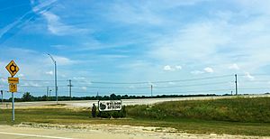
Welcome sign to Weldon Spring, Missouri in June 2018
|
|

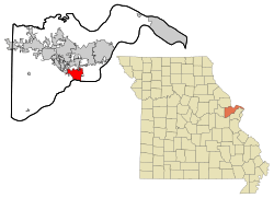
Location of Weldon Spring, Missouri
|
|
| Country | United States |
| State | Missouri |
| County | St. Charles |
| Area | |
| • Total | 7.78 sq mi (20.14 km2) |
| • Land | 7.65 sq mi (19.81 km2) |
| • Water | 0.13 sq mi (0.33 km2) |
| Elevation | 541 ft (165 m) |
| Population
(2020)
|
|
| • Total | 5,326 |
| • Density | 696.48/sq mi (268.91/km2) |
| Time zone | UTC-6 (Central (CST)) |
| • Summer (DST) | UTC-5 (CDT) |
| FIPS code | 29-78314 |
| GNIS feature ID | 0756882 |
Weldon Spring is a city located in St. Charles County, Missouri, in the United States. In 2020, about 5,326 people lived there. It is a quiet place with an interesting past.
Contents
A Look Back at Weldon Spring
Weldon Spring was officially planned out in 1864. The community got its name from a natural spring nearby. A post office opened in Weldon Spring in 1875 and stayed open until 1957.
Wartime Factories
In 1941, the United States Army bought a large area of land around Weldon Spring. They built a huge factory called the Weldon Spring Ordnance Works. This factory was the biggest explosives plant in the United States. It made materials like TNT for the Allied forces during World War II. The factory closed on August 15, 1945, soon after the war ended. Most of the land was then sold.
After the war, in 1945, there was an idea to put the United Nations Headquarters in this area.
Uranium Plant and Cleanup
In 1955, the United States Atomic Energy Commission built a different kind of factory. This one processed uranium ore. The Weldon Spring Uranium Feed Mill Plant made a material called "yellow cake uranium ore." This plant closed in 1966 and was left empty for 20 years.
The site became contaminated with a lot of materials, including radioactive uranium. The U.S. Department of Energy started a big cleanup project in the late 1980s. They finished the cleanup in 2001. Now, there is a large, safe mound of covered material on the site.
Where is Weldon Spring?
Weldon Spring is located about 27 miles west-northwest of St. Louis.
According to the United States Census Bureau, the city covers a total area of 7.64 square miles (19.79 km2). Most of this area, 7.51 square miles (19.45 km2), is land. The rest, 0.13 square miles (0.34 km2), is water.
Weldon Spring's Climate
| Climate data for Weldon Spring, Missouri (1991–2020 normals, extremes 1957–present) | |||||||||||||
|---|---|---|---|---|---|---|---|---|---|---|---|---|---|
| Month | Jan | Feb | Mar | Apr | May | Jun | Jul | Aug | Sep | Oct | Nov | Dec | Year |
| Record high °F (°C) | 76 (24) |
85 (29) |
88 (31) |
94 (34) |
93 (34) |
106 (41) |
107 (42) |
109 (43) |
102 (39) |
95 (35) |
85 (29) |
76 (24) |
109 (43) |
| Mean daily maximum °F (°C) | 39.3 (4.1) |
44.8 (7.1) |
55.2 (12.9) |
67.0 (19.4) |
75.7 (24.3) |
83.7 (28.7) |
87.5 (30.8) |
86.7 (30.4) |
79.8 (26.6) |
68.3 (20.2) |
55.4 (13.0) |
44.0 (6.7) |
65.6 (18.7) |
| Daily mean °F (°C) | 30.3 (−0.9) |
34.6 (1.4) |
44.2 (6.8) |
55.4 (13.0) |
65.0 (18.3) |
73.5 (23.1) |
77.4 (25.2) |
76.0 (24.4) |
68.4 (20.2) |
56.9 (13.8) |
45.2 (7.3) |
35.0 (1.7) |
55.2 (12.9) |
| Mean daily minimum °F (°C) | 21.2 (−6.0) |
24.4 (−4.2) |
33.3 (0.7) |
43.8 (6.6) |
54.2 (12.3) |
63.3 (17.4) |
67.3 (19.6) |
65.4 (18.6) |
57.0 (13.9) |
45.6 (7.6) |
34.9 (1.6) |
25.9 (−3.4) |
44.7 (7.1) |
| Record low °F (°C) | −23 (−31) |
−14 (−26) |
−11 (−24) |
18 (−8) |
26 (−3) |
39 (4) |
43 (6) |
36 (2) |
22 (−6) |
19 (−7) |
0 (−18) |
−28 (−33) |
−28 (−33) |
| Average precipitation inches (mm) | 2.61 (66) |
2.43 (62) |
3.74 (95) |
4.70 (119) |
5.09 (129) |
4.72 (120) |
3.92 (100) |
3.58 (91) |
3.50 (89) |
3.37 (86) |
3.69 (94) |
3.07 (78) |
44.42 (1,128) |
| Average snowfall inches (cm) | 4.1 (10) |
3.7 (9.4) |
1.7 (4.3) |
0.2 (0.51) |
0.0 (0.0) |
0.0 (0.0) |
0.0 (0.0) |
0.0 (0.0) |
0.0 (0.0) |
0.0 (0.0) |
0.8 (2.0) |
3.0 (7.6) |
13.5 (34) |
| Average precipitation days (≥ 0.01 in) | 7.7 | 8.2 | 10.0 | 10.2 | 12.6 | 9.9 | 7.9 | 8.1 | 7.0 | 8.5 | 8.4 | 8.1 | 106.6 |
| Average snowy days (≥ 0.1 in) | 3.2 | 3.6 | 1.7 | 0.1 | 0.0 | 0.0 | 0.0 | 0.0 | 0.0 | 0.0 | 0.8 | 2.7 | 12.1 |
| Source: NOAA | |||||||||||||
Who Lives in Weldon Spring?
| Historical population | |||
|---|---|---|---|
| Census | Pop. | %± | |
| 1880 | 43 | — | |
| 1990 | 1,470 | — | |
| 2000 | 5,270 | 258.5% | |
| 2010 | 5,443 | 3.3% | |
| 2020 | 5,326 | −2.1% | |
| U.S. Decennial Census | |||
Population Details from 2010
In 2010, there were 5,443 people living in Weldon Spring. These people lived in 2,050 households, and 1,580 of these were families.
Most of the people living in the city were White (95.5%). There were also smaller groups of African American (1.4%), Asian (1.9%), and Native American (0.1%) residents. About 1.0% of the population was Hispanic or Latino.
Many households (30.8%) had children under 18 living with them. Most households (70.9%) were married couples living together. About 22.9% of households were not families.
The average age of people in the city was 48.7 years old. About 22.5% of residents were under 18 years old. About 20.1% were 65 years or older. The population was almost evenly split between males (47.6%) and females (52.4%).
Schools in Weldon Spring
Weldon Spring is part of the Francis Howell School District. The city has two public schools:
- Independence Elementary School
- Mary Emily Bryan Middle School
There is also one private school within the city limits, the Messiah Lutheran School. Many families in the area also choose to send their children to Catholic schools nearby. Some popular Catholic primary schools include St. Joseph's of Cottleville. For high school, some popular choices are Cor Jesu Academy, Nerinx Hall, Ursuline Academy, Visitation Academy, Villa Duchesne and Oak Hill School, Incarnate Word Academy, Chaminade Academy, Christian Brothers College (CBC) High School, De Smet Jesuit High School, and St. Louis University High School (SLUH).
See also
 In Spanish: Weldon Spring (Misuri) para niños
 | Jackie Robinson |
 | Jack Johnson |
 | Althea Gibson |
 | Arthur Ashe |
 | Muhammad Ali |

