Lewis and Clark National Historic Trail facts for kids
Quick facts for kids Lewis and Clark National Historic Trail |
|
|---|---|
 |
|
| Location | Ohio, Illinois, Missouri, Kansas, Iowa, Nebraska, South Dakota, North Dakota, Montana, Idaho, Oregon, and Washington in the United States |
| Established | November 10, 1978 |
| Visitors | 250,000 (in 2004) |
| Administrator | National Park Service |
| Lewis and Clark Trail | |
|---|---|
| Lua error in Module:Infobox_road/map at line 15: attempt to index field 'wikibase' (a nil value). | |
| Highway system |
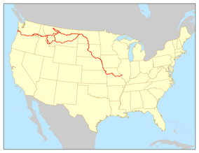
The Lewis and Clark National Historic Trail is a special route across the United States. It remembers the amazing journey of the Lewis and Clark Expedition from 1804 to 1806. This trail is part of the National Trails System, which protects important routes in the U.S.
The trail stretches for about 4,900 miles (7,900 km). It starts in Pittsburgh, Pennsylvania, and goes all the way to the mouth of the Columbia River in Oregon. That's a really long way!
The National Park Service helps manage this trail. However, many different groups also take care of parts of it. These include state, local, and tribal organizations. The Lewis and Clark Trail is not just one long hiking path. Instead, it offers many places where you can hike, go boating, or ride horses. It is the longest continuous trail in the National Trails System.
This historic trail follows the exact paths Lewis and Clark took. It includes their journey out west and their return trip. It also covers the preparation part of their adventure, starting from Pittsburgh. The trail connects 16 states, including Pennsylvania, Ohio, and Oregon. It also crosses many tribal lands.
Contents
What You Can See on the Trail
The main office for the Lewis and Clark Trail is in Omaha, Nebraska. This office is part of the National Park Service.
At the visitor center, you can learn all about the explorers. There are exhibits that tell the story of their historic trip. You can also find information about different places to visit along the trail.
Driving the Lewis and Clark Trail
There is a special highway route that follows the explorers' path. This route goes between St. Louis, Missouri, and the Pacific Ocean in Astoria, Oregon. It's like a road trip that takes you back in time!
The highway route mostly runs next to the Missouri River and the Columbia River. You might drive on roads like Interstate 29 in Iowa or Washington State Route 14. In some areas, there are two different routes you can take. These routes are marked on both sides of the Missouri River.
In Washington, this route is called the Lewis and Clark Trail Highway. It is a special scenic byway. The state decided in 1955 to name this highway corridor. It helps people enjoy the beautiful views along the Columbia River.
How the Trail Was Created
People have wanted to remember the Lewis and Clark journey for a long time. In 1948, the National Park Service first suggested a "Lewis and Clark Tour-way." This idea was for a route along the Missouri River.
Later, a man named Jay "Ding" Darling thought of making the expedition route into a fun trail. In 1968, a law called the National Trails System Act was passed. This law suggested studying the Lewis and Clark route as a possible National Scenic Trail.
Becoming a National Historic Trail
In 1978, the law was updated. It created a new type of trail called a National Historic Trail. The Lewis and Clark Trail was one of the first to get this special title. This meant it was recognized for its important history.
From 2003 to 2006, the National Park Service celebrated the 200th anniversary of the expedition. They had a traveling exhibit called "Corps of Discovery II." This exhibit helped many people learn about the explorers.
In 2019, a new law was passed. This law made the trail even longer! It added about 1,200 miles (1,900 km) along the Ohio and Mississippi Rivers. This extension goes from Pittsburgh, Pennsylvania, to Wood River, Illinois.
 | Dorothy Vaughan |
 | Charles Henry Turner |
 | Hildrus Poindexter |
 | Henry Cecil McBay |


