Ashland, Missouri facts for kids
Quick facts for kids
Ashland
|
|
|---|---|
| City of Ashland | |

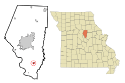
Location of Ashland, Missouri
|
|
| Country | United States |
| State | Missouri |
| County | Boone |
| Founded | 1853 |
| Incorporated | May 17, 1877 |
| Area | |
| • Total | 6.19 sq mi (16.02 km2) |
| • Land | 6.18 sq mi (16.00 km2) |
| • Water | 0.01 sq mi (0.03 km2) |
| Elevation | 896 ft (273 m) |
| Population
(2020)
|
|
| • Total | 4,747 |
| • Estimate
(2023)
|
5,026 |
| • Density | 768.50/sq mi (296.73/km2) |
| Time zone | UTC-6 (Central (CST)) |
| • Summer (DST) | UTC-5 (CDT) |
| ZIP code |
65010
|
| Area code(s) | 573 |
| FIPS code | 29-02242 |
| GNIS feature ID | 2393998 |
| Website | ashlandmo.us |
Ashland is a city located in Boone County, Missouri, in the United States. It is part of the Columbia, Missouri area. In 2020, the city had a population of 4,747 people.
Contents
History of Ashland
Ashland was founded in 1853. The city was named after the "Ashland estate" in Lexington, Kentucky. This estate belonged to Henry Clay, a well-known politician from Kentucky. Henry Clay played an important role in the Missouri Compromise of 1820. This agreement helped Missouri become the 24th state in the United States.
Geography and Area
According to the United States Census Bureau, Ashland covers a total area of about 4.80 square miles (12.43 square kilometers). Most of this area, about 4.79 square miles (12.41 square kilometers), is land. Only a small part, about 0.01 square miles (0.03 square kilometers), is water.
Population Changes Over Time
| Historical population | |||
|---|---|---|---|
| Census | Pop. | %± | |
| 1880 | 371 | — | |
| 1890 | 373 | 0.5% | |
| 1900 | 401 | 7.5% | |
| 1910 | 341 | −15.0% | |
| 1920 | 342 | 0.3% | |
| 1930 | 314 | −8.2% | |
| 1940 | 434 | 38.2% | |
| 1950 | 416 | −4.1% | |
| 1960 | 495 | 19.0% | |
| 1970 | 769 | 55.4% | |
| 1980 | 1,021 | 32.8% | |
| 1990 | 1,252 | 22.6% | |
| 2000 | 1,869 | 49.3% | |
| 2010 | 3,707 | 98.3% | |
| 2020 | 4,747 | 28.1% | |
| U.S. Decennial Census | |||
Ashland's Population in 2010
In 2010, there were 3,707 people living in Ashland. These people made up 1,428 households, with 990 of them being families. The city had about 774 people per square mile.
Most of the people living in Ashland were White (96.7%). There were also smaller groups of African American, Native American, and Asian residents. About 1.5% of the population identified as Hispanic or Latino.
Many households (42.4%) had children under 18 living with them. About half of the households (51.4%) were married couples. The average age in Ashland was 33.9 years. About 29.4% of residents were under 18 years old.
Education in Ashland
Ashland is served by the Southern Boone County R-1 Public School District. This district provides education for students from pre-school through high school.
The schools in the district include:
- Southern Boone High School (for students in grades 9 through 12)
- Southern Boone County Middle School (for students in grades 5 through 8)
- Southern Boone County Elementary School (for students in grades 3 and 4)
- Southern Boone County Primary School (for pre-school through second grade, and also offers a "Parents As Teachers" program)
The number of students in the Southern Boone County R-1 Public School District grew a lot. It doubled between 1991 and 2017. Ashland also has a public library. It is a part of the Daniel Boone Regional Library system.
Notable People from Ashland
- Dylan Frazier: He was the top-ranked men's doubles player in the Professional Pickleball Association in 2024.
- Eva Johnston: She was an academic who worked at the University of Missouri.
See Also
 In Spanish: Ashland (Misuri) para niños
 | Delilah Pierce |
 | Gordon Parks |
 | Augusta Savage |
 | Charles Ethan Porter |

