
Pettis County, Missouri facts for kids
Quick facts for kids
Pettis County
|
|
|---|---|

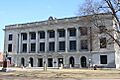
The Pettis County Courthouse in Sedalia
|
|

Location within the U.S. state of Missouri
|
|
 Missouri's location within the U.S. |
|
| Country | |
| State | |
| Founded | January 24, 1833 |
| Named for | Spencer Darwin Pettis |
| Seat | Sedalia |
| Largest city | Sedalia |
| Area | |
| • Total | 686 sq mi (1,780 km2) |
| • Land | 682 sq mi (1,770 km2) |
| • Water | 4.0 sq mi (10 km2) 0.6% |
| Population
(2020)
|
|
| • Total | 42,980 |
| • Density | 62.65/sq mi (24.190/km2) |
| Time zone | UTC−6 (Central) |
| • Summer (DST) | UTC−5 (CDT) |
| Congressional district | 4th |
Pettis County is a special area called a county in the middle-west part of Missouri, a state in the United States. In 2020, about 42,980 people lived here. The main city and government center of the county is Sedalia.
Pettis County was created on January 24, 1833. It was named after Spencer Darwin Pettis, who was a member of the U.S. Congress. This means he was elected to speak for the people of Missouri in the national government.
Sedalia, the county seat, is also home to the famous Missouri State Fair. This is a big event where people show off farm animals, crafts, and enjoy rides and food.
Contents
Where is Pettis County?
Pettis County covers a total area of about 686 square miles. Most of this area, 682 square miles, is land. The rest, about 4 square miles, is water. The county has rivers and streams, like the Lamine River, that help drain the land.
Neighboring Counties
Pettis County shares its borders with several other counties:
- To the north: Saline County
- To the east: Cooper County
- To the southeast: Morgan County
- To the south: Benton County
- To the southwest: Henry County
- To the west: Johnson County
- To the northwest: Lafayette County
Main Roads in Pettis County
Several important highways run through Pettis County, making it easy to travel around.
 U.S. Route 50
 U.S. Route 65
 Route 52
 Route 127
 Route 135
People of Pettis County
| Historical population | |||
|---|---|---|---|
| Census | Pop. | %± | |
| 1840 | 2,930 | — | |
| 1850 | 5,150 | 75.8% | |
| 1860 | 9,392 | 82.4% | |
| 1870 | 18,706 | 99.2% | |
| 1880 | 27,271 | 45.8% | |
| 1890 | 31,151 | 14.2% | |
| 1900 | 32,438 | 4.1% | |
| 1910 | 33,913 | 4.5% | |
| 1920 | 35,813 | 5.6% | |
| 1930 | 34,664 | −3.2% | |
| 1940 | 33,336 | −3.8% | |
| 1950 | 31,577 | −5.3% | |
| 1960 | 35,120 | 11.2% | |
| 1970 | 34,137 | −2.8% | |
| 1980 | 36,378 | 6.6% | |
| 1990 | 35,437 | −2.6% | |
| 2000 | 39,403 | 11.2% | |
| 2010 | 42,201 | 7.1% | |
| 2020 | 42,980 | 1.8% | |
| U.S. Decennial Census 1790–1960 1900–1990 1990–2000 2010 |
|||
The census is a count of all the people living in an area. In 2000, there were 39,403 people living in Pettis County. The population density was about 58 people for every square mile.
Many different groups of people make up Pettis County. In 2000, about 92% of the people were White. About 3% were Black or African American. Smaller groups included Native American and Asian people. About 3.88% of the population identified as Hispanic or Latino.
The average age of people in the county in 2000 was 36 years old. About 26% of the population was under 18 years old.
Population Changes in 2020
| Race | Num. | Perc. |
|---|---|---|
| White (NH) | 34,751 | 80.9% |
| Black or African American (NH) | 1,353 | 3.15% |
| Native American (NH) | 159 | 0.37% |
| Asian (NH) | 294 | 0.7% |
| Pacific Islander (NH) | 120 | 0.28% |
| Other/Mixed (NH) | 2,287 | 5.32% |
| Hispanic or Latino | 4,016 | 9.34% |
The 2020 census showed some changes. The total population grew to 42,980. The percentage of White residents decreased slightly to about 80.9%. The percentage of Hispanic or Latino residents increased to about 9.34%.
Education in Pettis County
Pettis County has many schools, both public and private. There are also colleges and libraries for learning.
Public Schools
Several public school districts serve the children of Pettis County:
- Green Ridge R-VIII School District in Green Ridge
- Green Ridge Elementary School (Kindergarten to 6th grade)
- Green Ridge High School (7th to 12th grade)
- La Monte R-IV School District in La Monte
- La Monte Elementary School (Pre-Kindergarten to 6th grade)
- La Monte High School (7th to 12th grade)
- Pettis County R-V School District in Hughesville
- Northwest Elementary School (Kindergarten to 6th grade)
- Northwest High School (7th to 12th grade)
- Pettis County R-XII School District in Sedalia
- Pettis County Elementary School (Pre-Kindergarten to 8th grade)
- Sedalia School District No. 200 in Sedalia
- Sedalia Early Childhood Education Center (Pre-Kindergarten)
- Heber Hunt Elementary School (Kindergarten to 4th grade)
- Skyline Elementary School (Kindergarten to 4th grade)
- Parkview Elementary School (Kindergarten to 4th grade)
- Horace Mann Elementary School (Kindergarten to 4th grade)
- Washington Elementary School (Kindergarten to 4th grade)
- Sedalia Middle School (5th grade)
- Smith-Cotton Junior High School (6th to 8th grade)
- Smith-Cotton High School (9th to 12th grade)
- Smithton R-VI School District in Smithton
- Smithton Elementary School (Pre-Kindergarten to 6th grade)
- Smithton High School (7th to 12th grade)
Private Schools
Private schools offer education with different teaching styles or religious connections:
- St. Paul's Lutheran School in Sedalia (Pre-Kindergarten to 8th grade) – connected to the Lutheran Church
- Sedalia Seventh-day Adventist School in Sedalia (1st to 8th grade) – connected to the Seventh-day Adventist Church
- Show-Me Christian School in La Monte (Kindergarten to 12th grade) – a Christian school
- Applewood Christian School in Sedalia (Kindergarten to 12th grade) – a Christian school
- Sacred Heart Schools in Sedalia (Kindergarten to 12th grade) – connected to the Roman Catholic Church
- Sacred Heart Elementary School (Kindergarten to 6th grade)
- Sacred Heart High School (7th to 12th grade)
College and Libraries
- State Fair Community College in Sedalia is a public college where students can earn a two-year degree.
- The county also has public libraries like the Boonslick Regional Library and the Sedalia Public Library. These are great places to find books and learn new things.
Towns and Communities
Pettis County is made up of several cities, towns, and smaller communities.
Cities and Towns
- Green Ridge
- Houstonia
- Hughesville
- Ionia
- La Monte
- Sedalia (the county seat)
- Smithton
- Windsor
Unincorporated Communities
These are smaller places that don't have their own local government, but they are still important parts of the county.
Images for kids
-
The Pettis County Courthouse in Sedalia
See also
 In Spanish: Condado de Pettis para niños
