Benton County, Missouri facts for kids
Quick facts for kids
Benton County
|
|
|---|---|

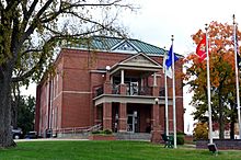
The Benton County Courthouse in Warsaw
|
|

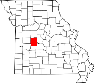
Location within the U.S. state of Missouri
|
|
 Missouri's location within the U.S. |
|
| Country | |
| State | |
| Founded | January 3, 1835 |
| Named for | Thomas Hart Benton |
| Seat | Warsaw |
| Largest city | Warsaw |
| Area | |
| • Total | 753 sq mi (1,950 km2) |
| • Land | 704 sq mi (1,820 km2) |
| • Water | 48 sq mi (120 km2) 6.4% |
| Population
(2020)
|
|
| • Total | 19,394 |
| • Density | 25.756/sq mi (9.944/km2) |
| Time zone | UTC−6 (Central) |
| • Summer (DST) | UTC−5 (CDT) |
| Congressional district | 4th |
Benton County is a county located in the west central part of the U.S. state of Missouri. The population was 19,394 as of the 2020 Census. Its county seat is Warsaw. The county was organized on January 3, 1835. It was named for U.S. Senator Thomas Hart Benton of Missouri.
Contents
Exploring Benton County
Benton County is a place with interesting geography and a growing population. It's a great spot to learn about how counties in the United States are set up.
Where is Benton County?
According to the U.S. Census Bureau, Benton County covers about 753 square miles (1,950 square kilometers). Most of this area, about 704 square miles (1,823 square kilometers), is land. The rest, about 48 square miles (124 square kilometers), is water.
Neighboring Counties
Benton County shares its borders with several other counties:
- Pettis County (to the north)
- Morgan County (to the northeast)
- Camden County (to the southeast)
- Hickory County (to the south)
- St. Clair County (to the southwest)
- Henry County (to the west)
Main Roads
Important highways that help people travel through Benton County include:
Population and People
Benton County has seen its population grow over the years. Understanding the people who live here helps us learn about the county's story.
How Many People Live Here?
| Historical population | |||
|---|---|---|---|
| Census | Pop. | %± | |
| 1840 | 4,205 | — | |
| 1850 | 5,015 | 19.3% | |
| 1860 | 9,072 | 80.9% | |
| 1870 | 11,322 | 24.8% | |
| 1880 | 12,396 | 9.5% | |
| 1890 | 14,973 | 20.8% | |
| 1900 | 16,556 | 10.6% | |
| 1910 | 14,881 | −10.1% | |
| 1920 | 12,989 | −12.7% | |
| 1930 | 11,708 | −9.9% | |
| 1940 | 11,142 | −4.8% | |
| 1950 | 9,080 | −18.5% | |
| 1960 | 8,737 | −3.8% | |
| 1970 | 9,695 | 11.0% | |
| 1980 | 12,183 | 25.7% | |
| 1990 | 13,859 | 13.8% | |
| 2000 | 17,180 | 24.0% | |
| 2010 | 19,056 | 10.9% | |
| 2020 | 19,394 | 1.8% | |
| U.S. Decennial Census 1790-1960 1900-1990 1990-2000 2010-2015 2019 |
|||
In 2000, there were 17,180 people living in Benton County. The population density was about 24 people per square mile. Most residents were White (about 98%). A small percentage identified as Native American, Black, Asian, or other races. About 1% of the population was of Hispanic or Latino background.
The county's population is spread across different age groups. In 2000, about 20.5% were under 18 years old. About 22.3% were 65 years or older. The average age was 46 years.
2020 Census Update
The most recent census in 2020 showed that Benton County's population grew to 19,394 people.
| Race | Number | Percentage |
|---|---|---|
| White (Non-Hispanic) | 17,934 | 92.5% |
| Black or African American (Non-Hispanic) | 75 | 0.4% |
| Native American (Non-Hispanic) | 100 | 0.52% |
| Asian (Non-Hispanic) | 51 | 0.26% |
| Pacific Islander (Non-Hispanic) | 0 | 0.06% |
| Other/Mixed (Non-Hispanic) | 924 | 4.8% |
| Hispanic or Latino | 310 | 1.6% |
Religious Beliefs
Benton County is part of what is known as the "Bible Belt." This means that many people in the area follow evangelical Protestant religions. The most common groups are Southern Baptists, Lutherans (LCMS), and United Methodists.
Learning and Education
Education is important in Benton County, with several public and private schools serving students from kindergarten through high school.
Public Schools
- Cole Camp R-I School District in Cole Camp
- Cole Camp Elementary School (Grades PK-5)
- Cole Camp Middle School (Grades 6-8)
- Cole Camp High School (Grades 9-12)
- Lincoln R-II School District in Lincoln
- Lincoln Elementary School (Grades K-6)
- Lincoln High School (Grades 7-12)
- Warsaw R-IX School District in Warsaw
- North Elementary School (Grades PK-5)
- South Elementary School (Grades PK-5)
- John Boise Middle School (Grades 6-8)
- Warsaw High School (Grades 9-12)
Private Schools
- Cornerstone Academy of the Ozarks in Warsaw (Grades PK-12) – This is a Christian school.
- Lutheran School Association in Cole Camp (Grades K-8) – This school is connected to the Lutheran Church–Missouri Synod. Many students from this school later attend Benton County R-1 High in Cole Camp.
Public Libraries
- Boonslick Regional Library provides library services to the community.
Towns and Villages
Benton County has several communities, including cities, a village, and other smaller places where people live.
Cities
- Cole Camp
- Lincoln
- Warsaw (This is the county seat, meaning it's where the county government is located.)
Village
Other Communities
These are smaller areas or neighborhoods within the county:
Well-Known People
Benton County is home to or has connections with several notable individuals.
- Martin Heinrich – He is a U.S. Senator for New Mexico (since 2013). Before that, he was a U.S. Representative for New Mexico (2009-2013).
- Stan Kroenke – He is a well-known sports team owner. He owns the Los Angeles Rams (an American football team), the Denver Nuggets (a basketball team), and the Colorado Avalanche (a hockey team). He is also a major owner of the English soccer club Arsenal.
- Carol Junge Loomis – A journalist who worked for Fortune magazine for over 60 years before retiring in 2014.
See also
 In Spanish: Condado de Benton (Misuri) para niños
 | Emma Amos |
 | Edward Mitchell Bannister |
 | Larry D. Alexander |
 | Ernie Barnes |

