
Warsaw, Missouri facts for kids
Quick facts for kids
Warsaw, Missouri
|
|
|---|---|
| City of Warsaw | |

Benton County Courthouse in Warsaw
|
|

Location of Warsaw, Missouri
|
|
| Country | United States |
| State | Missouri |
| County | Benton |
| Founded | 1837 |
| Incorporated | 1843 |
| Area | |
| • Total | 2.75 sq mi (7.11 km2) |
| • Land | 2.49 sq mi (6.46 km2) |
| • Water | 0.25 sq mi (0.65 km2) |
| Elevation | 745 ft (227 m) |
| Population
(2020)
|
|
| • Total | 2,209 |
| • Estimate
(2023)
|
2,334 |
| • Density | 886.08/sq mi (342.18/km2) |
| Time zone | UTC-6 (Central (CST)) |
| • Summer (DST) | UTC-5 (CDT) |
| ZIP code |
65355
|
| Area code(s) | 660 |
| FIPS code | 29-77146 |
| GNIS feature ID | 2397201 |
| Website | www.welcometowarsaw.com |
Warsaw is a city in Benton County, Missouri, United States. It is the main city, or county seat, of Benton County. In 2020, about 2,209 people lived there.
Warsaw is located next to the Osage River. It is also very close to two big lakes on the river. The top part of Lake of the Ozarks touches the city's southwest edge. The Truman Dam and Truman Reservoir are on its northwest side.
Contents
History of Warsaw
The first people to live in this area were Native American tribes. These included the Delaware, Shawnee, Sac, Kickapoo, and Osage tribes. The Osage River is named after the Osage tribe. French explorers visited the area as early as 1719.
Warsaw was officially planned out in 1837. It became a city in 1843. It was also chosen as the county seat for Benton County. The city was named after Warsaw, the capital of Poland. This was done to honor Tadeusz Kościuszko. He was a Polish hero who fought in the American Revolutionary War. He also fought for freedom in his home country.
Warsaw was an important port for steamboats. It was the furthest point up the Osage River that steamboats could travel. Later, people from Germany, Scotland-Ireland, and England moved here. Farmers from Kentucky, Tennessee, and the Carolinas also settled here around 1820.
In 1931, the upper part of Lake of the Ozarks reached the city on the Osage River. The dam for Truman Reservoir is just northwest of Warsaw. Construction on this dam started in 1964 and it opened in 1979. Many businesses near the lake use Warsaw's mailing address. This is true even if they are outside the city limits. Warsaw's city limits do not include the Truman Reservoir lakefront. However, they do include the waterfront of the Osage Arm of the Lake of the Ozarks.
The Upper Bridge was added to the National Register of Historic Places in 1999. This bridge is the first crossing of the Osage River below the Truman Dam. It actually crosses a part of Lake of the Ozarks.
Geography of Warsaw
Warsaw is located at 38°14'43" North, 93°22'38" West. The city covers about 2.62 square miles (6.79 square kilometers). Most of this area is land, about 2.41 square miles (6.24 square kilometers). The rest, about 0.21 square miles (0.54 square kilometers), is water. About 7.6% of the city's total area is water. This is because its southern border touches the upper parts of Lake of the Ozarks.
Warsaw is located where U.S. Route 65 and Missouri Route 7 meet. It is also the northern end of Missouri Route 83.
Climate and Weather
Warsaw has seen some extreme temperatures. On July 14, 1954, the temperature reached 117.9°F (47.7°C). This is the hottest temperature ever recorded in Missouri. On February 13, 1905, the temperature dropped to −40°F (−40°C). This is the coldest temperature ever recorded in Missouri. The average temperature each year is about 56.7°F (13.7°C).
| Climate data for Truman Dam, Warsaw, Missouri, 1991–2020 normals, extremes 1980–present | |||||||||||||
|---|---|---|---|---|---|---|---|---|---|---|---|---|---|
| Month | Jan | Feb | Mar | Apr | May | Jun | Jul | Aug | Sep | Oct | Nov | Dec | Year |
| Record high °F (°C) | 73 (23) |
81 (27) |
87 (31) |
92 (33) |
95 (35) |
104 (40) |
108 (42) |
108 (42) |
105 (41) |
94 (34) |
84 (29) |
76 (24) |
108 (42) |
| Mean maximum °F (°C) | 64.5 (18.1) |
70.3 (21.3) |
78.8 (26.0) |
84.2 (29.0) |
88.6 (31.4) |
93.3 (34.1) |
98.0 (36.7) |
98.7 (37.1) |
93.4 (34.1) |
85.7 (29.8) |
74.9 (23.8) |
66.5 (19.2) |
99.8 (37.7) |
| Mean daily maximum °F (°C) | 42.5 (5.8) |
46.8 (8.2) |
57.0 (13.9) |
67.7 (19.8) |
76.1 (24.5) |
84.9 (29.4) |
89.7 (32.1) |
88.8 (31.6) |
81.6 (27.6) |
69.9 (21.1) |
57.3 (14.1) |
46.4 (8.0) |
67.4 (19.7) |
| Daily mean °F (°C) | 32.2 (0.1) |
36.0 (2.2) |
45.4 (7.4) |
55.7 (13.2) |
65.6 (18.7) |
74.9 (23.8) |
79.6 (26.4) |
78.0 (25.6) |
70.1 (21.2) |
58.1 (14.5) |
46.5 (8.1) |
36.5 (2.5) |
56.6 (13.7) |
| Mean daily minimum °F (°C) | 21.9 (−5.6) |
25.1 (−3.8) |
33.9 (1.1) |
43.7 (6.5) |
55.1 (12.8) |
64.9 (18.3) |
69.4 (20.8) |
67.3 (19.6) |
58.5 (14.7) |
46.3 (7.9) |
35.6 (2.0) |
26.7 (−2.9) |
45.7 (7.6) |
| Mean minimum °F (°C) | 4.5 (−15.3) |
9.6 (−12.4) |
17.6 (−8.0) |
29.7 (−1.3) |
40.9 (4.9) |
52.9 (11.6) |
59.9 (15.5) |
57.3 (14.1) |
44.5 (6.9) |
31.3 (−0.4) |
20.9 (−6.2) |
10.8 (−11.8) |
1.3 (−17.1) |
| Record low °F (°C) | −12 (−24) |
−17 (−27) |
2 (−17) |
21 (−6) |
32 (0) |
44 (7) |
53 (12) |
44 (7) |
29 (−2) |
22 (−6) |
5 (−15) |
−20 (−29) |
−20 (−29) |
| Average precipitation inches (mm) | 1.75 (44) |
2.14 (54) |
3.04 (77) |
4.60 (117) |
5.52 (140) |
5.24 (133) |
4.70 (119) |
3.96 (101) |
4.11 (104) |
3.45 (88) |
3.06 (78) |
1.97 (50) |
43.54 (1,106) |
| Average precipitation days (≥ 0.01 in) | 6.6 | 5.9 | 9.7 | 11.6 | 12.2 | 9.6 | 8.2 | 8.0 | 8.0 | 9.3 | 7.4 | 5.7 | 102.2 |
| Source 1: NOAA | |||||||||||||
| Source 2: National Weather Service | |||||||||||||
Population Changes
The number of people living in Warsaw has changed over the years. Here's how the population has grown:
| Historical population | |||
|---|---|---|---|
| Census | Pop. | %± | |
| 1880 | 515 | — | |
| 1890 | 700 | 35.9% | |
| 1900 | 743 | 6.1% | |
| 1910 | 824 | 10.9% | |
| 1920 | 925 | 12.3% | |
| 1930 | 1,102 | 19.1% | |
| 1940 | 957 | −13.2% | |
| 1950 | 936 | −2.2% | |
| 1960 | 1,054 | 12.6% | |
| 1970 | 1,423 | 35.0% | |
| 1980 | 1,494 | 5.0% | |
| 1990 | 1,696 | 13.5% | |
| 2000 | 2,070 | 22.1% | |
| 2010 | 2,127 | 2.8% | |
| 2020 | 2,209 | 3.9% | |
| U.S. Decennial Census | |||
What the 2010 Census Showed
In 2010, the census counted 2,127 people living in Warsaw. There were 914 households, which are groups of people living together. About 523 of these were families. The city had about 882.6 people per square mile (340.8 people per square kilometer).
Most people in Warsaw were White (96.3%). There were also smaller groups of African American (1.0%), Native American (1.1%), and Asian (0.2%) residents. Some people were from other races (0.4%) or from two or more races (0.9%). About 3.2% of the population was Hispanic or Latino.
About 27.4% of households had children under 18 living with them. About 41.6% were married couples. Some households had a female head with no husband (12.1%). A small number had a male head with no wife (3.5%). About 42.8% were not families. Many households (37.7%) had only one person living there. About 21% of households had someone aged 65 or older living alone. The average household had 2.20 people, and the average family had 2.88 people.
The average age in the city was 45 years old. About 22.7% of residents were under 18. About 6% were between 18 and 24. Around 21.2% were 25 to 44 years old. About 25.1% were 45 to 64. And 25% were 65 years or older. The city had slightly more females (53.3%) than males (46.7%).
Education in Warsaw
The Warsaw R-IX School District runs four schools in Warsaw:
- North Elementary School
- South Elementary School
- John Boise Middle School
- Warsaw High School
Warsaw also has a private school called Cornerstone Academy of the Ozarks. It teaches students from kindergarten through 12th grade.
The city has a public library. It is a part of the Boonslick Regional Library system.
Images for kids
-
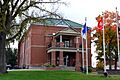
Benton County Courthouse in Warsaw
-
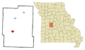
Location of Warsaw, Missouri
See also
 In Spanish: Warsaw (Misuri) para niños
