
Osage River facts for kids
Quick facts for kids Osage River |
|
|---|---|

Map of the Osage River watershed showing the Niangua River
|
|
| Country | United States |
| State | Missouri Kansas |
| Region | Osage Plains, Ozarks |
| City | Warsaw, Lake Ozark, Tuscumbia, St. Thomas |
| Physical characteristics | |
| River mouth | Missouri River Bonnots Mill, Missouri 518 ft (158 m) 38°35′49″N 91°56′43″W / 38.59694°N 91.94528°W |
| Length | 276 mi (444 km) |
| Basin features | |
| Basin size | 15,300 sq mi (40,000 km2) |
| Tributaries | |
| Watersheds | Osage-Missouri-Mississippi |
The Osage River is a 276-mile-long (444 km) river in central Missouri, United States. It flows into the Missouri River. It's the eighth-largest river in Missouri. The Osage River drains a large area of 15,300 square miles (40,000 km2), which is mostly countryside. This area includes parts of east-central Kansas and a big part of west-central and central Missouri. It also drains the northwest areas of the Ozark Plateau.
The river generally flows east, then turns northeast for its last 80 miles (130 km) before joining the Missouri River. Two large dams have turned most of the river into two big lakes: the Harry S. Truman Reservoir and the Lake of the Ozarks.
Contents
Journey of the Osage River
The Osage River starts in southwestern Missouri. It forms about 14 miles (23 km) northeast of Nevada. This is where the Marais des Cygnes River and the Little Osage River meet. Sometimes, the Marais des Cygnes River is considered part of the Osage. If so, the Osage River would start in eastern Kansas and be over 500 miles (800 km) long!
The river flows east past the Schell-Osage Wildlife Area. Then, it widens into a long, winding arm of the Harry S. Truman Reservoir. This part of the lake is about 40 miles (64 km) long. The reservoir also gets water from the South Grand River and the Pomme de Terre River. These two parts of the lake meet near the Harry S. Truman Dam in central Benton County.
After the Truman Dam, the river becomes the curvy Lake of the Ozarks. This lake stretches eastward for almost 92 miles (148 km) to Bagnell Dam. The Bagnell Dam was built in 1931 and collects water from the Niangua River. After the Bagnell Dam, the Osage River flows freely northeast. It makes wide, U-shaped bends through wooded hills. Finally, it joins the Missouri River about 15 miles (24 km) east of Jefferson City.
A Look Back: History of the Osage River
The river gets its name from the Osage Nation. These were the native people who lived in this area when the first European settlers arrived. Early settlers found it hard to travel on the river. Its water levels changed a lot. Also, there were shallow spots and sand banks because the river twisted and turned through the hills.
The Missouri Legislature tried to make the river deeper as early as 1839. But these early attempts failed because there wasn't enough money for such a huge job. In the 1800s, only smaller boats could use the river for trade. These boats were able to handle the tight turns and shallow areas. By the late 1800s, improvements to the river channel helped more boats use it. These changes made the lower parts of the river usable for steamboat trade for about six to nine months each year.
Crossing the River: Ferries and Dams
Before the Bagnell Dam was built, people crossed the river using the Bagnell Ferry. This ferry started in 1882. Samuel Umpsted was the person in charge of it. Sadly, there were several ferry accidents, including sinkings, which caused some people to die. The ferry stopped being used much around 1940, years after the dam was finished.
Power from the River: Dams and Electricity
In the 1900s, a private company started building the Bagnell Dam in 1922. It took nine years to finish. The main goal was to create hydroelectricity, which is power made from moving water. This dam stopped boats from traveling on the river for trade. Later, the federal government built the Truman Dam. This dam was approved in 1954 and finished in 1979.
The two dams on the river create electricity for the St. Louis area. The large lakes created by these dams have become popular places for tourists and for fun activities in the region.
Images for kids
-
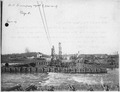
Views of cofferdam, where new Chanoine Dam is under construction, November 3, 1909
See also
 In Spanish: Río Osage para niños
