Niangua River facts for kids
Quick facts for kids Niangua River |
|
|---|---|

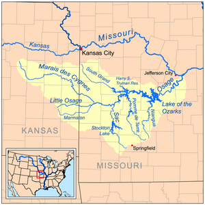
Map of the Osage River watershed showing the Niangua River
|
|
| Country | United States |
| State | Missouri |
| Physical characteristics | |
| Main source | Webster County, Missouri 1,136 ft (346 m) 37°26′46″N 92°55′11″W / 37.44611°N 92.91972°W |
| River mouth | Lake of the Ozarks Camden County, Missouri 663 ft (202 m) 37°57′39″N 92°48′22″W / 37.96083°N 92.80611°W |
| Length | 125 mi (201 km) |
| Basin features | |
| Basin size | 1,040 sq mi (2,700 km2) |
| Tributaries |
|
| Watersheds | Niangua-Osage-Missouri-Mississippi |
The Niangua River is a 125-mile-long (201 km) river in the state of Missouri, United States. It flows through the beautiful Ozarks region. This river is a tributary of the Osage River, meaning it flows into the Osage.
The Niangua River is part of a much larger water system. Its waters eventually join the Missouri and then the mighty Mississippi River. This whole area is called the watershed of the Mississippi River.
What's in a Name?
The name Niangua comes from an Indian tribal leader named Niangua (or Nehemgar). It is believed that the name means "bear."
River's Journey: Where it Flows
The Niangua River starts in Webster County. It is formed by two smaller streams, called the east and west forks, joining together. From there, the river generally flows north.
As it travels, the Niangua River passes through several counties, including Dallas, Laclede, and Camden. Along its path, you can find popular spots like Bennett Spring and Ha Ha Tonka State Parks.
The river eventually flows into the Osage River. At this point, it becomes an arm of the Lake of the Ozarks. This large lake was created by the Bagnell Dam on the Osage River. The Niangua River also collects water from the Little Niangua River as it joins the lake.
Exploring the River: Access Points
Many places allow people to get to the Niangua River. These "access points" are great for fishing, floating, or just enjoying nature. They are located all along the river, from its beginning to where it meets the Lake of the Ozarks.
Some access points are owned by the state, like Charity Access and Big John Access. These often have rules about camping. Other spots are privately owned and might offer extra services like campgrounds or shuttle services.
Here are a few examples of places where you can access the Niangua River:
- Bridal Cave
- Hico Slab: A low concrete bridge where the river flows over the top.
- Hwy. K-P Bridge Access: This spot has a private campground and picnic area.
- Bennett Spring Access: A state-owned access point.
- Lake Niangua: Offers access and a picnic area.
- Ha Ha Tonka State Park: This is where the river merges into the Lake of the Ozarks.
 | Frances Mary Albrier |
 | Whitney Young |
 | Muhammad Ali |

