Webster County, Missouri facts for kids
Quick facts for kids
Webster County
|
|
|---|---|

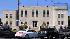
Webster County Courthouse in Marshfield
|
|

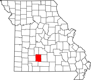
Location within the U.S. state of Missouri
|
|
 Missouri's location within the U.S. |
|
| Country | |
| State | |
| Founded | March 3, 1854 |
| Named for | Daniel Webster |
| Seat | Marshfield |
| Largest city | Marshfield |
| Area | |
| • Total | 594 sq mi (1,540 km2) |
| • Land | 593 sq mi (1,540 km2) |
| • Water | 1.2 sq mi (3 km2) 0.2% |
| Population
(2020)
|
|
| • Total | 39,085 |
| • Estimate
(2022)
|
41,472 |
| • Density | 68/sq mi (26/km2) |
| Time zone | UTC−6 (Central) |
| • Summer (DST) | UTC−5 (CDT) |
| Congressional districts | 4th, 7th |
Webster County is a county in Missouri, a state in the United States. In 2020, about 39,085 people lived here. The main town, or county seat, is Marshfield.
The county started in 1855. It was named after Daniel Webster. He was a famous U.S. Senator and a Secretary of State. Webster County is also part of the larger Springfield, Missouri area.
Contents
History of Webster County
Webster County was created on March 3, 1855. It is in the high Ozarks area of Missouri. Marshfield, the county seat, is 1,490 feet above sea level. This makes it the highest county seat in Missouri. A lawmaker named John F. McMahan chose the names for the county and Marshfield. He named them after Daniel Webster and his home in Marshfield, Massachusetts.
Marshfield was planned in 1856. The land was given by C.F. Dryden and W.T. and B.F.T. Burford. At first, county business happened in Hazelwood. This was where Joseph W. McClurg, who later became Governor of Missouri, had a store. The current courthouse was built between 1939 and 1941. It is the third courthouse for the county.
During the U.S. Civil War, soldiers who supported the South were forced out of Marshfield in February 1862. Later, in December, Southern troops were defeated east of town. On January 9, 1863, General Joseph O. Shelby's troops burned Union forts in Marshfield and Sand Springs. These forts had been left empty earlier. On the same day, Confederate troops also burned the fort at Hazelwood. By 1862, a telegraph line, later called the "Old Wire Road," passed near Marshfield.
The land in Webster County was once part of a deal with the Osage Native American tribe in 1808. Pioneers from Kentucky and Tennessee started settling here in the early 1830s. An old Native American trail crossed the southern part of the county. Many ancient mounds can also be found in the area.
After the Civil War, railroads helped the county grow. Webster County became known for its dairy, poultry, and livestock farms. The Atlantic & Pacific (Frisco) Railroad reached Marshfield in 1872. By 1883, another railroad, the Kansas City, Springfield, and Memphis (Frisco), crossed the county. Towns like Seymour, Rogersville, Fordland, and Niangua grew up along these railroad lines.
Some of the first schools in the county were Marshfield Academy (started 1860), Mt. Dale Academy (opened 1873), and Henderson Academy (started 1879).
On April 18, 1880, a very strong tornado hit Marshfield. It was an F4 tornado, which is very powerful. The tornado was 800 yards wide and traveled 64 miles. It killed 99 people and injured 100. It is said that 10% of Marshfield's people died, and almost all buildings were destroyed. A song called "Marshfield Cyclone" by musician John W. (Blind) Boone made the event famous. This tornado is still one of the worst natural disasters in U.S. history.
The famous astronomer Edwin P. Hubble (1889–1953) was born in Marshfield. He went to school there until third grade. A model of the Hubble telescope is in the courthouse yard. A part of I-44 near Marshfield is named after him.
Marshfield claims to have the oldest Independence Day parade west of the Mississippi River. Former President George Herbert Walker Bush and his wife Barbara visited the parade on July 4, 1991. Webster County also has the longest-running county fair in Missouri.
The annual Seymour Apple Festival started in 1973. It has become one of Missouri's largest free events. More than 30,000 people gather in Seymour each September. The festival celebrates Seymour's apple growing history. In the early 1900s, Webster County grew over half of Missouri's apples. Seymour was even called "The Land Of The Big Red Apple."
Geography of Webster County
Webster County is located on a high point of land. This area divides the water flow between the Missouri and White rivers. The beginnings of the James, Niangua, Gasconade, and Pomme de Terre rivers are all in Webster County.
The U.S. Census Bureau says the county covers 594 square miles. Most of this (593 square miles) is land. Only 1.2 square miles (0.2%) is water.
Neighboring Counties
- Dallas County (northwest)
- Laclede County (northeast)
- Wright County (east)
- Douglas County (southeast)
- Christian County (southwest)
- Greene County (west)
Main Roads
 Interstate 44
 U.S. Route 60
 Route 38
Population and People
| Historical population | |||
|---|---|---|---|
| Census | Pop. | %± | |
| 1860 | 7,099 | — | |
| 1870 | 10,434 | 47.0% | |
| 1880 | 12,175 | 16.7% | |
| 1890 | 15,177 | 24.7% | |
| 1900 | 16,640 | 9.6% | |
| 1910 | 17,377 | 4.4% | |
| 1920 | 16,609 | −4.4% | |
| 1930 | 16,148 | −2.8% | |
| 1940 | 17,226 | 6.7% | |
| 1950 | 15,072 | −12.5% | |
| 1960 | 13,753 | −8.8% | |
| 1970 | 15,562 | 13.2% | |
| 1980 | 20,414 | 31.2% | |
| 1990 | 23,753 | 16.4% | |
| 2000 | 31,045 | 30.7% | |
| 2010 | 36,202 | 16.6% | |
| 2020 | 39,085 | 8.0% | |
| 2023 (est.) | 41,472 | 14.6% | |
| U.S. Decennial Census 1790-1960 1900-1990 1990-2000 2010 2023 |
|||
In 2000, there were 31,045 people living in Webster County. There were 11,073 households and 8,437 families. About 52 people lived per square mile.
Most people in the county were White (96.20%). About 1.16% were Black or African American. Around 1.29% of the population was Hispanic or Latino.
About 37.90% of households had children under 18. Most households (64.00%) were married couples. The average household had 2.72 people. The average family had 3.14 people.
The population was spread out by age:
- 28.90% were under 18.
- 8.30% were 18 to 24.
- 29.70% were 25 to 44.
- 21.70% were 45 to 64.
- 11.40% were 65 or older.
The average age was 35 years.
The median income for a household was $39,948. For a family, it was $46,941. About 14.80% of the population lived below the poverty line. This included 21.00% of those under 18.
2020 Census Information
In 2020, the population of Webster County was 39,085.
| Race | Num. | Perc. |
|---|---|---|
| White (NH) | 35,893 | 92% |
| Black or African American (NH) | 194 | 0.5% |
| Native American (NH) | 243 | 0.62% |
| Asian (NH) | 141 | 0.36% |
| Pacific Islander (NH) | 9 | 0.02% |
| Other/Mixed (NH) | 1,815 | 4.6% |
| Hispanic or Latino | 790 | 2% |
Education in Webster County
Public Schools
- Fordland R-III School District - Fordland
- Fordland Elementary School (Grades K-5)
- Fordland Middle School (Grades 6-8)
- Fordland High School (Grades 9-12)
- Logan-Rogersville R-VIII School District - Rogersville
- Logan-Rogersville Primary School (Grades PK-1)
- Logan-Rogersville Elementary School (Grades 2-3)
- Logan-Rogersville Upper Elementary School (Grades 4-6)
- Logan-Rogersville Middle School (Grades 7-8)
- Logan-Rogersville High School (Grades 9-12)
- Marshfield R-I School District - Marshfield
- Edwin P. Hubble Elementary School (Grades K-1)
- Daniel Webster Elementary School (Grades 2-3)
- Shook Elementary School (Grades 4-5)
- Marshfield Jr. High School (Grades 6-8)
- Marshfield High School (Grades 9-12)
- Niangua R-V School District - Niangua
- Niangua Elementary School (Grades K-6)
- Niangua High School (Grades 7-12)
- Seymour R-II School District - Seymour
- Seymour Elementary School (Grades PK-5)
- Seymour Middle School (Grades 6-8)
- Seymour High School (Grades 9-12)
- Some schools are shared with nearby counties:
- Conway School (Laclede County R-1 School District)
- Fair Grove School (Greene County R-10 School District)
- Strafford School (Greene County R-6 School District)
Private Schools
- Ozark Mennonite School - Seymour (Grades 1-10) - This is a Mennonite school.
Public Libraries
- Garst Memorial Library (Marshfield)
- Rogersville Branch Library
- Seymour Public Library
Towns and Communities
Cities
- Fordland
- Marshfield (county seat)
- Niangua
- Rogersville
- Seymour
- Strafford
Village
Unincorporated Communities
These are smaller communities without their own local government.
See also
 In Spanish: Condado de Webster (Misuri) para niños
 | Leon Lynch |
 | Milton P. Webster |
 | Ferdinand Smith |

