Laclede County, Missouri facts for kids
Quick facts for kids
Laclede County
|
|
|---|---|

Laclede County Courthouse in Lebanon
|
|

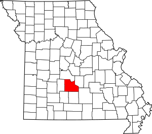
Location within the U.S. state of Missouri
|
|
 Missouri's location within the U.S. |
|
| Country | |
| State | |
| Founded | February 24, 1849 |
| Named for | Pierre Laclede |
| Seat | Lebanon |
| Largest city | Lebanon |
| Area | |
| • Total | 768 sq mi (1,990 km2) |
| • Land | 765 sq mi (1,980 km2) |
| • Water | 3.3 sq mi (9 km2) 0.4% |
| Population
(2020)
|
|
| • Total | 36,039 |
| • Density | 46.926/sq mi (18.118/km2) |
| Time zone | UTC−6 (Central) |
| • Summer (DST) | UTC−5 (CDT) |
| Congressional district | 4th |
Laclede County is a special area called a county in the state of Missouri. In 2020, about 36,039 people lived here. The main town, or county seat, is Lebanon. The county was officially started on February 24, 1849. It was named after Pierre Laclède, who helped start the big city of St. Louis.
Laclede County is also part of a larger area called the Lebanon, MO Micropolitan Statistical Area. This means it's a central place for jobs and living for many people.
Contents
Geography of Laclede County
Laclede County covers a total area of about 768 square miles. Most of this is land, around 765 square miles. A small part, about 3.3 square miles, is water. That's about 0.4% of the total area.
Neighboring Counties
Laclede County shares its borders with several other counties:
- Camden County to the north
- Pulaski County to the northeast
- Texas County to the southeast
- Wright County to the south
- Webster County to the southwest
- Dallas County to the west
Main Roads and Highways
Several important roads run through Laclede County, making it easy to travel:
 Interstate 44 is a major highway.
 U.S. Route 66 was a famous old highway.
 Route 5
 Route 7
 Route 17
 Route 32
 Route 64
 Route 64A
Protected Natural Areas
Part of the Mark Twain National Forest is located in Laclede County. This is a large forest area protected for its natural beauty and wildlife.
People of Laclede County
The number of people living in Laclede County has grown a lot over the years.
| Historical population | |||
|---|---|---|---|
| Census | Pop. | %± | |
| 1850 | 2,498 | — | |
| 1860 | 5,182 | 107.4% | |
| 1870 | 9,380 | 81.0% | |
| 1880 | 11,524 | 22.9% | |
| 1890 | 14,721 | 27.7% | |
| 1900 | 16,523 | 12.2% | |
| 1910 | 17,363 | 5.1% | |
| 1920 | 16,857 | −2.9% | |
| 1930 | 16,320 | −3.2% | |
| 1940 | 18,718 | 14.7% | |
| 1950 | 19,010 | 1.6% | |
| 1960 | 18,991 | −0.1% | |
| 1970 | 19,944 | 5.0% | |
| 1980 | 24,323 | 22.0% | |
| 1990 | 27,158 | 11.7% | |
| 2000 | 32,513 | 19.7% | |
| 2010 | 35,571 | 9.4% | |
| 2020 | 36,039 | 1.3% | |
| U.S. Decennial Census 1790-1960 1900-1990 1990-2000 2010 |
|||
In 2020, the population was 36,039 people. Most people in the county are White (about 90%). There are also smaller groups of Black or African American, Native American, Asian, and Pacific Islander people. About 2.65% of the population is Hispanic or Latino.
The average age of people in the county in 2000 was 37 years old. About 26.7% of the population was under 18 years old.
Education in Laclede County
Laclede County has many schools for students of all ages.
Public Schools
There are several public school districts in the county:
- Laclede County R-I School District in Conway
- Ezard Elementary School (Grades PK-6)
- Conway Junior High School (Grades 7-8)
- Conway High School (Grades 9-12)
- Gasconade C-4 School District in Falcon
- Gasconade Elementary School (Grades PK-8)
- Lebanon R-III School District in Lebanon
- Joe D. Esther Elementary School (Grades PK-1)
- Maplecrest Elementary School (Grades 2-3)
- Boswell Elementary School (Grades 4-5)
- Lebanon Middle School (Grades 6-8)
- Lebanon High School (Grades 9-12)
- Joel E. Barber C-5 School District in Lebanon
- Joel E. Barber Elementary School (Grades PK-8)
- Stoutland R-II School District in Stoutland
- Stoutland Elementary School (Grades PK-6)
- Stoutland High School (Grades 7-12)
Colleges and Universities
For students who want to continue their education after high school, there are several options:
- Ozarks Technical Community College [1]
- Drury University [2]
- Lebanon College of Cosmetology [3]
- Missouri State University Outreach-Lebanon [4]
Public Libraries
The Lebanon-Laclede County Library provides books, resources, and programs for everyone in the community.
Communities in Laclede County
Laclede County is made up of several cities, villages, and other smaller communities.
Cities
- Conway
- Lebanon (This is the main town, the county seat!)
- Richland (Most of this city is in Pulaski County and a small part in Camden County)
Villages
- Evergreen
- Phillipsburg
- Stoutland (Most of this village is in Camden County)
Townships
Townships are smaller areas within the county:
- Auglaize
- Eldridge
- Franklin
- Gasconade
- Lebanon
- Osage
- Phillipsburg
- Spring Hollow
- Washington
Census-Designated Place
- Bennett Springs is a special area recognized for counting people.
Other Small Communities
See also
 In Spanish: Condado de Laclede para niños
 | Audre Lorde |
 | John Berry Meachum |
 | Ferdinand Lee Barnett |

