Camden County, Missouri facts for kids
|
Camden County
|
|
|---|---|
Quick facts for kids
|
|

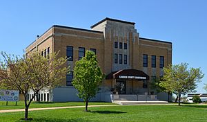
The Camden County Courthouse in Camdenton
|
|

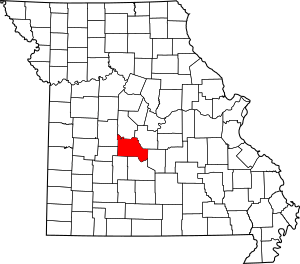
Location within the U.S. state of Missouri
|
|
 Missouri's location within the U.S. |
|
| Country | |
| State | |
| Founded | January 29, 1841 |
| Named for | Charles Pratt, 1st Earl Camden |
| Seat | Camdenton |
| Largest city | Osage Beach |
| Area | |
| • Total | 709 sq mi (1,840 km2) |
| • Land | 656 sq mi (1,700 km2) |
| • Water | 53 sq mi (140 km2) 7.4% |
| Population
(2020)
|
|
| • Total | 42,745 |
| • Estimate
(2022)
|
43,768 |
| • Density | 60.29/sq mi (23.278/km2) |
| Time zone | UTC−6 (Central) |
| • Summer (DST) | UTC−5 (CDT) |
| Congressional districts | 3rd, 4th |
Camden County is a county in the state of Missouri. In 2020, about 42,745 people lived there. The main town, or county seat, is Camdenton.
The county was first set up on January 29, 1841. It was called Kinderhook County back then. In 1843, its name changed to Camden County. It was named after Charles Pratt, 1st Earl Camden. He was an important leader in the United Kingdom. Camden County is also where the Netflix show Ozark takes place.
Contents
History
Early Settlers
People started living in the area that is now Camden County around 1827. The first known settlers were Harrison Davis and Reuben Berry from Kentucky. They set up a camp near Dry Auglaize Creek.
More families moved to the area over the next few years. By 1831, thirteen families lived near Dry Auglaize Creek. The first school in Camden County was built on a farm in 1833.
First County Seat
The town of Oregon was started in 1841. It became the county seat, which is the main town for county government. When the county's name changed to Camden in 1843, Oregon's name changed to Erie.
In 1854, a serious illness called cholera hit Erie. Only seven people survived. Because of this, the county seat moved to Linn Creek in 1855.
The Civil War
Camden County saw some fighting during the American Civil War.
Battle of Monday's Hollow
| Battle of Monday's Hollow | |||||||
|---|---|---|---|---|---|---|---|
| Part of the American Civil War | |||||||
|
|||||||
| Belligerents | |||||||
| Commanders and leaders | |||||||
| Units involved | |||||||
|
|
|||||||
| Casualties and losses | |||||||
| 1 killed | Approximately 100 killed and wounded | ||||||
On October 13, 1861, the Battle of Monday's Hollow happened. Union soldiers led by Colonel John Wyman marched towards Linn Creek. Other Union groups, led by Major Clark Wright and Major W.D. Bowen, moved southwest.
Bowen's soldiers met a group of Missouri State Guard cavalry. These were led by Lieutenant Colonel J.M. Johnson. The Union forces attacked and pushed the Missouri State Guard away.
Skirmish at Linn Creek
Colonel Wyman stayed in his camp for a few days after the battle. Meanwhile, Southern supporters took control of Linn Creek. On October 14, 1861, Union soldiers entered the town. They drove out the Southern supporters and captured 37 people.
Geography
Camden County covers a total area of 709 square miles. About 656 square miles of this is land, and 53 square miles is water.
Neighboring Counties
Camden County shares borders with these other counties:
- Morgan County (north)
- Miller County (northeast)
- Pulaski County (east)
- Laclede County (southeast)
- Dallas County (southwest)
- Hickory County (west)
- Benton County (northwest)
Main Roads
These are the most important roads in Camden County:
Population Facts
| Historical population | |||
|---|---|---|---|
| Census | Pop. | %± | |
| 1850 | 2,338 | — | |
| 1860 | 4,975 | 112.8% | |
| 1870 | 6,108 | 22.8% | |
| 1880 | 7,266 | 19.0% | |
| 1890 | 10,040 | 38.2% | |
| 1900 | 13,113 | 30.6% | |
| 1910 | 11,582 | −11.7% | |
| 1920 | 10,474 | −9.6% | |
| 1930 | 9,142 | −12.7% | |
| 1940 | 8,971 | −1.9% | |
| 1950 | 7,861 | −12.4% | |
| 1960 | 9,116 | 16.0% | |
| 1970 | 13,315 | 46.1% | |
| 1980 | 20,017 | 50.3% | |
| 1990 | 27,495 | 37.4% | |
| 2000 | 37,051 | 34.8% | |
| 2010 | 44,002 | 18.8% | |
| 2020 | 42,745 | −2.9% | |
| 2021 (est.) | 43,436 | −1.3% | |
| U.S. Decennial Census 1790-1960 1900-1990 1990-2000 2010-2015 |
|||
In 2000, there were 37,051 people living in Camden County. About 23.8% of households had children under 18. The average age of people in the county was 45 years old.
Most people in Camden County are White (97.68% in 2000). A small number are Black, Native American, or Asian. About 0.93% of the population were Hispanic or Latino.
Education
Public Schools
Several public school districts serve Camden County:
- Camdenton R-III School District – Camdenton
- Dogwood Elementary School (Grades PK-02)
- Hawthorn Elementary School (Grades 03-04)
- Osage Beach Elementary School (Grades PK-04)
- Hurricane Deck Elementary School (Grades PK-04)
- Oak Ridge Intermediate School (Grades 05-06)
- Camdenton Middle School (Grades 07-08)
- Camdenton High School (Grades 09-12)
- Climax Springs R-IV School District – Climax Springs
- Climax Springs Elementary School (Grades K-06)
- Climax Springs High School (Grades 07-12)
- Macks Creek R-V School District – Macks Creek
- Macks Creek Elementary School (Grades PK-06)
- Macks Creek High School (Grades 07-12)
- Stoutland R-II School District – Stoutland
- Stoutland Elementary School (Grades PK-06)
- Stoutland High School (Grades 07-12)
Private Schools
- Lake Christian Academy - Sunrise Beach (Grades PK-12) - This is a Christian school.
Libraries
- Camden County Library District
Towns and Villages
Cities
- Camdenton (the county seat)
- Lake Ozark (mostly in Miller County)
- Linn Creek
- Osage Beach (the largest city, also in Miller County)
- Richland (mostly in Pulaski County)
Villages
Other Places
These are other communities in Camden County that are not officially cities or villages:
Famous People
- Joseph W. McClurg – He was the Governor of Missouri from 1869 to 1871. He also served as a U.S. Representative for Missouri.
See also
 In Spanish: Condado de Camden (Misuri) para niños
 | Chris Smalls |
 | Fred Hampton |
 | Ralph Abernathy |

