Hickory County, Missouri facts for kids
Quick facts for kids
Hickory County
|
|
|---|---|

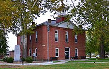
Hickory County courthouse in Hermitage
|
|

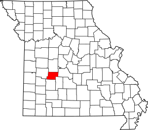
Location within the U.S. state of Missouri
|
|
 Missouri's location within the U.S. |
|
| Country | |
| State | |
| Founded | February 14, 1845 |
| Named for | Andrew Jackson, nicknamed "Old Hickory" |
| Seat | Hermitage |
| Largest city | Hermitage |
| Area | |
| • Total | 412 sq mi (1,070 km2) |
| • Land | 399 sq mi (1,030 km2) |
| • Water | 13 sq mi (30 km2) 3.1% |
| Population
(2020)
|
|
| • Total | 8,279 |
| • Density | 20.095/sq mi (7.759/km2) |
| Time zone | UTC−6 (Central) |
| • Summer (DST) | UTC−5 (CDT) |
| Congressional district | 4th |
| Website | Hickory County, Missouri |
Hickory County is a place in the U.S. state of Missouri. In 2020, about 8,279 people lived there. The main town, or county seat, is Hermitage.
The county was started on February 14, 1845. It was named after President Andrew Jackson. People called him "Old Hickory."
Hickory County is home to some important water features. The Pomme de Terre Dam is located near Hermitage. It creates Lake Pomme de Terre by blocking the Pomme de Terre River and Lindley Creek. Part of the larger Truman Reservoir also reaches into the northern part of the county.
Contents
Exploring Hickory County's Land
Hickory County covers about 412 square miles. Most of this area is land, about 399 square miles. The rest, about 13 square miles, is water. This makes it one of the smaller counties in Missouri.
Neighboring Counties
Hickory County shares its borders with several other counties:
- Benton County (to the north)
- Camden County (to the east)
- Dallas County (to the southeast)
- Polk County (to the south)
- St. Clair County (to the west)
Main Roads in Hickory County
Several important highways run through Hickory County, helping people travel around:
Who Lives in Hickory County?
The number of people living in Hickory County has changed over the years.
| Historical population | |||
|---|---|---|---|
| Census | Pop. | %± | |
| 1850 | 2,329 | — | |
| 1860 | 4,705 | 102.0% | |
| 1870 | 6,452 | 37.1% | |
| 1880 | 7,387 | 14.5% | |
| 1890 | 9,453 | 28.0% | |
| 1900 | 9,985 | 5.6% | |
| 1910 | 8,741 | −12.5% | |
| 1920 | 7,033 | −19.5% | |
| 1930 | 6,430 | −8.6% | |
| 1940 | 6,506 | 1.2% | |
| 1950 | 5,387 | −17.2% | |
| 1960 | 4,516 | −16.2% | |
| 1970 | 4,481 | −0.8% | |
| 1980 | 6,367 | 42.1% | |
| 1990 | 7,335 | 15.2% | |
| 2000 | 8,940 | 21.9% | |
| 2010 | 9,627 | 7.7% | |
| 2020 | 8,279 | −14.0% | |
| U.S. Decennial Census 1790-1960 1900-1990 1990-2000 2010-2015 |
|||
In 2020, the population of Hickory County was 8,279 people. Most residents are White. A small number of people are Native American, Asian, or Black. Some people are also of Hispanic or Latino background.
The average age of people in the county is around 50 years old. About 19.9% of the population is under 18 years old.
Learning and Schools
Hickory County has several public school districts. These schools help students from kindergarten through high school.
Public Schools in the County
- Hermitage R-IV School District in Hermitage
- Hermitage Elementary School (grades PK-5)
- Hermitage Middle School (grades 6-8)
- Hermitage High School (grades 9-12)
- Hickory County R-I School District in Urbana
- Skyline Elementary School (grades K-4)
- Skyline Middle School (grades 5-8)
- Skyline High School (grades 9-12)
- Weaubleau R-III School District in Weaubleau
- Weaubleau Elementary School (grades PK-6)
- Weaubleau High School (grades 7-12)
- Wheatland R-II School District
- Wheatland Elementary School (grades PK-6)
- Wheatland High School (grades 7-12)
Public Libraries
The Hickory County Library provides books and resources for everyone in the community.
Towns and Villages
Hickory County has several towns and smaller communities.
Cities and Towns
- Cross Timbers
- Hermitage (This is the county seat)
- Preston
- Weaubleau
- Wheatland
Smaller Communities
These are smaller places that are not officially cities or towns:
Famous People from Hickory County
- Mike Parson – He served as the 57th Governor of Missouri.
- Sally Rand – A well-known dancer.
See also
 In Spanish: Condado de Hickory para niños
 | Aaron Henry |
 | T. R. M. Howard |
 | Jesse Jackson |

