Polk County, Missouri facts for kids
Quick facts for kids
Polk County
|
|
|---|---|

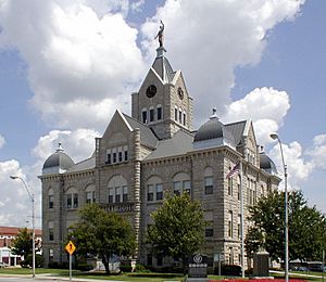
Polk County Courthouse in Bolivar
|
|

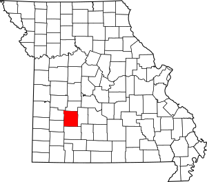
Location within the U.S. state of Missouri
|
|
 Missouri's location within the U.S. |
|
| Country | |
| State | |
| Founded | March 13, 1835 |
| Named for | Ezekiel Polk |
| Seat | Bolivar |
| Largest city | Bolivar |
| Area | |
| • Total | 642 sq mi (1,660 km2) |
| • Land | 636 sq mi (1,650 km2) |
| • Water | 6.9 sq mi (18 km2) 1.1% |
| Population
(2020)
|
|
| • Total | 31,519 |
| • Estimate
(2023)
|
31,519 |
| • Density | 49.10/sq mi (18.956/km2) |
| Time zone | UTC−6 (Central) |
| • Summer (DST) | UTC−5 (CDT) |
| Congressional district | 4th |
Polk County is a county located in the southwestern part of Missouri, a state in the United States. In 2020, about 31,519 people lived here. The main town and county seat (where the county government is) is Bolivar. Polk County was officially created on January 5, 1835. It was named after Ezekiel Polk. This county is also part of the larger Springfield metropolitan area.
Contents
History of Polk County
Polk County was formed from Greene County on January 5, 1835. A small change to its borders happened on March 13, 1835. Over time, parts of Polk County were used to create other nearby counties. These new counties included Dade, Dallas, and Hickory counties.
The county was named to honor Colonel Ezekiel Polk from Tennessee. He was a soldier who served with General George Washington. Ezekiel Polk was also the grandfather of John Polk Campbell and Ezekiel Madison Campbell. These brothers helped to settle the areas that became Polk and Greene counties. Interestingly, Ezekiel Polk was also the grandfather of James K. Polk. James K. Polk was a member of the U.S. House of Representatives in 1835. He later became the President of the United States in 1844.
Polk County Geography
Polk County covers a total area of about 642 square miles. Most of this area, about 636 square miles, is land. The remaining 6.9 square miles, which is about 1.1% of the total, is water.
Counties Next to Polk County
Polk County shares its borders with several other counties:
- Hickory County (to the north)
- Dallas County (to the east)
- Greene County (to the south)
- Dade County (to the southwest)
- Cedar County (to the west)
- St. Clair County (to the northwest)
Main Roads in Polk County
These are some of the important highways that run through Polk County:
Public Transportation
- Jefferson Lines
Polk County Population
| Historical population | |||
|---|---|---|---|
| Census | Pop. | %± | |
| 1840 | 8,449 | — | |
| 1850 | 6,186 | −26.8% | |
| 1860 | 9,995 | 61.6% | |
| 1870 | 12,445 | 24.5% | |
| 1880 | 15,734 | 26.4% | |
| 1890 | 20,339 | 29.3% | |
| 1900 | 23,255 | 14.3% | |
| 1910 | 21,561 | −7.3% | |
| 1920 | 20,351 | −5.6% | |
| 1930 | 17,803 | −12.5% | |
| 1940 | 17,400 | −2.3% | |
| 1950 | 16,062 | −7.7% | |
| 1960 | 13,753 | −14.4% | |
| 1970 | 15,415 | 12.1% | |
| 1980 | 18,822 | 22.1% | |
| 1990 | 21,826 | 16.0% | |
| 2000 | 26,992 | 23.7% | |
| 2010 | 31,137 | 15.4% | |
| 2020 | 31,519 | 1.2% | |
| U.S. Decennial Census 1790-1960 1900-1990 1990-2000 2010 |
|||
The word "demographics" means studying the population of a place. This includes things like how many people live there and their ages.
In 2000, there were 26,992 people living in Polk County. There were 9,917 households and 7,140 families. The population density was about 42 people per square mile. The average household had about 2.56 people. The average family had about 3.02 people.
About 25.7% of the people were under 18 years old. About 12.6% were between 18 and 24 years old. People aged 65 or older made up about 15.3% of the population. The median age was 35 years old. This means half the people were younger than 35 and half were older.
2020 Census Information
In the 2020 census, the total population of Polk County was 31,519 people.
| Race | Number of People | Percentage |
|---|---|---|
| White (Not Hispanic) | 28,682 | 91% |
| Black or African American (Not Hispanic) | 242 | 0.76% |
| Native American (Not Hispanic) | 190 | 0.6% |
| Asian (Not Hispanic) | 131 | 0.42% |
| Pacific Islander (Not Hispanic) | 4 | 0.01% |
| Other/Mixed (Not Hispanic) | 1,479 | 4.7% |
| Hispanic or Latino | 791 | 2.51% |
Education in Polk County
Public Libraries
- Polk County Public Library
Media in Polk County
The local newspaper, The Bolivar Herald-Free Press, is published two times a week.
Communities in Polk County
Polk County has several different types of communities:
Cities
- Bolivar (This is the county seat)
- Fair Play
- Humansville
- Morrisville
- Pleasant Hope
Villages
- Aldrich
- Flemington
- Goodnight (from 2003 to 2016)
- Halfway
Unincorporated Communities
These are smaller places that are not officially organized as cities or villages.
Townships
Polk County is divided into 22 townships, which are smaller areas used for local government:
- Campbell Township
- Cliquot Township
- East Looney Township
- East Madison Township
- Flemington Township
- Jackson Township
- Jefferson Township
- Johnson Township
- McKinley Township
- Mooney Township
- North Benton Township
- North Green Township
- Northeast Marion Township
- Northwest Marion Township
- South Benton Township
- South Green Township
- Southeast Marion Township
- Southwest Marion Township
- Union Township
- West Looney Township
- West Madison Township
- Wishart Township
See also
 In Spanish: Condado de Polk (Misuri) para niños
 | Laphonza Butler |
 | Daisy Bates |
 | Elizabeth Piper Ensley |

