Greene County, Missouri facts for kids
Quick facts for kids
Greene County
|
|
|---|---|

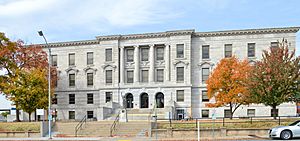
The Historic Greene County Courthouse in Springfield
|
|

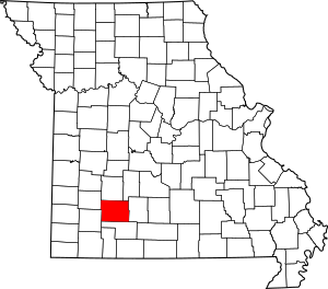
Location within the U.S. state of Missouri
|
|
 Missouri's location within the U.S. |
|
| Country | |
| State | |
| Founded | January 2, 1833 |
| Named for | Nathanael Greene |
| Seat | Springfield |
| Largest city | Springfield |
| Area | |
| • Total | 678 sq mi (1,760 km2) |
| • Land | 675 sq mi (1,750 km2) |
| • Water | 2.6 sq mi (7 km2) 0.4% |
| Population
(2020)
|
|
| • Total | 298,915 |
| • Estimate
(2021)
|
300,865 |
| • Density | 440.9/sq mi (170.22/km2) |
| Time zone | UTC−6 (Central) |
| • Summer (DST) | UTC−5 (CDT) |
| Congressional district | 7th |
Greene County is a cool place located in the southwest part of Missouri. It's like a big neighborhood with lots of people! In 2020, almost 300,000 people lived here, making it the fourth most-populated county in Missouri.
The main city and where the county government is located is Springfield. Greene County was started way back in 1833. It's named after a brave general from the American Revolutionary War, Nathanael Greene. This county is also part of the larger Springfield area. You'll find it in the beautiful Ozark Mountains and their rolling hills.
Contents
Exploring Greene County's Geography
Greene County covers a total area of about 678 square miles. Most of this is land, with only a small part (about 0.4%) being water.
Neighboring Counties Around Greene County
Greene County shares its borders with several other counties. Think of them as its neighbors!
- Polk County (to the north)
- Dallas County (to the northeast)
- Webster County (to the east)
- Christian County (to the south)
- Lawrence County (to the southwest)
- Dade County (to the northwest)
Special Protected Areas: Wilson's Creek Battlefield
One important historical spot in Greene County is Wilson's Creek National Battlefield. This area is protected because it was the site of a major battle during the American Civil War. It's a great place to learn about history!
Understanding Greene County's Population Changes
The number of people living in Greene County has grown a lot over the years. Here's a quick look at how the population has changed:
| Historical population | |||
|---|---|---|---|
| Census | Pop. | %± | |
| 1840 | 5,372 | — | |
| 1850 | 12,785 | 138.0% | |
| 1860 | 13,186 | 3.1% | |
| 1870 | 21,549 | 63.4% | |
| 1880 | 28,801 | 33.7% | |
| 1890 | 48,616 | 68.8% | |
| 1900 | 52,713 | 8.4% | |
| 1910 | 63,831 | 21.1% | |
| 1920 | 68,698 | 7.6% | |
| 1930 | 82,929 | 20.7% | |
| 1940 | 90,541 | 9.2% | |
| 1950 | 104,923 | 15.9% | |
| 1960 | 126,276 | 20.4% | |
| 1970 | 152,929 | 21.1% | |
| 1980 | 185,302 | 21.2% | |
| 1990 | 207,949 | 12.2% | |
| 2000 | 240,391 | 15.6% | |
| 2010 | 275,174 | 14.5% | |
| 2020 | 298,915 | 8.6% | |
| 2021 (est.) | 300,865 | 9.3% | |
| U.S. Decennial Census 1790-1960 1900-1990 1990-2000 2010-2020 |
|||
In 2020, the county had 298,915 people. The population is made up of many different groups, making it a diverse place to live.
Emergency Services in Greene County
Greene County has important services to keep everyone safe.
- Fire departments are in cities like Republic and Springfield.
- Other fire districts also help out, including Ash Grove, Battlefield, Bois D'arc, Brookline, Ebenezer, Fair Grove, Logan-Rogersville, Strafford, Walnut Grove, West Republic, and Willard.
- The Greene County Sheriffs Office handles law enforcement. The current sheriff is Jim C. Arnott.
Learning and Education in Greene County
Greene County has many schools and colleges for students of all ages.
School Districts Serving Greene County
Here are some of the school districts in the county:
- Ash Grove R-IV School District
- Fair Grove R-X School District
- Logan-Rogersville R-VIII School District
- Marion C. Early R-V School District
- Nixa School District
- Pleasant Hope R-VI School District
- Republic R-III School District
- Springfield R-XII School District
- Strafford R-VI School District
- Walnut Grove R-V School District
- Willard R-II School District
Public Schools for All Ages
Greene County has many public schools, from elementary to high school. Here are some examples:
- Ash Grove R-IV School District in Ash Grove has elementary and high schools.
- Fair Grove R-X School District in Fair Grove includes elementary, middle, and high schools.
- Logan-Rogersville R-VIII School District in Rogersville has schools for all grades, including Logan-Rogersville High School.
- Republic R-III School District in Republic has several elementary schools, a middle school, and a high school.
- Springfield R-XII School District in Springfield is a large district with many elementary, middle, and high schools like Parkview, Kickapoo, Hillcrest, Glendale, and Central High Schools.
- Strafford R-VI School District in Strafford offers early childhood, elementary, middle, and high school options.
- Walnut Grove R-V School District in Walnut Grove has preschool, elementary, and high school.
- Willard R-II School District in Willard has multiple elementary schools, an intermediate school, a middle school, and a high school.
Private Schools for Different Learning Styles
There are also many private schools in Springfield, offering different types of education:
- Christian Schools of Springfield (PK-12)
- Grace Classical Academy (PK-12)
- Greenwood Laboratory School (K-12)
- Immaculate Conception School (PK-8)
- New Covenant Academy (PK-12)
- Springfield Catholic High School (09-12)
- Springfield Lutheran School (PS-8)
- St. Agnes Cathedral School (PK-8)
- St. Elizabeth Ann Seton School (PK-5)
- The Summit Preparatory School of Southwest Missouri (PK-12)
Colleges and Universities for Higher Education
After high school, students can attend many colleges and universities in Greene County, mostly in Springfield:
- Missouri State University (a large public university)
- Evangel University (a private university)
- Drury University (a private university)
- Mission University (a private Bible college)
- Ozarks Technical Community College (a public two-year college)
- Everest College (a private college)
- Columbia College Springfield Campus (a private college)
- Bryan University Springfield Campus (a private university)
- Cox College (a nursing college)
- University of Missouri Springfield Clinical Campus (part of the University of Missouri system)
Public Libraries for Reading and Research
- The Springfield-Greene County Library system provides books, resources, and programs for everyone in the community.
Getting Around Greene County: Transportation
Greene County has many ways to travel, from major highways to public transit.
Main Roads and Highways
Major roads help people travel easily through Greene County:
 Interstate 44
 U.S. Route 60
 U.S. Route 65
 U.S. Route 66 (a famous historic road)
 U.S. Route 160
 Route 13
 Route 125
 Route 266
 Route 360
 Route 413
 Route 744
Public Transit and Bus Services
- City Utilities of Springfield and Springfield Transit Services offer local bus routes.
- Long-distance bus services like Greyhound Lines and Jefferson Lines also serve the area.
Airports for Travel
- Springfield-Branson National Airport is the main airport for bigger flights.
- Springfield Downtown Airport is also available for smaller planes.
Communities in Greene County
Greene County is home to several cities, towns, and smaller communities.
Cities and Towns to Explore
- Ash Grove
- Battlefield
- Fair Grove
- Republic
- Rogersville
- Springfield (the county seat)
- Strafford
- Walnut Grove
- Willard
Smaller Unincorporated Communities
These are smaller areas that are not officially cities or towns:
Notable People from Greene County
Many interesting people have come from or lived in Greene County. You can find a longer list here: List of People from Springfield, Missouri
See also
 In Spanish: Condado de Greene (Misuri) para niños
 | William L. Dawson |
 | W. E. B. Du Bois |
 | Harry Belafonte |

