Wilson's Creek National Battlefield facts for kids
Quick facts for kids Wilson's Creek National Battlefield |
|
|---|---|
|
IUCN Category III (Natural Monument)
|
|
 |
|
| Location | Greene County, Missouri, USA |
| Nearest city | Republic, Missouri |
| Area | 2,433 acres (9.85 km2) |
| Established | April 22, 1960 |
| Governing body | National Park Service |
| Website | Wilson's Creek National Battlefield |
|
Wilson's Creek National Battlefield
|
|
| NRHP reference No. | 66000113 (original) 100009403 (increase) |
| Significant dates | |
| Added to NRHP | October 15, 1966 |
| Boundary increase | September 16, 2024 |
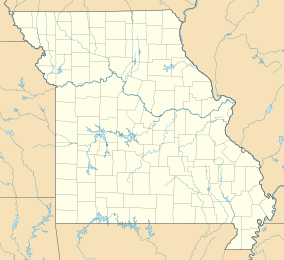
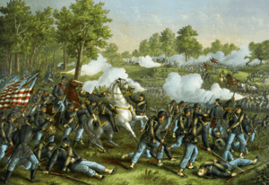
Wilson's Creek National Battlefield is a special place near Republic, Missouri. It protects the land where the Battle of Wilson's Creek happened. This battle took place on August 10, 1861. It was the first big fight of the American Civil War west of the Mississippi River.
In this battle, soldiers from the Confederate side won. Their army was led by Benjamin McCulloch and Sterling Price. They fought against a smaller Union army led by Nathaniel Lyon. Even though the Confederates won this battle, they could not keep control of much of Missouri. Later, the Union won the Battle of Pea Ridge. This win helped the Union keep control of Missouri.
Today, the battlefield has a five-mile driving tour. You can also visit the old 1852 Ray House. "Bloody Hill" is another important spot. This is where the last part of the battle happened. The battlefield is managed by the National Park Service. It became a national site in 1960. It was added to the National Register of Historic Places in 1966.
Contents
The Battle of Wilson's Creek: A Key Civil War Fight
In early 1861, the United States was divided. President Abraham Lincoln asked Missouri to send soldiers to fight for the Union. But Missouri's governor, Claiborne F. Jackson, supported the Confederates. He refused Lincoln's request. Instead, he planned to use the Missouri State Guard to take a U.S. government weapons store in St. Louis, Missouri.
Union General Lyon's Actions
Union General Nathaniel Lyon acted quickly. He stopped the pro-Confederate Guard. He also removed Governor Jackson from power. The Missouri State Guard, now led by Sterling Price, moved towards Springfield. Lyon and his Union army followed them.
The Battle Begins
Price's forces soon got help from a small Confederate army. This army was led by Benjamin McCulloch. On August 10, General Lyon decided to attack. The Confederates were camped along Wilson's Creek. Lyon split his army, even though he had fewer soldiers. He and Colonel Franz Sigel planned to attack the Confederate camp from two sides.
Bloody Hill and Lyon's Death
Colonel Sigel's group was quickly forced to retreat. This allowed Price and McCulloch to combine their forces. They then focused on Lyon's soldiers. Lyon's men had taken a position on a place called Bloody Hill. During the intense fighting, General Lyon was killed. The Union forces then had to retreat. This battle was the first major Civil War fight west of the Mississippi River.
After the Battle
After the battle, Price and McCulloch disagreed about who was in charge. Price moved his troops towards Kansas. He worried about Union soldiers there. McCulloch's army became smaller. Many soldiers' enlistments ended, and some were sent to other places.
Price then moved north and won the Siege of Lexington. But when he heard Union troops were coming, he retreated to Springfield. In March of the next year, Price and McCulloch fought again. They were part of a larger Confederate army at the Battle of Pea Ridge, Arkansas. The Confederates lost this battle, and McCulloch was killed. The defeat at Pea Ridge meant the Confederates could not hold Missouri.
Wilson's Creek National Battlefield: A Place to Learn
The battle site became Wilson's Creek National Battlefield Park on April 22, 1960. It was renamed a National Battlefield on December 16, 1970. The battlefield was added to the National Register of Historic Places on October 15, 1966.
Park Expansion and Preservation
The park has grown over the years. In 2004, 615 acres were added. In 2018, another 60 acres were added. This land was bought by the American Battlefield Trust. The park is near Republic, Missouri, southwest of Springfield. The American Battlefield Trust has helped save 278 acres of the battlefield. Most of this land has been added to the park. In total, the park now protects 1,750 acres of the historic battlefield.
Exploring the Battlefield: What to See and Do
The battlefield is open every day from 8 a.m. to 5 p.m. It has a visitor center. Here you can see exhibits about the battle. There is also a short film and maps. A bookstore is available too.
The Tour Loop and Trails
You can drive a five-mile tour loop through the battlefield. This loop has eight stops. Each stop highlights an important part of the battle. There are also hiking trails. A seven-mile horseback riding trail is available for riders. Every year on August 10, the park holds events to remember the battle.
Historic Buildings and Monuments
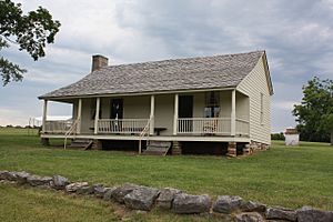
The Ray House is still on the battlefield. It was built before the Civil War. After the battle, it was used as a hospital. General Lyon's body was brought here by Confederate soldiers. You can tour the house during summer hours.
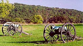
The tour loop also stops at Bloody Hill. This was a place of very heavy fighting. It is also where General Lyon died. A monument marks the spot where he fell. It was put there in 1928. You can also see several old cannons on display at Bloody Hill.
Research and Museum Facilities
Beyond the main tour, the park has more to offer. The John K. and Ruth Hulston Civil War Research Library opened in 1985. It has over 12,000 books about the Civil War. It focuses on the war in the western states. The library also has digital information about Civil War families and soldier groups.
The Wilson's Creek Civil War Museum is also on site. It used to be called the General Sweeny Museum. It displays artifacts and exhibits. These items tell the story of the Civil War in the western United States.
Newtonia: A Nearby Historical Site
In 2022, the Mathew H. Ritchey House was added to Wilson's Creek National Battlefield. This site is about 45 miles away in Newtonia, Missouri. It includes 25 acres from the First Battle of Newtonia and Second Battle of Newtonia. The Old Newtonia Cemetery is also part of it. These sites were added even though the National Park Service felt they were not directly connected to Wilson's Creek.
 | Lonnie Johnson |
 | Granville Woods |
 | Lewis Howard Latimer |
 | James West |


