Republic, Missouri facts for kids
Quick facts for kids
Republic, Missouri
|
|||
|---|---|---|---|
| City of Republic | |||
 |
|||
|
|||

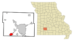
Location of Republic, Missouri
|
|||
| Country | United States | ||
| State | Missouri | ||
| Counties | Christian, Greene | ||
| Incorporated | 1871 | ||
| Area | |||
| • Total | 15.99 sq mi (41.40 km2) | ||
| • Land | 15.99 sq mi (41.40 km2) | ||
| • Water | 0.00 sq mi (0.00 km2) | ||
| Elevation | 1,309 ft (399 m) | ||
| Population
(2020)
|
|||
| • Total | 18,750 | ||
| • Density | 1,172.90/sq mi (452.86/km2) | ||
| Time zone | UTC-6 (Central (CST)) | ||
| • Summer (DST) | UTC-5 (CDT) | ||
| ZIP code |
65738
|
||
| Area code(s) | 417 | ||
| FIPS code | 29-61238 | ||
| GNIS feature ID | 0725224 | ||
| Website | republicmo.com | ||
Republic is a city in Missouri, a state in the United States. It is located in both Christian and Greene counties. In 2020, about 18,750 people lived there. Republic is the second largest city in Greene County. It is also the fourth largest city in the Springfield Metropolitan Area.
Contents
History of Republic, Missouri
Early settlers in southwest Greene County first lived in a community called Little York. When the Atlantic & Pacific Railroad built a train line in the 1870s, Little York was not on the route. So, people moved two miles away to Brookline, which was on the new train line.
Another group of settlers decided to live along the tracks, about four miles southwest of Brookline. This new village became known as Republic. It officially became a city in 1871. Even though the railroad went through Republic, there was no train station or switch at first. People raised $1000 to build a station. The city grew a lot after the station was built.
Republic and Brookline Join Together
In 2005, the cities of Republic and Brookline decided to join together. Residents from both communities voted to approve this. Republic took over all parts of city government. At first, Brookline was supposed to keep its own identity. However, the city limit signs were later changed to say Republic.
Even though Brookline is no longer an independent city, its post office and ZIP Code (65619) are still used. Also, the BNSF Railway still lists Brookline as a stop on its train maps.
Geography and Location
Republic is located at 37°7′18″N 94°28′17″W / 37.12167°N 94.47139°W. The city covers about 13.31 square miles (34.47 square kilometers). Most of this area is land, with only a tiny bit of water. Most of Republic is in Greene County, but a small part is in Christian County.
Population Changes Over Time
| Historical population | |||
|---|---|---|---|
| Census | Pop. | %± | |
| 1880 | 81 | — | |
| 1890 | 381 | 370.4% | |
| 1900 | 856 | 124.7% | |
| 1910 | 884 | 3.3% | |
| 1920 | 1,097 | 24.1% | |
| 1930 | 841 | −23.3% | |
| 1940 | 790 | −6.1% | |
| 1950 | 965 | 22.2% | |
| 1960 | 1,519 | 57.4% | |
| 1970 | 2,411 | 58.7% | |
| 1980 | 4,485 | 86.0% | |
| 1990 | 6,292 | 40.3% | |
| 2000 | 8,438 | 34.1% | |
| 2010 | 14,751 | 74.8% | |
| 2020 | 18,750 | 27.1% | |
| U.S. Decennial Census | |||
Republic's Population in 2020
The 2020 United States census counted 18,750 people living in Republic. There were 6,594 households and 4,620 families. The city had about 1,172.6 people per square mile (452.9/km2). Most residents, about 87.88%, were white. Other groups included black or African-American (1.31%), Native American (0.61%), and Asian (0.81%). About 3.9% of the population was Hispanic or Latino.
About 40.4% of households had children under 18. Many households (44.4%) were married couples. The average household had 2.5 people, and the average family had 2.9 people.
About 27.2% of the population was under 18 years old. The average age in the city was 31.2 years.
Republic's Population in 2010
In 2010, the census showed 14,751 people living in Republic. There were 5,516 households and 3,999 families. The city had about 1,109.1 people per square mile (428.2/km2). Most people (95.6%) were White. About 2.2% of the population was Hispanic or Latino.
About 42.3% of households had children under 18. The average household size was 2.64 people, and the average family size was 3.09 people.
The average age in the city was 32.2 years. About 29.6% of residents were under 18.
Getting Around Republic: Transportation
Republic is located on U.S. Highway 60. This highway runs with Missouri Route 413 through the city. Interstate 44 is just north of the city limits. Missouri Route 360, also known as James River Freeway, starts near I-44 and goes east.
The city is served by the BNSF Railway. This railway line goes through Republic on its way between Tulsa, Oklahoma, and Memphis, Tennessee. This route is important for connecting California with cities like Birmingham and Atlanta. Trains mostly carry goods and large shipping containers. Passenger trains stopped running through Republic in 1967.
Schools and Learning in Republic
Local Schools for Kids and Teens
Republic is part of the Republic School District. The district has several schools:
- Republic High School
- Republic Middle School
- Lyon Elementary
- McCulloch Elementary
- Price Elementary
- Schofield Elementary
- Sweeny Elementary
- Republic Early Childhood Center
Students in middle and high school can join many sports and activities. These include football, volleyball, band, choir, academic clubs, and robotics.
Higher Education Opportunities
Ozarks Technical Community College opened its Republic Center in August 2020. This center is a smaller campus that offers many different degree programs. It helps students in Republic and nearby areas get a college education.
Notable People from Republic
- Charles Harrison Brown: He served as a U.S. representative for Missouri from 1957 to 1961.
- Ross Carter: An American football player.
- Stephen R. Bough: A Federal Judge in the Western District of Missouri.
See also
 In Spanish: Republic (Misuri) para niños
 | Misty Copeland |
 | Raven Wilkinson |
 | Debra Austin |
 | Aesha Ash |


