Strafford, Missouri facts for kids
Quick facts for kids
Strafford, Missouri
|
|
|---|---|
| City of Strafford | |

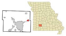
Location of Strafford, Missouri
|
|
| Country | United States |
| State | Missouri |
| County | Greene, Webster |
| Area | |
| • Total | 300.29 sq mi (8.52 km2) |
| • Land | 300 sq mi (8.52 km2) |
| • Water | 0.00 sq mi (0.00 km2) |
| Elevation | 1,490 ft (454 m) |
| Population
(2020)
|
|
| • Total | 2,561 |
| • Density | 778.42/sq mi (300.52/km2) |
| Time zone | UTC-6 (Central (CST)) |
| • Summer (DST) | UTC-5 (CDT) |
| ZIP code |
65757
|
| Area code(s) | 417 |
| FIPS code | 29-71062 |
| GNIS feature ID | 0727168 |
Strafford is a city located in Greene County, Missouri. A small part of the city also reaches into Webster County. It is part of the larger Springfield Metropolitan Area. In 2020, about 2,561 people lived in Strafford.
Contents
History of Strafford
Strafford was officially started in 1870. This happened when a railroad line was built through the area. The city was named after one of the first owners of the land. A post office has been open in Strafford since 1870.
Unique Street Design
According to Ripley's Believe It or Not!, Strafford is quite special. It is the only town in the United States with two main streets but no back alleys. The original main street was to the north. Later, Route 66 was built right behind the businesses. Instead of having back alleys, owners simply built new entrances facing Route 66. This gave their shops two front doors!
Geography of the City
Strafford covers an area of about 2.63 square miles (6.81 square kilometers). All of this area is land. There are no large bodies of water within the city limits.
Historical Roads
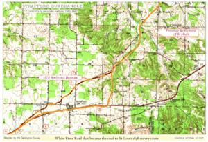
Old maps from the 1800s show that Strafford was built along the White River Road. This road later became known as the Telegraph Road to Saint Louis.
Population and People
The number of people living in Strafford has grown over the years. Here's how the population has changed:
| Historical population | |||
|---|---|---|---|
| Census | Pop. | %± | |
| 1970 | 491 | — | |
| 1980 | 1,121 | 128.3% | |
| 1990 | 1,166 | 4.0% | |
| 2000 | 1,845 | 58.2% | |
| 2010 | 2,358 | 27.8% | |
| 2020 | 2,561 | 8.6% | |
| U.S. Decennial Census | |||
Life in Strafford: 2010 Census
In 2010, there were 2,358 people living in Strafford. They lived in 867 households. About 636 of these were families.
- Homes and Families:
- About 40.8% of households had children under 18 living there.
- Most households (54.1%) were married couples living together.
- Some households (14.3%) had a female head with no husband.
- About 26.6% of households were not families.
- Age Groups:
- The average age in the city was 34.2 years old.
- About 28.8% of residents were under 18.
- About 12.4% of residents were 65 years or older.
- Diversity:
- Most people (95.8%) identified as White.
- A small number of people identified as African American, Native American, or Asian.
- About 1.9% of the population was Hispanic or Latino.
See also
 In Spanish: Strafford (Misuri) para niños
 | Dorothy Vaughan |
 | Charles Henry Turner |
 | Hildrus Poindexter |
 | Henry Cecil McBay |


