Battlefield, Missouri facts for kids
Quick facts for kids
Battlefield, Missouri
|
|
|---|---|
| City of Battlefield | |

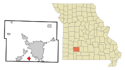
Location of Battlefield, Missouri
|
|
| Country | United States |
| State | Missouri |
| County | Greene |
| Area | |
| • Total | 2.56 sq mi (6.63 km2) |
| • Land | 2.56 sq mi (6.63 km2) |
| • Water | 0.00 sq mi (0.00 km2) |
| Elevation | 1,273 ft (388 m) |
| Population
(2020)
|
|
| • Total | 5,990 |
| • Density | 2,338.93/sq mi (903.20/km2) |
| Time zone | UTC-6 (Central (CST)) |
| • Summer (DST) | UTC-5 (CDT) |
| ZIP code |
65619
|
| Area code(s) | 417 |
| FIPS code | 29-03592 |
Battlefield is a city located in Greene County, Missouri, in the United States. In 2020, about 5,990 people lived there. It is part of the larger Springfield area. Interestingly, Battlefield does not have its own post office. It shares a ZIP code (65619) with a nearby town called Brookline.
Contents
Discovering Battlefield's Past
The city of Battlefield got its name because it is very close to the site of the Battle of Wilson's Creek. This battle happened in 1861 and was one of the first major fights of the American Civil War. A post office was opened in Battlefield in 1908. It served the community until 1940.
Geography and Location
Battlefield is found in the southern part of Greene County. It is about 1.5 miles north of the line that divides Greene and Christian counties. Missouri Route FF is a road that goes right through the community. Two miles west of the town, you can find Wilsons Creek and the Wilson's Creek National Battlefield.
The United States Census Bureau reports that the city covers a total area of about 2.50 square miles (6.47 square kilometers). All of this area is land.
Who Lives in Battlefield?
| Historical population | |||
|---|---|---|---|
| Census | Pop. | %± | |
| 1980 | 1,227 | — | |
| 1990 | 1,526 | 24.4% | |
| 2000 | 2,385 | 56.3% | |
| 2010 | 5,590 | 134.4% | |
| 2020 | 5,990 | 7.2% | |
| U.S. Decennial Census | |||
Population in 2010
Based on the census from 2010, there were 5,590 people living in Battlefield. These people lived in 2,125 households, and 1,593 of these were families. The city had about 2,236 people per square mile (863 people per square kilometer). There were 2,210 homes, with about 884 homes per square mile (341 homes per square kilometer).
Most people in the city were White (92.8%). Other groups included African American (1.5%), Native American (0.5%), and Asian (2.1%). Some people (0.7%) were from other races, and 2.4% were from two or more races. About 2.7% of the population identified as Hispanic or Latino.
Households and Families
Out of the 2,125 households:
- 40.6% had children under 18 living with them.
- 62.3% were married couples living together.
- 9.0% had a female head of household with no husband.
- 3.6% had a male head of household with no wife.
- 25.0% were not families.
About 20.4% of all households were made up of individuals living alone. Only 4% had someone living alone who was 65 years or older. On average, each household had 2.63 people, and each family had 3.05 people.
Age of Residents
The average age of people in Battlefield was 33.8 years.
- 29.2% of residents were under 18 years old.
- 5.7% were between 18 and 24 years old.
- 33.7% were between 25 and 44 years old.
- 22.6% were between 45 and 64 years old.
- 8.7% were 65 years or older.
The city had slightly more females (51.4%) than males (48.6%).
Education in Battlefield
The schools in Battlefield are divided between two different school districts. Some students attend schools in the Springfield R-XII School District, while others go to schools in the Republic R-III School District.
See also
 In Spanish: Battlefield (Misuri) para niños
 | Emma Amos |
 | Edward Mitchell Bannister |
 | Larry D. Alexander |
 | Ernie Barnes |

