St. Clair County, Missouri facts for kids
Quick facts for kids
St. Clair County
|
|
|---|---|

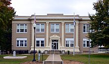
St. Clair County courthouse in Osceola
|
|

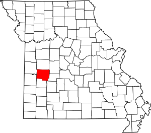
Location within the U.S. state of Missouri
|
|
 Missouri's location within the U.S. |
|
| Country | |
| State | |
| Founded | January 29, 1841 |
| Named for | Arthur St. Clair |
| Seat | Osceola |
| Largest city | Appleton City |
| Area | |
| • Total | 702 sq mi (1,820 km2) |
| • Land | 670 sq mi (1,700 km2) |
| • Water | 32 sq mi (80 km2) 4.6% |
| Population
(2020)
|
|
| • Total | 9,284 |
| • Estimate
(2024)
|
9,848 |
| • Density | 14.7/sq mi (5.7/km2) |
| Time zone | UTC−6 (Central) |
| • Summer (DST) | UTC−5 (CDT) |
| Congressional district | 4th |
St. Clair County is a county located in the western part of Missouri, a state in the United States. As of the 2020 census, about 9,284 people lived there. The main town, or county seat, is Osceola. The biggest city in the county is Appleton City.
St. Clair County was created in 1841. It was named after General Arthur St. Clair. He was an important leader and governor of the Northwest Territory a long time ago. He also served as the 9th president of the United States in Congress Assembled. During his time, important laws like the Northwest Ordinance and the United States Constitution were passed.
Contents
Exploring St. Clair County's Geography
St. Clair County covers a total area of about 702 square miles. Most of this area, about 670 square miles, is land. The remaining 32 square miles, which is about 4.6% of the county, is covered by water.
Neighboring Counties
St. Clair County shares its borders with several other counties:
- Henry County (to the north)
- Benton County (to the northeast)
- Hickory County (to the east)
- Polk County (to the southeast)
- Cedar County (to the south)
- Vernon County (to the southwest)
- Bates County (to the northwest)
Main Roads and Travel
Several important highways run through St. Clair County, making it easy to travel around:
For public transportation, Jefferson Lines also serves the area.
Who Lives in St. Clair County?
The population of St. Clair County has changed over many years.
| Historical population | |||
|---|---|---|---|
| Census | Pop. | %± | |
| 1850 | 3,556 | — | |
| 1860 | 6,812 | 91.6% | |
| 1870 | 6,742 | −1.0% | |
| 1880 | 14,125 | 109.5% | |
| 1890 | 16,747 | 18.6% | |
| 1900 | 17,907 | 6.9% | |
| 1910 | 16,412 | −8.3% | |
| 1920 | 15,341 | −6.5% | |
| 1930 | 13,289 | −13.4% | |
| 1940 | 13,146 | −1.1% | |
| 1950 | 10,482 | −20.3% | |
| 1960 | 8,421 | −19.7% | |
| 1970 | 7,667 | −9.0% | |
| 1980 | 8,622 | 12.5% | |
| 1990 | 8,457 | −1.9% | |
| 2000 | 9,652 | 14.1% | |
| 2010 | 9,805 | 1.6% | |
| 2020 | 9,284 | −5.3% | |
| 2024 (est.) | 9,848 | 0.4% | |
| U.S. Decennial Census 1790–1960 1900–1990 1990–2000 2010–2015 2024 |
|||
In 2020, the county had a population of 9,284 people. The U.S. Census Bureau estimated the population to be around 9,848 people in 2024. This shows how the number of people living in the county has grown and changed over time.
Learning and Libraries in St. Clair County
St. Clair County has several schools and libraries for its young people and residents.
Public Schools in the County
- Appleton City R-II School District – Appleton City
- Appleton City Elementary School (Kindergarten–5th grade)
- Appleton City High School (6th–12th grade)
- Hudson R-IX School District – Appleton City
- Hudson Elementary School (Preschool–8th grade)
- Osceola Public Schools – Osceola
- Osceola Elementary School (Preschool–6th grade)
- Osceola High School (7th–12th grade)
- Roscoe C-1 School District – Roscoe
- Roscoe Elementary School (Preschool–8th grade)
- Lakeland R-III School District – Lowry City & Deepwater
- Lakeland Elementary School
Public Libraries for Everyone
- Appleton City Public Library
- St. Clair County Library-Main Library (Osceola)
- St. Clair County Library-Lowry City Branch
Cities, Villages, and Towns in St. Clair County
St. Clair County is home to several communities, from larger cities to smaller villages and unincorporated areas.
Cities to Explore
- Appleton City
- Lowry City
- Osceola (This is the county seat, where the main government offices are located.)
Charming Villages
Other Communities in the County
County Townships
St. Clair County is divided into 16 smaller areas called townships:
|
|
|
|
See also
In Spanish:  Condado de St. Clair (Misuri) para niños
 | Bessie Coleman |
 | Spann Watson |
 | Jill E. Brown |
 | Sherman W. White |

