Bates County, Missouri facts for kids
Quick facts for kids
Bates County
|
|
|---|---|

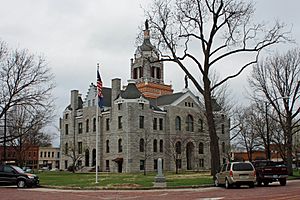
Bates County Courthouse in Butler
|
|

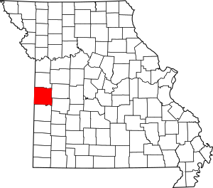
Location within the U.S. state of Missouri
|
|
 Missouri's location within the U.S. |
|
| Country | |
| State | |
| Founded | January 29, 1841 |
| Named for | Frederick Bates |
| Seat | Butler |
| Largest city | Butler |
| Area | |
| • Total | 851 sq mi (2,200 km2) |
| • Land | 837 sq mi (2,170 km2) |
| • Water | 15 sq mi (40 km2) 1.7% |
| Population
(2020)
|
|
| • Total | 16,042 |
| • Density | 18.851/sq mi (7.278/km2) |
| Time zone | UTC−6 (Central) |
| • Summer (DST) | UTC−5 (CDT) |
| Congressional district | 4th |
Bates County is a county in the west central part of Missouri, a state in the United States. It's located south of the Missouri River and is part of the larger Kansas City metropolitan area. In 2020, about 16,042 people lived here.
The county seat, which is the main town where the county government is located, is Butler. Bates County was created in 1841. It was named after Frederick Bates, who was the second Governor of Missouri. This area is mostly rural, meaning it has a lot of farms and open land.
Contents
History of Bates County
The areas near the border of Kansas and Missouri were very important during the American Civil War. Many small battles and raids happened back and forth across the border.
First African-American Soldiers in Combat
Bates County is famous for a special event during the Civil War. It was the site of the first battle where African-American soldiers officially fought for the Union army against Confederate forces. This happened on October 28–29, 1862.
A group called the First Kansas Colored Division, which was part of the state militia, fought against Confederate fighters at the Battle of Island Mound. This battle took place near Rich Hill, Missouri. Even though the Kansas soldiers were greatly outnumbered, they fought bravely and won the skirmish.
The New York Times newspaper wrote about this battle. They highlighted the courage of these soldiers at a time when many people doubted if former slaves could be good fighters. Their brave actions happened before President Abraham Lincoln announced the Emancipation Proclamation in January 1863. This proclamation led to the creation of the United States Colored Troops.
General Order No. 11
In 1863, after Confederate fighters attacked and burned Lawrence, Kansas, a Union General named Ewing gave a special command. This was called Order No. 11. He ordered people living in rural parts of Bates County and nearby areas to leave their homes. They could only stay if they lived within one mile of certain Union-controlled cities.
This order was given to stop local people from helping the Confederate fighters, who were hiding in the county. However, General Ewing's order made many people angry and actually caused more support for the Confederate fighters in some areas.
After the Civil War, Bates County continued to be a farming area. Since the early 1900s, fewer people have lived in the county. Many moved to bigger cities to find work.
Honors and Special Places
Bates County remembers its history with special monuments and preserved sites.
- A statue that honors the Battle of Island Mound is located on the lawn of the county courthouse in Butler. This is about seven miles from where the battle happened.
- The actual battle area has been protected since 2012. It is now called the Battle of Island Mound State Historic Site. The historic prairie land there is also being restored to its natural state.
- A short movie called The Battle of Island Mound was made in 2014. It won two Emmy Awards in 2015 for being a great historical documentary and for its cinematography (how it was filmed).
Geography of Bates County
Bates County covers a total area of about 851 square miles. Most of this, about 837 square miles, is land. The remaining 15 square miles, or 1.7%, is water.
Neighboring Counties
Bates County shares its borders with several other counties:
- Cass County (to the north)
- Henry County (to the northeast)
- St. Clair County (to the southeast)
- Vernon County (to the south)
- Linn County, Kansas (to the west)
- Miami County, Kansas (to the northwest)
Main Roads
Several important highways pass through Bates County:
 Interstate 49
 U.S. Route 71
 Route 18
 Route 52
Public Transport
- Jefferson Lines (a bus service)
People of Bates County
| Historical population | |||
|---|---|---|---|
| Census | Pop. | %± | |
| 1850 | 3,669 | — | |
| 1860 | 7,215 | 96.6% | |
| 1870 | 15,960 | 121.2% | |
| 1880 | 25,381 | 59.0% | |
| 1890 | 32,223 | 27.0% | |
| 1900 | 30,141 | −6.5% | |
| 1910 | 25,869 | −14.2% | |
| 1920 | 23,933 | −7.5% | |
| 1930 | 22,068 | −7.8% | |
| 1940 | 19,531 | −11.5% | |
| 1950 | 17,534 | −10.2% | |
| 1960 | 15,905 | −9.3% | |
| 1970 | 15,468 | −2.7% | |
| 1980 | 15,873 | 2.6% | |
| 1990 | 15,025 | −5.3% | |
| 2000 | 16,653 | 10.8% | |
| 2010 | 17,049 | 2.4% | |
| 2020 | 16,042 | −5.9% | |
| U.S. Decennial Census 1790-1960 1900-1990 1990-2000 2010-2020 |
|||
In 2000, there were about 16,653 people living in Bates County. There were 6,511 households, which are groups of people living together. The average household had about 2.51 people.
About 26.5% of the population was under 18 years old. The median age, which is the middle age of all the people, was 38 years.
2020 Census Information
The 2020 census showed the following breakdown of people in Bates County:
| Race | Num. | Perc. |
|---|---|---|
| White (NH) | 14,799 | 92.3% |
| Black or African American (NH) | 155 | 1% |
| Native American (NH) | 92 | 0.6% |
| Asian (NH) | 48 | 0.3% |
| Pacific Islander (NH) | 9 | 0.06% |
| Other/Mixed (NH) | 604 | 3.81% |
| Hispanic or Latino | 335 | 2.1% |
Religion in Bates County
Bates County is part of an area sometimes called the "Bible Belt." This means that many people there follow evangelical Protestant religions. The most common religious groups in Bates County are Southern Baptists, United Methodists, and Christian Churches and Churches of Christ.
Education in Bates County
Bates County has several public and private schools, as well as public libraries.
Public Schools
- Adrian
- Adrian Elementary School (grades PK-05)
- Adrian High School (grades 06-12)
- Butler
- Ballard Elementary School (grades PK-06)
- Ballard High School (grades 07-12)
- Butler
- Butler Elementary School (grades K-06)
- Butler High School (grades 07-12)
- Hume
- Hume Elementary School (grades PK-05)
- Hume High School (grades 06-12)
- Amoret
- Miami Elementary School (grades K-06)
- Miami High School (grades 07-12)
- Rich Hill
- Rich Hill Elementary School (grades K-05)
- Rich Hill High School (grades 06-12)
Private Schools
Public Libraries
- Butler Public Library
- Rich Hill Memorial Library
Communities in Bates County
Bates County has several cities, villages, and smaller unincorporated communities.
Cities
Villages
Unincorporated Communities
These are smaller communities that are not officially organized as cities or villages.
Townships
Bates County is divided into 24 smaller areas called townships:
- Charlotte
- Deepwater
- Deer Creek
- East Boone
- Elkhart
- Grand River
- Homer
- Howard
- Hudson
- Lone Oak
- Mingo
- Mound
- Mount Pleasant
- New Home
- Osage
- Pleasant Gap
- Prairie
- Rockville
- Shawnee
- Spruce
- Summit
- Walnut
- West Boone
- West Point
Notable People from Bates County
Several well-known individuals have connections to Bates County:
- Robert Heinlein: A famous science fiction author who was born and lived in Butler. He even mentioned the town in some of his stories.
- Howard Maple: A professional athlete who played both American football and baseball.
- Charles O'Rear: A photographer and author best known for his picture Bliss. This photo was the default background image for Windows XP computers.
- Stan Wall: A former Major League Baseball pitcher who played for the Los Angeles Dodgers.
- Warren Welliver: A Missouri Supreme Court Justice from 1979 to 1989.
See also
 In Spanish: Condado de Bates para niños
 | Emma Amos |
 | Edward Mitchell Bannister |
 | Larry D. Alexander |
 | Ernie Barnes |

