Rich Hill, Missouri facts for kids
Quick facts for kids
Rich Hill, Missouri
|
|
|---|---|
| Nickname(s):
The Town That Coal Built
|
|

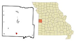
Location of Rich Hill, Missouri
|
|
| Country | United States |
| State | Missouri |
| County | Bates |
| Area | |
| • Total | 1.37 sq mi (3.56 km2) |
| • Land | 1.37 sq mi (3.54 km2) |
| • Water | 0.01 sq mi (0.02 km2) |
| Elevation | 804 ft (245 m) |
| Population
(2020)
|
|
| • Total | 1,232 |
| • Density | 902/sq mi (348/km2) |
| Time zone | UTC-6 (Central (CST)) |
| • Summer (DST) | UTC-5 (CDT) |
| ZIP code |
64779
|
| Area code(s) | 417 |
| FIPS code | 29-61418 |
| GNIS feature ID | 2396361 |
Rich Hill is a city located in the southern part of Bates County, Missouri. It is also part of the larger Kansas City metropolitan area in the United States. In 2020, the city had a population of 1,232 people.
Contents
History of Rich Hill
Rich Hill was officially planned and laid out in 1880. However, the city got its name earlier, in 1871, from C.W. Ratekin. Its nickname, "The Town That Coal Built," shows how important coal mining was to its early growth.
During the late 1800s, Rich Hill grew very quickly because of its coal mines. But by 1906, mining started to slow down and eventually stopped. Later, in the 1950s, a company called Peabody Energy restarted some of the mining operations.
A special place called the Prairie View Stock Farm was added to the National Register of Historic Places in 2015. This means it is an important historical site.
Geography and Location
Rich Hill is situated near Missouri Route A and US Route 71. It is about eleven miles south of Butler. The border between Bates and Vernon counties is just 2.5 miles to the south.
The city is also close to the upper parts of the Truman Reservoir, which is about two miles east on the Marais des Cygnes River.
The United States Census Bureau states that Rich Hill covers a total area of about 1.38 square miles (3.56 square kilometers). Most of this area is land, with only a small part being water.
Population and People
The population of Rich Hill has changed over the years. Here is a look at how many people have lived in the city during different census counts:
| Historical population | |||
|---|---|---|---|
| Census | Pop. | %± | |
| 1890 | 4,008 | — | |
| 1900 | 4,053 | 1.1% | |
| 1910 | 2,755 | −32.0% | |
| 1920 | 2,261 | −17.9% | |
| 1930 | 2,118 | −6.3% | |
| 1940 | 1,994 | −5.9% | |
| 1950 | 1,820 | −8.7% | |
| 1960 | 1,699 | −6.6% | |
| 1970 | 1,661 | −2.2% | |
| 1980 | 1,471 | −11.4% | |
| 1990 | 1,317 | −10.5% | |
| 2000 | 1,461 | 10.9% | |
| 2010 | 1,396 | −4.4% | |
| 2020 | 1,232 | −11.7% | |
| U.S. Decennial Census | |||
What the 2010 Census Showed
In 2010, there were 1,396 people living in Rich Hill. These people lived in 567 households, and 351 of these were families. The city had about 1,019 people per square mile.
Most of the people in Rich Hill were White (95.5%). A small number were African American, Native American, or Asian. Some people identified as being of Hispanic or Latino background.
About 33.2% of households had children under 18 living with them. Many households (45.3%) were married couples. The average household had 2.46 people, and the average family had 3.11 people.
The average age of people in the city was 41 years old. About 27.4% of residents were under 18, and 17% were 65 or older.
Education in Rich Hill
Public schools in Rich Hill are managed by the Rich Hill R-IV School District.
The city also has a public library called the Rich Hill Memorial Library. Libraries are great places to read and learn!
Transportation Options
Bus service to Rich Hill is provided by Jefferson Lines. This company helps people travel between cities.
Rich Hill in Pop Culture
Rich Hill was featured in a 2014 documentary film also called Rich Hill. This movie was shown at the 2014 Sundance Film Festival. It even won a special award there, the U.S. Grand Jury Prize for a documentary.
See also
In Spanish: Rich Hill (Misuri) para niños
 | Delilah Pierce |
 | Gordon Parks |
 | Augusta Savage |
 | Charles Ethan Porter |

