
Lawrence, Kansas facts for kids
Quick facts for kids
Lawrence, Kansas
|
||
|---|---|---|
|
City and county seat
|
||
.jpg)
Douglas County Courthouse (2021)
|
||
|
||
| Nickname(s):
LFK, Larryville
|
||
| Motto(s):
From Ashes to Immortality
|
||

Location within Douglas County and Kansas
|
||

|
||
| Country | United States | |
| State | Kansas | |
| County | Douglas | |
| Founded | 1854 | |
| Incorporated | February 20, 1858 | |
| Named for | Amos A. Lawrence | |
| Government | ||
| • Type | City commission | |
| Area | ||
| • Total | 34.97 sq mi (90.57 km2) | |
| • Land | 34.14 sq mi (88.42 km2) | |
| • Water | 0.83 sq mi (2.14 km2) | |
| Elevation | 991 ft (302 m) | |
| Population
(2020)
|
||
| • Total | 94,934 | |
| • Estimate
(2021)
|
95,256 | |
| • Density | 2,714.7/sq mi (1,048.18/km2) | |
| Time zone | UTC−6 (CST) | |
| • Summer (DST) | UTC−5 (CDT) | |
| ZIP codes |
66044–66047, 66049
|
|
| Area code | 785 | |
| FIPS code | 20-38900 | |
| GNIS ID | 485609 | |
| Interstate highway | I-70 | |
| Public Transportation | Lawrence Transit | |

Lawrence is a city in Kansas, located in the northeastern part of the state. It is the sixth-largest city in Kansas and is the main city of Douglas County, Kansas. Lawrence sits between two rivers, the Kansas River and the Wakarusa River. In 2020, about 94,934 people lived here.
Lawrence is known as a "college town" because it is home to two important universities: the University of Kansas and Haskell Indian Nations University.
The city was started in 1854 by a group called the New England Emigrant Aid Company. It was named after Amos A. Lawrence, who was against slavery and helped fund the settlement. Lawrence played a big role in a tough time in Kansas history called "Bleeding Kansas" (1854–1861). This period included events like the Wakarusa War (1855), the Sacking of Lawrence (1856), and the Lawrence massacre (1863) during the American Civil War.
Lawrence began as a place for people who wanted Kansas to be a free state, meaning no slavery. Over time, its economy grew to include farming, manufacturing, and especially education, thanks to the universities.
Contents
History of Lawrence, Kansas
How Lawrence Began
The Kaw people, also known as the Kansa, lived in this area before it became Lawrence. In the early 1800s, treaties with the U.S. government made them give up their land to the Shawnee people. In 1854, the Kansas Territory was created. The Oregon Trail, a famous path for pioneers, ran through the area where Lawrence is today. A hill called Mount Oread was a key landmark for travelers.
Lawrence was founded for a very important reason: to fight against slavery. In the mid-1800s, there was a big debate in the United States about whether new states should allow slavery. A law called the Kansas–Nebraska Act (1854) said that people in new territories like Kansas could decide for themselves if they wanted slavery. Many people in the North were worried this would lead to Kansas becoming a slave state.
People who were against slavery, called "Free-Staters", decided to move to Kansas. They wanted to vote against slavery and make Kansas a free state. In May 1854, some men explored the area and thought it would be a good place for a settlement.

The New England Emigrant Aid Company (NEEAC) helped these settlers. In July 1854, a group of 29 pioneers left Boston, Massachusetts, to settle in Kansas. They arrived on August 1, 1854, and chose the area between Mount Oread and the Kansas River to build their town.
More settlers arrived in September and October 1854. By September 18, the early colonists had set up their own local government. They wanted their town to be free from slavery. Pro-slavery people threatened them, but the settlers stayed strong.

The first governor of the Kansas Territory, Andrew Horatio Reeder, visited Lawrence in October 1854. Lawrence's first winter was very hard, with people living in simple homes.
By the end of 1854, two newspapers that supported the free-state cause were started in Lawrence: the Herald of Freedom and the Kansas Tribune. A third paper, the Kansas Free State, began in January 1855. The Plymouth Congregational Church was also started in September 1854. The first post office opened in January 1855, and the first school in Kansas was established in Lawrence on January 10, 1855.

The "Bleeding Kansas" Era
In 1855, settlers with different views on slavery moved to Kansas. Secret groups, like the Blue Lodges, formed to try and make Kansas a slave state. This led to many conflicts.
To try and calm things down, Governor Wilson Shannon called for the Kansas militia. However, a sheriff named Samuel Jones gathered an army of 1,200–1,500 pro-slavery men, mostly from Missouri. When the people of Lawrence heard about this, they formed their own defense of 600–800 men. Charles L. Robinson led their military efforts, and James Lane was his second-in-command. Even John Brown, a famous abolitionist, and his four sons helped defend Lawrence.
Both sides were ready to fight, but the harsh winter helped prevent a big battle. On December 8, Governor Shannon ordered both sides to sign a peace treaty. The Missouri army eventually left. This conflict became known as the "Wakarusa War".

In the spring of 1856, pro-slavery groups wanted to weaken the anti-slavery settlers. They targeted the Kansas Free State and Herald of Freedom newspapers, and the Free State Hotel. On April 23, 1856, Sheriff Jones tried to arrest members of the free-state government in Lawrence. During this, Jones was shot, and Lawrence residents forced him out of town. The people of Lawrence did not approve of the shooting and offered a reward for the shooter's arrest.
A few weeks later, on May 21, Sheriff Jones returned with about 800 pro-slavery followers, many from Missouri. Their goal was to enforce arrests and also to destroy Lawrence. They attacked the anti-slavery newspaper offices, smashing their printing presses and throwing the type into the Kansas River. Then, they used a cannon to shoot at the Free State Hotel and burned it down. Jones and his men stole about $30,000 worth of goods. They also set Charles L. Robinson's house on fire.
Even though the city was badly damaged, only one person died during this attack, a member of Jones's group. This event is known as the Sacking of Lawrence. Later in September 1856, another attack was threatened, but the new governor, John W. Geary, called for federal soldiers to protect the city, stopping the attack.
Lawrence as the Anti-Slavery Capital
Lawrence refused to accept charters from the pro-slavery government because they did not want to follow pro-slavery laws. In July 1857, Lawrence tried to get an official city charter from the free-state legislature. This made the new governor, Robert J. Walker, angry, and he sent soldiers to Lawrence to enforce martial law.
By the election of 1857, the free-staters gained control of the Kansas legislature. In early 1858, Samuel Jones, a long-time enemy of Lawrence, left the territory. On January 16, 1858, Lawrence became the official county seat of Douglas County. In February, the legislature approved Lawrence's city charter, and James Blood was elected the first mayor. Lawrence then became the unofficial capital of Kansas Territory from 1858 to 1861.
Kansas Becomes a State and the Civil War

On January 29, 1861, Kansas officially became a free state. This happened right as the American Civil War was beginning.
During the Civil War, Lawrence became a base for Jayhawker groups. These groups raided parts of western Missouri, stealing goods and burning farms. Many Southerners believed these stolen goods were kept in Lawrence.
On August 21, 1863, William Quantrill and hundreds of his Confederate raiders attacked Lawrence. This event is known as the Lawrence Massacre. Most homes and businesses were burned, and between 150 and 200 men and boys were killed. This left 80 widows and 250 orphans. About $2,000,000 worth of property was destroyed. The Plymouth Congregational Church survived the attack.

After the massacre, the people of Lawrence worked hard to rebuild their city. They organized groups to protect the city from future attacks. The government also built military posts on Mount Oread to guard Lawrence. No more attacks happened, and these posts were later taken down after the war.
After the Civil War
_(cropped).jpg)
Plans to start a university in Kansas began in 1855. After Kansas became a state in 1861, the idea for a state university was included in the Kansas Constitution. Lawrence competed with other cities to be the location. Because Amos A. Lawrence had donated $10,000 and 40 acres of land for the university, Lawrence won by one vote. In 1866, the University of Kansas (KU) opened its doors to students.
_(cropped).jpg)
The first railroad connecting Lawrence to Kansas City was built in 1864. The first train arrived in Lawrence on November 28, 1864.

In the 1870s, Lawrence needed more power. A dam was built across the Kansas River to provide energy. This dam, now known as the Bowersock Dam, helped Lawrence become an industrial city. It is still the only hydropower dam in Kansas.
The first wind-powered mill in Kansas was built in Lawrence in 1863. It was damaged during Quantrill's Raid but rebuilt in 1864. It operated until 1885 and was destroyed by fire in 1905.
In 1884, the United States Indian Industrial Training School opened in Lawrence. This school aimed to teach Native American students trades and academic skills. In 1887, it was renamed the Haskell Institute, and in 1993, it became Haskell Indian Nations University.
Lawrence in the 20th Century and Beyond

In 1888, Watkins National Bank opened. The founder's widow, Elizabeth Watkins, later donated the building to the city to be used as a city hall. In 1975, it reopened as the Elizabeth M. Watkins Community Museum.
The Kansas River flooded in 1903, causing damage in Lawrence. Other floods happened in 1951 and 1993, but a reservoir and levee system now protect the city.
President Theodore Roosevelt visited Lawrence in 1903 and again in 1910.
A horse-drawn streetcar system started in Lawrence in 1871. It closed after the 1903 flood damaged the bridge. A new streetcar system was put in place in 1909 and lasted until 1935.
Lawrence Memorial Hospital opened in 1921 with 50 beds and expanded to 200 beds by 1980.
In 1927, Haskell Institute began offering high school classes. Haskell's sports teams were very famous. The last high school class graduated in 1965 as the school focused on college-level education.
In 1929, Lawrence celebrated its 75th anniversary. The city dedicated Founder's Rock, a large red boulder, to honor the first settlers. The Lawrence Municipal Airport also opened that year.


During World War II, German and Italian prisoners of war were brought to Kansas to help with farm labor shortages. Lawrence had one of these smaller camps near 11th & Haskell Avenue. It closed by the end of 1945.
In the early 1980s, Lawrence gained attention from the TV movie The Day After. The movie showed what might happen after a nuclear war. It was filmed in Lawrence, and many local residents were extras.
Geography and Climate
Where is Lawrence Located?

Lawrence is about 25 miles (40 km) east of Topeka and 35 miles (56 km) west of Kansas City, Kansas. The city's elevation is about 866 feet (264 m), but Mount Oread on the University of Kansas campus is higher at 1,020 feet (310 m).
The city is on the southern edge of the Dissected Till Plains, next to the Osage Plains. Lawrence covers about 34.26 square miles (88.73 km2), with most of it being land.
Lawrence is located between the Kansas River and the Wakarusa River. Several creeks flow through the city, emptying into these rivers. Clinton Lake was formed by damming the Wakarusa River. The Haskell-Baker Wetlands in the southern part of the city is a large natural area with wetlands, native plants, and trails.
Lawrence has 54 parks, including community parks, trails, and nature preserves. The Lawrence Loop is a new trail system that will go around the entire city, creating a 22-mile paved path for recreation and transportation.
Lawrence's Climate
Lawrence has a humid continental climate. This means it has hot, humid summers and cold, dry winters. The hottest temperature ever recorded in Lawrence was 114°F (46°C) in August 1934 and 1936. The coldest temperature was -25°F (-32°C) in February 1899.
| Climate data for Lawrence, Kansas, 1991–2020 normals, extremes 1868–present | |||||||||||||
|---|---|---|---|---|---|---|---|---|---|---|---|---|---|
| Month | Jan | Feb | Mar | Apr | May | Jun | Jul | Aug | Sep | Oct | Nov | Dec | Year |
| Record high °F (°C) | 74 (23) |
84 (29) |
91 (33) |
94 (34) |
102 (39) |
107 (42) |
113 (45) |
114 (46) |
108 (42) |
98 (37) |
85 (29) |
76 (24) |
114 (46) |
| Mean maximum °F (°C) | 61.9 (16.6) |
67.0 (19.4) |
78.1 (25.6) |
83.9 (28.8) |
88.8 (31.6) |
94.7 (34.8) |
99.3 (37.4) |
99.4 (37.4) |
93.0 (33.9) |
86.1 (30.1) |
73.5 (23.1) |
64.3 (17.9) |
101.3 (38.5) |
| Mean daily maximum °F (°C) | 38.3 (3.5) |
43.6 (6.4) |
54.6 (12.6) |
64.6 (18.1) |
74.1 (23.4) |
83.9 (28.8) |
88.6 (31.4) |
87.3 (30.7) |
79.0 (26.1) |
67.0 (19.4) |
53.5 (11.9) |
41.8 (5.4) |
64.7 (18.1) |
| Daily mean °F (°C) | 28.8 (−1.8) |
33.3 (0.7) |
43.9 (6.6) |
54.3 (12.4) |
65.0 (18.3) |
74.6 (23.7) |
79.2 (26.2) |
77.5 (25.3) |
68.9 (20.5) |
56.8 (13.8) |
43.7 (6.5) |
33.0 (0.6) |
54.9 (12.7) |
| Mean daily minimum °F (°C) | 19.4 (−7.0) |
23.0 (−5.0) |
33.1 (0.6) |
43.9 (6.6) |
55.9 (13.3) |
65.3 (18.5) |
69.8 (21.0) |
67.6 (19.8) |
58.7 (14.8) |
46.6 (8.1) |
33.9 (1.1) |
24.2 (−4.3) |
45.1 (7.3) |
| Mean minimum °F (°C) | 0.2 (−17.7) |
6.0 (−14.4) |
15.3 (−9.3) |
29.0 (−1.7) |
42.2 (5.7) |
53.6 (12.0) |
59.9 (15.5) |
58.0 (14.4) |
44.2 (6.8) |
30.0 (−1.1) |
17.2 (−8.2) |
7.1 (−13.8) |
−3.6 (−19.8) |
| Record low °F (°C) | −21 (−29) |
−25 (−32) |
−7 (−22) |
11 (−12) |
30 (−1) |
37 (3) |
47 (8) |
42 (6) |
24 (−4) |
15 (−9) |
2 (−17) |
−21 (−29) |
−25 (−32) |
| Average precipitation inches (mm) | 0.96 (24) |
1.54 (39) |
2.32 (59) |
4.13 (105) |
5.13 (130) |
5.69 (145) |
4.28 (109) |
4.63 (118) |
3.95 (100) |
3.20 (81) |
1.96 (50) |
1.61 (41) |
39.40 (1,001) |
| Average snowfall inches (cm) | 2.1 (5.3) |
3.3 (8.4) |
0.8 (2.0) |
0.1 (0.25) |
0.0 (0.0) |
0.0 (0.0) |
0.0 (0.0) |
0.0 (0.0) |
0.0 (0.0) |
0.3 (0.76) |
0.9 (2.3) |
2.9 (7.4) |
10.4 (26.41) |
| Average precipitation days (≥ 0.01 in) | 4.7 | 5.6 | 7.7 | 9.5 | 11.3 | 9.5 | 8.2 | 8.2 | 7.3 | 7.3 | 5.4 | 4.9 | 89.6 |
| Average snowy days (≥ 0.1 in) | 2.2 | 1.7 | 0.5 | 0.2 | 0.0 | 0.0 | 0.0 | 0.0 | 0.0 | 0.2 | 0.6 | 1.8 | 7.2 |
| Source 1: NOAA | |||||||||||||
| Source 2: National Weather Service | |||||||||||||
City Layout and Architecture
Lawrence Streets and Neighborhoods


The main street in Lawrence is called "Massachusetts Street". It was named after the home state of the New England Emigrant Aid Company. The streets running north-south to the east of Massachusetts Street were named after the original thirteen colonies. Streets to the west were named after states in the order they joined the Union. East-west streets were named after important people who fought for liberty. Over time, some of these naming rules changed. In 1913, the east-west streets were renamed to numbered streets.
Lawrence has many different neighborhoods. Some close to downtown include Old West Lawrence, North Lawrence, East Lawrence, Oread, Hancock, and Pinkney. Neighborhoods west of Iowa Street include Sunset Hills, Prairie Meadows, Deerfield, and Alvamar. Several neighborhoods, like Old West Lawrence and Oread, are listed on the National Register of Historic Places.
North Lawrence Area

North Lawrence, located north of the Kansas River, became part of Douglas County in 1870. It was originally a city called Jefferson. In 1869, it was renamed North Lawrence.
Near North Lawrence was a popular park called Bismarck Grove in the late 1800s. It hosted fairs, picnics, and meetings. The area was sold and became private property in 1900.
Lawrence's Architecture


Lawrence has many different styles of buildings. Most buildings built before 1860 were destroyed during the Lawrence Massacre. You can see styles like Victorian, Gothic Revival, Tudor, and Romanesque in Lawrence's historic areas.
People and Economy
Lawrence Population and Demographics
| Historical population | |||
|---|---|---|---|
| Census | Pop. | %± | |
| 1860 | 1,645 | — | |
| 1870 | 8,320 | 405.8% | |
| 1880 | 8,510 | 2.3% | |
| 1890 | 9,997 | 17.5% | |
| 1900 | 10,862 | 8.7% | |
| 1910 | 12,374 | 13.9% | |
| 1920 | 12,456 | 0.7% | |
| 1930 | 13,726 | 10.2% | |
| 1940 | 14,390 | 4.8% | |
| 1950 | 23,351 | 62.3% | |
| 1960 | 32,858 | 40.7% | |
| 1970 | 45,698 | 39.1% | |
| 1980 | 52,738 | 15.4% | |
| 1990 | 65,608 | 24.4% | |
| 2000 | 80,098 | 22.1% | |
| 2010 | 87,643 | 9.4% | |
| 2020 | 94,934 | 8.3% | |
| 2021 (est.) | 95,256 | 8.7% | |
| U.S. Decennial Census 2010-2020 |
|||
Lawrence is part of the larger Kansas City metropolitan area. The city's planning department estimated that Lawrence reached 100,000 people in early 2018.
The 2020 United States census counted 94,934 people in Lawrence. About 73.12% of the population was White, 5.13% Black or African American, 2.47% Native American, and 4.75% Asian. People of Hispanic or Latino background made up 7.72% of the population.
In 2020, about 17.8% of the population was under 18 years old. The median age in the city was 30.4 years.
Lawrence's Economy
Lawrence's economy mainly relies on its educational institutions. The University of Kansas is the largest employer in the city, with over 10,000 employees in 2020. Other major employers include Maximus (a call center), Lawrence Memorial Hospital, and Hallmark Cards.
Historic Sites and Museums

South Park is a large park in downtown Lawrence. It was created in 1854 as part of the city's original plan. A gazebo was built in South Park in 1910, and it is still used for summer band performances.
The Watkins Museum of History is one block north of South Park. It has exhibits about Lawrence and Douglas County history. The building used to be a bank and then the city hall. Today, it offers free admission and exhibits. Next to the museum is a Japanese Friendship Garden, designed with Lawrence's sister city Hiratsuka, Japan.
Centennial Park was created in 1954 for the city's 100th anniversary. It has hills, a skatepark, a disc golf course, and a Polaris missile from the Cold War era. Sesquicentennial Park, near Clinton Lake, was established for Lawrence's 150th anniversary.
Liberty Hall was built after the Bowersock Opera House burned down in 1911. It is a theater that shows independent movies and hosts live performances. The Granada Theater was built in 1928 as a vaudeville theater. It was renovated in 1993 and now hosts comedy shows and live music.

The Eldridge Hotel was first built in 1855 as the Free State Hotel. It was burned down during the 1856 Sacking of Lawrence. Col. Shalor Eldridge rebuilt it and named it the Eldridge House. It was destroyed again during Quantrill's Raid, but Eldridge rebuilt it once more. The hotel was renovated in 1925 and again in 2004. There is a popular rumor that the ghost of Eldridge haunts the hotel.
Memorial Stadium and Allen Fieldhouse are on the KU campus. Memorial Stadium was built in 1920 for the Kansas Jayhawks football team. Allen Fieldhouse was built in 1955 for the basketball team. In 2010, ESPN called Allen Fieldhouse the loudest college basketball arena in the country.
Oak Hill Cemetery in east Lawrence was established in 1866. Many important Kansans are buried there, including James Lane and the grandparents of Langston Hughes. Across the street is Memorial Park Cemetery, which has a memorial for James Naismith, the inventor of basketball.
Lawrence also has many historic houses. The Robert Miller house survived Quantrill's Raid and was a stop on the Underground Railroad. The John Roberts House, known as the Castle Tea Room, was designed by famous architect John G. Haskell in 1894. Many other historic houses in Lawrence are on the National Register of Historic Places.
Arts and Culture
Lawrence is known for its lively music and art scene. The New York Times once called it "the most vital music scene between Chicago and Denver."
The Lied Center of Kansas hosts Broadway musicals, dance companies, and famous artists.
In December 2005, the city declared International Dadaism Month, celebrating the early 20th-century art movement called Dadaism. The mayor chose unusual dates for the "month" by rolling dice, which was in the spirit of Dadaism.
Many bands and record labels come from Lawrence. Famous artists like Paw, Mates of State, and Kansas started here. KJHK 90.7 FM, the University of Kansas student radio station, is a big part of the local music scene.

The Wakarusa Music and Camping Festival was a four-day music festival held near Lawrence at Clinton State Park. It grew very popular, with almost 60,000 tickets sold in 2006. The festival featured many different types of music. It also offered activities like disc golf, yoga, and hiking. The festival later moved to Arkansas.
Lawrence is home to the Gunn Center for the Study of Science Fiction. This is the first research center in the world dedicated to studying science fiction.
Every summer since 1959, there is a "sidewalk sale" on Massachusetts Street. Businesses offer discounts, and there are often band performances.
Sports in Lawrence


Lawrence is home to the University of Kansas (KU) athletic teams, known as the Kansas Jayhawks. The Jayhawks basketball team is very popular and has won national championships. When KU wins big games, fans often fill Massachusetts Street to celebrate.
In 2003, 30 statues of the Jayhawk mascot were placed around the city as part of an art project called "Jayhawks on Parade." KU also has soccer, baseball, softball, track and field, and cross country teams.
In 1893, Lawrence had a minor league baseball team called the Lawrence Jayhawks.
Education in Lawrence
Schools for Kids and Teens

The Lawrence USD 497 public school district covers most of Lawrence. It has 12 elementary schools, three middle schools, and two high schools. The elementary schools include Langston Hughes Elementary and Cordley Elementary. The middle schools are West, Billy Mills, and Southwest. The high schools are Lawrence High School and Lawrence Free State High School.
Some private schools in Lawrence include Bishop Seabury Academy (grades 6-12), Veritas Christian School (pre-K to 12), and St. John Catholic School (pre-K to 8).
Colleges and Universities


The University of Kansas (KU) is the largest public university in the state. It has over 30,000 students and offers more than 170 fields of study. KU is part of the Big 12 Conference and is known for its Kansas Jayhawks sports programs.
Haskell Indian Nations University offers free tuition to members of registered Native American tribes. It has over 1,000 students from all 50 U.S. states and over 150 tribes. Haskell University is also home to the American Indian Athletic Hall of Fame.
Libraries in Lawrence

The first library in Lawrence started in October 1854. After the Lawrence Massacre destroyed it, a new one began in 1865. The Lawrence Public Library opened in 1904. A new, updated library building opened in July 2014.
In 2016, the Lawrence Public Library won an award from the AIA and the ALA.
Media in Lawrence

One of the first businesses in Lawrence was a newspaper, the Herald of Freedom, which started in 1854. The Lawrence Journal-World newspaper was formed in 1911 when two other papers merged. Other newspapers include The University Daily Kansan, a student newspaper from KU, and The Lawrence Times, an online newspaper.
Radio stations in Lawrence include KLWN (news and talk), KU's student station KJHK, and KANU, which is an NPR station.
Lawrence is part of the Kansas City television market. Local TV stations include KUJH-LP, a KU student station, and KMCI.
From 1947 to 1981, Lawrence was home to the Centron Corporation, a major film production company. Many local filmmakers worked there, and some went on to successful careers in Hollywood. One director, Herk Harvey, made the horror film Carnival of Souls in 1962, which was filmed mostly in Lawrence. The Centron building is now called Oldfather Studios and houses KU's film program.
Transportation


Interstate 70, also known as the Kansas Turnpike, runs east-west along the northern edge of Lawrence. U.S. Route 59 runs north-south through the city. K-10, another state highway, enters from the east and then bypasses western Lawrence.
The K-10 South Lawrence Trafficway is a project to connect K-10 and the Kansas Turnpike. This project has been debated for a long time because it goes through the Haskell-Baker Wetlands. However, construction is now underway. To make up for the wetlands used, new human-made wetlands were developed nearby.
Two bus systems operate in Lawrence: Lawrence Transit (The T) and KU on Wheels (for the University of Kansas). Both systems offer free rides to KU students and staff. Greyhound Lines provides bus service to other cities.
Lawrence Regional Airport is northeast of the city. It is used for general aviation. The closest airport with commercial flights is Kansas City International Airport, about 50 miles away.
Two major railroads, BNSF Railway and Union Pacific Railroad, have lines through Lawrence. Amtrak provides passenger train service on its Southwest Chief line, with a stop at the Lawrence station.
Sister Cities
Lawrence has three sister cities:
Notable People from Lawrence
Images for kids
-
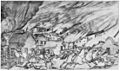
Eyewitness Sherman Enderton's sketch of Quantrill's attack on Lawrence

 In Spanish: Lawrence (Kansas) para niños
