
Wakarusa River facts for kids
Quick facts for kids Wakarusa River |
|
|---|---|

Falls of the Wakarusa River
|
|
| Country | United States |
| State | Kansas |
| Physical characteristics | |
| Main source | Wabaunsee County, Kansas 1,261 ft (384 m) 38°53′44″N 95°57′36″W / 38.89556°N 95.96000°W |
| River mouth | Kansas River Eudora, Kansas 781 ft (238 m) 38°57′22″N 95°04′56″W / 38.95611°N 95.08222°W |
| Length | 80.5 mi (129.6 km) |
| Basin features | |
| River system | Wakarusa—Kansas—Missouri—Mississippi |
The Wakarusa River is a river in eastern Kansas, United States. It flows for about 80.5 mi (129.6 km). The river is a tributary of the Kansas River. This means it flows into the Kansas River.
The Wakarusa River starts in Wabaunsee County, Kansas. It flows east, passing south of the cities of Topeka and Lawrence. The river then joins the Kansas River near Eudora, Kansas. The Wakarusa River is part of a larger river system. Its waters eventually flow into the Missouri River and then the mighty Mississippi River.
Contents
Exploring the Wakarusa River
The Wakarusa River is a great place for outdoor activities. Many people enjoy visiting the areas around the river. It offers chances to connect with nature and learn about the local environment.
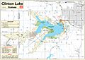
Clinton Lake and State Park
A big part of the Wakarusa River is Clinton Lake. This large lake was created by building a dam on the river. Clinton Lake is a popular spot for fun activities.
What Can You Do at Clinton Lake?
Clinton Lake is part of Clinton State Park. The park offers many ways to enjoy the outdoors. You can go boating, fishing, or swimming in the lake. There are also trails for hiking and biking around the park. It's a perfect place for a family day out.
How Does the Lake Help the River?
The dam that created Clinton Lake helps control the flow of the Wakarusa River. This can prevent floods during heavy rains. It also helps keep a steady water supply for the area.
The Wakarusa River's History
The Wakarusa River has played a role in the history of Kansas. The area around the river was important during a time called "Bleeding Kansas." This was a period of conflict before the American Civil War.
The California Road
A branch of the historic California Trail passed near the Wakarusa River. This path was known as the California Road. It connected Westport Landing (part of today's Kansas City) to Lawrence, Kansas. Many travelers used this road on their way west.
Facts About the Wakarusa River
- The river's source is about 1,261 ft (384 m) above sea level.
- It flows down to about 781 ft (238 m) where it meets the Kansas River.
- The amount of water flowing in the river changes. Sometimes it can be very low, even 0 cu ft/s (0 m3/s).
- Other times, especially after heavy rains, it can flow very fast. It has been recorded flowing as high as 22,600 cu ft/s (640 m3/s).
- On average, about 219 cu ft/s (6.2 m3/s) of water flows through it.
Related Pages
Images for kids
-
USACE area map

