Wabaunsee County, Kansas facts for kids
Quick facts for kids
Wabaunsee County
|
|
|---|---|

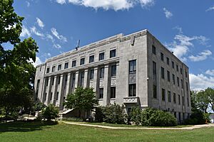
Wabaunsee County Courthouse in Alma (2021)
|
|

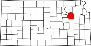
Location within the U.S. state of Kansas
|
|
 Kansas's location within the U.S. |
|
| Country | |
| State | |
| Founded | 1859 |
| Named for | Chief Waubonsie |
| Seat | Alma |
| Largest city | Alma |
| Area | |
| • Total | 800 sq mi (2,000 km2) |
| • Land | 794 sq mi (2,060 km2) |
| • Water | 5.3 sq mi (14 km2) 0.7% |
| Population
(2020)
|
|
| • Total | 6,877 |
| • Estimate
(2021)
|
6,966 |
| • Density | 8.7/sq mi (3.4/km2) |
| Time zone | UTC−6 (Central) |
| • Summer (DST) | UTC−5 (CDT) |
| Congressional district | 2nd |
Wabaunsee County is a county located in the state of Kansas. Its main town, called the county seat, is Alma. In 2020, about 6,877 people lived there. The county got its name from Chief Waubonsie, a leader of the Potawatomi Indians.
Contents
History of Wabaunsee County

For thousands of years, Native Americans lived in the area that is now Kansas. In 1803, the United States bought a huge area of land, including what is now Kansas, as part of the Louisiana Purchase. The first European settlers in the area were said to be a group of outlaws known as the McDaniel Gang.
Early Settlements and Naming
In 1854, the Kansas Territory was created. Wabaunsee County was officially formed by the government on March 25, 1859. The name "Wabaunsee" comes from the Potawatomi language, meaning "dawn of day." It was the name of a respected chief of the Potawatomi Indians.
Before 1859, the county was briefly named "Richardson." This was to honor William Alexander Richardson, a congressman who helped create the Kansas and Nebraska territories.
Important Events in the 1800s
Also in 1854, the Beecher Bible and Rifle Church was started. This church was founded by people who wanted Kansas to be a "free state," meaning they were against slavery. They even had rifles shipped to the church in boxes marked "Bibles" to help with their cause. Captain William Mitchell, Jr., a sailor who joined the Wabaunsee settlement, was very important in helping the county grow. He also helped with the Underground Railroad, a secret network that helped enslaved people escape to freedom.
The first church in the county, Wabaunsee Church of Christ, was founded in June 1857. In 1861, Kansas officially became the 34th U.S. state, joining as a free state.
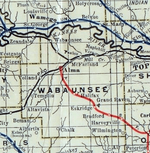
The first railroad, the Atchison, Topeka, and Santa Fe, was built through Wabaunsee County in 1880. Later, in 1887, the Chicago, Kansas and Nebraska Railway built another main line. This helped connect many towns in the county, making travel and trade easier.
Challenges in the 1900s
A huge drought started in 1930, leading to many dust storms that lasted until 1941. This period is known as the Dust Bowl. At the same time, the Great Depression hit, making it hard for people to find jobs and money. Many farmers had to leave their land because of the dry weather and economic problems.
To help people, the government started programs like the Civilian Conservation Corps and the Works Progress Administration. These programs gave jobs to thousands of Kansans, helping them earn money and build important things like roads and bridges.
During World War II, the U.S. Army set up a camp for German prisoners of war near Lake Wabaunsee. These prisoners helped with farm work and building bridges in the area. They were paid for their work and given lunch.
Geography
Wabaunsee County covers about 800 square miles (2,072 square kilometers). Most of this area is land, with a small part being water, like rivers and lakes.
Neighboring Counties
Wabaunsee County shares its borders with several other counties:
- Pottawatomie County (to the north)
- Shawnee County (to the east)
- Osage County (to the southeast)
- Lyon County (to the south)
- Morris County (to the southwest)
- Geary County (to the west)
- Riley County (to the northwest)
Population and People

| Historical population | |||
|---|---|---|---|
| Census | Pop. | %± | |
| 1860 | 1,023 | — | |
| 1870 | 3,362 | 228.6% | |
| 1880 | 8,756 | 160.4% | |
| 1890 | 11,720 | 33.9% | |
| 1900 | 12,813 | 9.3% | |
| 1910 | 12,721 | −0.7% | |
| 1920 | 11,424 | −10.2% | |
| 1930 | 10,830 | −5.2% | |
| 1940 | 9,219 | −14.9% | |
| 1950 | 7,212 | −21.8% | |
| 1960 | 6,648 | −7.8% | |
| 1970 | 6,397 | −3.8% | |
| 1980 | 6,867 | 7.3% | |
| 1990 | 6,603 | −3.8% | |
| 2000 | 6,885 | 4.3% | |
| 2010 | 7,053 | 2.4% | |
| 2020 | 6,877 | −2.5% | |
| 2023 (est.) | 7,057 | 0.1% | |
| U.S. Decennial Census 1790-1960 1900-1990 1990-2000 2010-2020 |
|||
Wabaunsee County is part of the larger Topeka area.
In 2000, there were 6,885 people living in the county. The population was spread out, with about 26.7% of people being under 18 years old. The average age in the county was 40 years.
Education
The county has several school districts that serve its communities:
- Wamego USD 320
- Wabaunsee USD 329
- Mission Valley USD 330
Communities

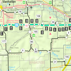
Wabaunsee County has several cities, small communities, and even some "ghost towns" where people used to live but don't anymore.
Cities
- Alma (This is the county seat, where the main government offices are.)
- Alta Vista
- Eskridge
- Harveyville
- Maple Hill
- McFarland
- Paxico
- St. Marys (Part of this city is in another county.)
- Willard (Part of this city is in another county.)
Unincorporated Communities
These are smaller communities that are not officially cities.
Ghost Towns
These are places that used to be towns but are now abandoned.
- Bradford
- Vera
Townships
Wabaunsee County is divided into thirteen smaller areas called townships. These townships help organize the county's land and services. Each city within the county is part of one of these townships.
See also
 In Spanish: Condado de Wabaunsee para niños
 | Mary Eliza Mahoney |
 | Susie King Taylor |
 | Ida Gray |
 | Eliza Ann Grier |


