
Alma, Kansas facts for kids
Quick facts for kids
Alma, Kansas
|
|
|---|---|
|
City and County seat
|
|

Brandt Hotel (2017)
|
|
| Nickname(s):
"City of Native Stone Set in the Flinthills"
|
|

Location within Wabaunsee County and Kansas
|
|

|
|
| Country | United States |
| State | Kansas |
| County | Wabaunsee |
| Founded | 1867 |
| Incorporated | 1869 |
| Government | |
| • Type | Mayor–Council |
| Area | |
| • Total | 0.60 sq mi (1.55 km2) |
| • Land | 0.58 sq mi (1.51 km2) |
| • Water | 0.01 sq mi (0.04 km2) |
| Elevation | 1,096 ft (334 m) |
| Population
(2020)
|
|
| • Total | 802 |
| • Density | 1,337/sq mi (517.4/km2) |
| Time zone | UTC-6 (CST) |
| • Summer (DST) | UTC-5 (CDT) |
| ZIP codes |
66401, 66501
|
| Area code | 785 |
| FIPS code | 20-01350 |
| GNIS ID | 2393926 |
Alma is a city in Kansas, United States. It is the main town, or county seat, of Wabaunsee County. In 2020, about 802 people lived there. Alma is known as the "City of Native Stone Set in the Flinthills."
Contents
History of Alma
Early Beginnings
For thousands of years, Native American tribes lived on the land that is now Kansas. In 1803, the United States bought a huge area of land, including modern Kansas. This was part of the Louisiana Purchase.
Later, in 1854, the Kansas Territory was created. Kansas then became the 34th U.S. state in 1861. Wabaunsee County was formed in 1859. The very first house in Alma was built in 1867.
Railroad History
In 1887, the Chicago, Kansas and Nebraska Railway built a main train line. This line went through Alma, connecting Topeka to Herington. The Chicago, Rock Island and Pacific Railway later took over this line. Today, the Union Pacific Railroad owns and runs it. Many local people still call it the "Rock Island" line.
How Alma Got Its Name
The city of Alma was named in one of two ways. It might have been named after a city called Alma in Germany. Or, it could have been named after a river in Ukraine.
Geography of Alma
Alma is a small city. It covers about 0.59 square miles (1.53 square kilometers). Most of this area is land, about 0.58 square miles (1.51 square kilometers). A very small part, 0.01 square miles (0.04 square kilometers), is water.
Population and People
| Historical population | |||
|---|---|---|---|
| Census | Pop. | %± | |
| 1880 | 362 | — | |
| 1890 | 1,125 | 210.8% | |
| 1900 | 966 | −14.1% | |
| 1910 | 1,010 | 4.6% | |
| 1920 | 789 | −21.9% | |
| 1930 | 811 | 2.8% | |
| 1940 | 776 | −4.3% | |
| 1950 | 716 | −7.7% | |
| 1960 | 838 | 17.0% | |
| 1970 | 905 | 8.0% | |
| 1980 | 925 | 2.2% | |
| 1990 | 871 | −5.8% | |
| 2000 | 797 | −8.5% | |
| 2010 | 832 | 4.4% | |
| 2020 | 802 | −3.6% | |
| U.S. Decennial Census | |||
Alma is part of the larger Topeka area. In 2020, 802 people lived in Alma. There were 324 households, which are groups of people living together. The average household had about 2.4 people.
The median age in Alma was 42.4 years old in 2020. This means half the people were older and half were younger than 42.4. About 24.1% of the population was under 18 years old.
Education in Alma
The public schools in Alma are part of the Wabaunsee USD 329 school district. This district was formed by combining schools from Alma, Maple Hill, McFarland, and Paxico. Wabaunsee High School is located in Alma. The school's mascot is the Wabaunsee Chargers.
Alma High School used to exist but closed when the schools combined. Its mascot was the Blue Devils.
Local Events
Alma hosts a fun event called Hot Alma Nights. This event takes place on the third Saturday in August each year.
Images for kids
-
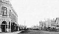
Missouri Street in Alma (1901)
-
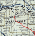
1915 Railroad Map of Wabaunsee County
.jpg)

See also
 In Spanish: Alma (Kansas) para niños
