
Herington, Kansas facts for kids
Quick facts for kids
Herington, Kansas
|
|
|---|---|

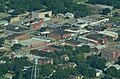
Aerial view of Herington (2013)
|
|

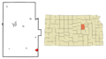
Location within Dickinson County and Kansas
|
|

|
|
| Country | United States |
| State | Kansas |
| Counties | Dickinson, Morris |
| Founded | 1880s |
| Incorporated | 1887 |
| Named for | Monroe Herington |
| Government | |
| • Type | Commissioner-Manager |
| Area | |
| • Total | 4.85 sq mi (12.57 km2) |
| • Land | 4.83 sq mi (12.50 km2) |
| • Water | 0.03 sq mi (0.07 km2) |
| Elevation | 1,463 ft (446 m) |
| Population
(2020)
|
|
| • Total | 2,109 |
| • Density | 434.8/sq mi (167.78/km2) |
| Time zone | UTC-6 (CST) |
| • Summer (DST) | UTC-5 (CDT) |
| ZIP code |
67449
|
| Area code | 785 |
| FIPS code | 20-31400 |
| GNIS ID | 485590 |
Herington is a city in Dickinson and Morris counties in the U.S. state of Kansas. In 2020, about 2,109 people lived there.
Contents
History of Herington
How Herington Started
The city of Herington is named after its founder, Monroe Davis Herington. He was born as Davis Monroe Herrington, but he later decided to drop one "r" from his last name.
The first post office in Herington opened in February 1884. This was an important step for the growing community.
Railroad Days
In 1887, Monroe Herington worked hard to get the Chicago, Kansas and Nebraska Railway to build through the city. He gave land for the railway to create a major hub here. This hub included shops, two roundhouses (where trains were stored and repaired), a freight house, and a telegraph office.
The railway built a main line from Topeka to Herington in 1887. They also extended another main line from Herington to Pratt. This route was known as the "Golden State Limited." In the same year, a branch line was built from Herington south to Caldwell. By 1893, this line reached Fort Worth, Texas, and was called the "OKT."
Over the years, the railway companies changed hands many times. The Chicago, Kansas and Nebraska Railway was later taken over by the Chicago, Rock Island and Pacific Railway. Even today, many local people still call this railway the "Rock Island."
20th Century Changes
In 1912, the National Old Trails Road was created. This important road, also known as the Ocean-to-Ocean Highway, passed right through Herington. Today, the American Discovery Trail, a long trail for hiking and biking, also goes through Herington.
During World War II, a place called Herington Army Airfield was built. It was one of only two airfields that helped prepare large bomber crews and their equipment for overseas missions. After the war, the airfield was given to the city and is now used as the municipal airport.
Geography and Climate
Herington covers about 5.09 square miles (13.18 square kilometers). Most of this area is land, with a small amount of water.
The weather in Herington changes a lot throughout the year. Summers are usually hot, and winters can be cold. The area gets a good amount of rain, especially in the spring and summer months. Snowfall is common in winter but usually not very heavy.
Population Information
| Historical population | |||
|---|---|---|---|
| Census | Pop. | %± | |
| 1890 | 1,353 | — | |
| 1900 | 1,607 | 18.8% | |
| 1910 | 3,273 | 103.7% | |
| 1920 | 4,065 | 24.2% | |
| 1930 | 4,519 | 11.2% | |
| 1940 | 3,804 | −15.8% | |
| 1950 | 3,775 | −0.8% | |
| 1960 | 3,702 | −1.9% | |
| 1970 | 3,165 | −14.5% | |
| 1980 | 2,930 | −7.4% | |
| 1990 | 2,685 | −8.4% | |
| 2000 | 2,563 | −4.5% | |
| 2010 | 2,526 | −1.4% | |
| 2020 | 2,109 | −16.5% | |
| U.S. Decennial Census | |||
2020 Census Details
In 2020, Herington had 2,109 residents. There were 948 households and 515 families living in the city. Most of the people (about 89%) were white. Other groups included African American, Native American, and Asian residents. About 5.5% of the population was Hispanic or Latino.
About 22% of the population was under 18 years old. The median age in the city was 43.3 years. This means half the people were younger than 43.3 and half were older.
2010 Census Details
In 2010, Herington had 2,526 people. There were 1,082 households. About 93% of the people were white. Other groups included African American, Native American, and Asian residents. About 5.7% of the population was Hispanic or Latino.
About 25% of the residents were under 18 years old. The median age was 39.2 years.
Fun Places to Visit
If you visit Herington, here are some interesting places:
- Herington Historical Museum: Learn about the city's past.
- The Kansas Historical Marker of Dwight David Eisenhower: This marker is about 1 mile (1.6 km) south of Herington. It honors Dwight D. Eisenhower, who was a famous general and later a U.S. President.
Education in Herington
_front_view.jpg)
Herington has its own public school district, called Herington USD 487. The high school is part of a special network called T.E.E.N. This network uses video to connect five area high schools for shared classes.
The schools in Herington are:
- Herington High School
- Herington Middle School
- Herington Elementary School
- Herington Little Railer Preschool
Herington Public Library
The Herington Public Library is a Carnegie library. This means it was built with money donated by Andrew Carnegie, a famous businessman who helped build many libraries.
Transportation
Railways
Herington has always been an important place for trains. It was once a major hub for the Rock Island and other railway companies. Today, the Union Pacific Railroad still uses Herington as a key hub in its system.
Airports
For air travel, Herington has:
- Herington Regional Airport, known as FAA:HRU.
- ICAO:KHRU, which is located east of the city.
Famous People from Herington
- Bruce P. Blake: A Bishop in the United Methodist Church.
- Brad Crandall: A well-known radio personality.
- Louis Durant (1910–1972): A race car driver.
- John H. Eastwood (1911–2007): A World War II United States Army chaplain.
- Nathan Johnson (1926–2021): An African American architect known for his modern designs.
- Emil Kapaun (1916–1951): A Roman Catholic priest and United States Army chaplain who received the Medal of Honor.
- Alan Shields (1944–2005): An American visual artist and painter.
- Calvin Wright: A politician from Idaho.
Images for kids
-
Aerial view of Herington (2013)
-
Location within Dickinson County and Kansas
-
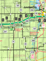
KDOT map of Dickinson County (legend)
See also
 In Spanish: Herington para niños
