Pratt, Kansas facts for kids
Quick facts for kids
Pratt, Kansas
|
|
|---|---|
|
City and county seat
|
|
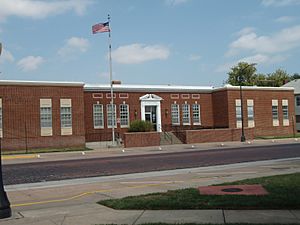
U.S. Post Office (2009)
|
|
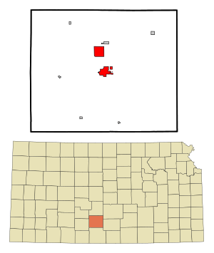
Location within Pratt County and Kansas
|
|
|
|
| Country | United States |
| State | Kansas |
| County | Pratt |
| Founded | 1884 |
| Incorporated | 1884 |
| Named for | Caleb Pratt |
| Area | |
| • Total | 7.83 sq mi (20.29 km2) |
| • Land | 7.71 sq mi (19.97 km2) |
| • Water | 0.12 sq mi (0.32 km2) |
| Elevation | 1,952 ft (595 m) |
| Population
(2020)
|
|
| • Total | 6,603 |
| • Density | 843.3/sq mi (325.43/km2) |
| Time zone | UTC-6 (CST) |
| • Summer (DST) | UTC-5 (CDT) |
| ZIP code |
67124
|
| Area code | 620 |
| FIPS code | 20-57625 |
| GNIS ID | 485645 |
Pratt is a city in Kansas, United States. It is the main city and center of government for Pratt County. In 2020, about 6,603 people lived there. Pratt is also home to Pratt Community College.
Contents
History
How Pratt Started
Pratt was founded in 1884. It was named after Caleb S. Pratt, a young officer from the Civil War. He was part of the Kansas Infantry and died in a battle near Springfield, Missouri. The first post office in Pratt opened in June 1884.
Railroad Days
In 1887, a railroad called the Chicago, Kansas and Nebraska Railway built a main line to Pratt. The next year, this line was extended further. It later reached places like Tucumcari, New Mexico and El Paso, Texas. This railroad was later taken over by the Chicago, Rock Island and Pacific Railway. Even today, many local people still call it the "Rock Island" railroad.
20th Century Developments
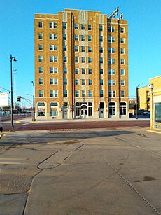
The Hotel Roberts was built in 1930. It was the biggest and most stylish hotel in Pratt at the time. The city's Chamber of Commerce helped make sure the hotel was built. They saw it as a great way to help the community grow. The hotel was even partly paid for by people in the town.
The hotel was designed by Samuel S. Voigt and built by Webster L. Elson. It was known for being "fire-proof." For many years, a community hospital was located on the eighth floor of the building. The hotel is also important because it shows an early example of the Art Deco style in central Kansas. It was added to the National and State Registers of Historic Places in 2015.
During World War II, a place nearby called Pratt Army Airfield was very important. It was the first base where crews learned to fly the Boeing B-29 Superfortress bomber planes. It also helped get early aircraft ready for combat. This was part of what was known as the Battle of Kansas.
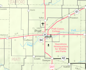
Today, Pratt is also known for hosting the Miss Kansas Parade and Pageant. The main office for the Kansas Department of Wildlife and Parks is located southeast of the city.
Geography
Pratt covers an area of about 7.49 square miles (19.4 square kilometers). Most of this area is land, with a small part being water. The city is located about eighty miles (129 kilometers) west of Wichita.
Climate
Pratt has a humid subtropical climate. This means it has hot, humid summers and mild winters. The hottest temperature ever recorded in Pratt was 115°F (46°C). This happened on June 25, 1911, and also on July 18, 1936, and August 12–13, 1936. The coldest temperature recorded was -25°F (-32°C) on February 12, 1899.
| Climate data for Pratt, Kansas, 1991–2020 normals, extremes 1895–present | |||||||||||||
|---|---|---|---|---|---|---|---|---|---|---|---|---|---|
| Month | Jan | Feb | Mar | Apr | May | Jun | Jul | Aug | Sep | Oct | Nov | Dec | Year |
| Record high °F (°C) | 80 (27) |
89 (32) |
98 (37) |
106 (41) |
107 (42) |
115 (46) |
115 (46) |
115 (46) |
111 (44) |
98 (37) |
89 (32) |
85 (29) |
115 (46) |
| Mean maximum °F (°C) | 68.4 (20.2) |
73.3 (22.9) |
82.3 (27.9) |
89.1 (31.7) |
94.0 (34.4) |
98.8 (37.1) |
104.1 (40.1) |
102.1 (38.9) |
98.0 (36.7) |
89.5 (31.9) |
77.5 (25.3) |
66.7 (19.3) |
106.1 (41.2) |
| Mean daily maximum °F (°C) | 43.1 (6.2) |
47.7 (8.7) |
57.5 (14.2) |
66.7 (19.3) |
76.5 (24.7) |
86.7 (30.4) |
91.5 (33.1) |
89.7 (32.1) |
81.9 (27.7) |
69.8 (21.0) |
55.9 (13.3) |
44.6 (7.0) |
67.6 (19.8) |
| Daily mean °F (°C) | 31.1 (−0.5) |
35.0 (1.7) |
44.3 (6.8) |
53.6 (12.0) |
64.3 (17.9) |
74.6 (23.7) |
79.2 (26.2) |
77.5 (25.3) |
69.3 (20.7) |
56.6 (13.7) |
43.4 (6.3) |
33.1 (0.6) |
55.2 (12.9) |
| Mean daily minimum °F (°C) | 19.1 (−7.2) |
22.4 (−5.3) |
31.1 (−0.5) |
40.5 (4.7) |
52.2 (11.2) |
62.5 (16.9) |
66.9 (19.4) |
65.3 (18.5) |
56.7 (13.7) |
43.4 (6.3) |
30.8 (−0.7) |
21.6 (−5.8) |
42.7 (5.9) |
| Mean minimum °F (°C) | 3.6 (−15.8) |
5.7 (−14.6) |
13.1 (−10.5) |
25.6 (−3.6) |
36.1 (2.3) |
50.0 (10.0) |
56.6 (13.7) |
55.2 (12.9) |
41.0 (5.0) |
27.1 (−2.7) |
15.5 (−9.2) |
5.6 (−14.7) |
−1.6 (−18.7) |
| Record low °F (°C) | −16 (−27) |
−25 (−32) |
−12 (−24) |
12 (−11) |
20 (−7) |
38 (3) |
45 (7) |
42 (6) |
26 (−3) |
12 (−11) |
−2 (−19) |
−20 (−29) |
−25 (−32) |
| Average precipitation inches (mm) | 0.64 (16) |
0.99 (25) |
1.97 (50) |
2.67 (68) |
3.80 (97) |
4.10 (104) |
3.25 (83) |
3.36 (85) |
2.32 (59) |
2.23 (57) |
1.18 (30) |
1.11 (28) |
27.62 (702) |
| Average snowfall inches (cm) | 3.6 (9.1) |
3.9 (9.9) |
4.1 (10) |
0.4 (1.0) |
0.0 (0.0) |
0.0 (0.0) |
0.0 (0.0) |
0.0 (0.0) |
0.0 (0.0) |
0.1 (0.25) |
0.4 (1.0) |
2.6 (6.6) |
15.1 (37.85) |
| Average precipitation days (≥ 0.01 in) | 2.3 | 3.2 | 4.1 | 6.0 | 7.3 | 7.2 | 5.8 | 6.1 | 4.5 | 4.6 | 3.2 | 2.9 | 57.2 |
| Average snowy days (≥ 0.1 in) | 1.5 | 1.5 | 0.8 | 0.1 | 0.0 | 0.0 | 0.0 | 0.0 | 0.0 | 0.1 | 0.3 | 1.0 | 5.3 |
| Source 1: NOAA | |||||||||||||
| Source 2: National Weather Service | |||||||||||||
People of Pratt
| Historical population | |||
|---|---|---|---|
| Census | Pop. | %± | |
| 1890 | 1,418 | — | |
| 1900 | 1,213 | −14.5% | |
| 1910 | 3,302 | 172.2% | |
| 1920 | 5,183 | 57.0% | |
| 1930 | 6,322 | 22.0% | |
| 1940 | 6,591 | 4.3% | |
| 1950 | 7,523 | 14.1% | |
| 1960 | 8,156 | 8.4% | |
| 1970 | 6,736 | −17.4% | |
| 1980 | 6,885 | 2.2% | |
| 1990 | 6,687 | −2.9% | |
| 2000 | 6,570 | −1.7% | |
| 2010 | 6,835 | 4.0% | |
| 2020 | 6,603 | −3.4% | |
| U.S. Decennial Census 2010-2020 |
|||
2020 Population Count
In 2020, the census counted 6,603 people living in Pratt. There were 2,646 households, which are groups of people living together. Most people in Pratt were white (about 86%). There were also people who identified as black, Native American, Asian, and people from other races or two or more races. About 9.57% of the population was Hispanic or Latino.
About 23.7% of the people were under 18 years old. The average age in Pratt was 37.7 years.
2010 Population Count
In 2010, there were 6,835 people living in Pratt. The city had 2,837 households. The racial makeup was mostly White (93.3%). Other groups included African American, Native American, and Asian people. About 6.2% of the population was Hispanic or Latino.
About 22.4% of the people were under 18 years old. The average age in the city was 39 years.
Education
Colleges
- Pratt Community College
Public Schools
The public schools in Pratt are managed by two districts: Pratt USD 382 and Skyline USD 438.
- Pratt USD 382
- Pratt High School (grades 9-12)
- Liberty Middle School (grades 5-8)
- Southwest Elementary School (PreK-4)
- Haskins Elementary School & Bridges to Learning (K-4)
- Skyline USD 438 (located west of Pratt)
- Skyline High School (K-12)
Private Schools
- Sacred Heart/Holy Child (PreK-5)
- Our Savior Lutheran Preschool
Media
Radio Stations
- KHMY 93.1FM—Plays popular adult contemporary music.
- KMMM 1290AM — Offers news, sports, information, and music.
- KQZQ 98.3FM - Plays country music.
Newspaper
- Tri County Tribune
Transportation
Pratt is connected by several major roads. These include U.S. Route 54, U.S. Route 400, and U.S. Route 281. It is also served by K-61.
Bus service is available daily. You can travel eastward to Wichita or westward to Pueblo, Colorado using BeeLine Express buses.
Notable People
- Bill Farmer – A voice actor and comedian.
- William Marriott – A baseball player.
- Vera Miles – An actress.
- John Redwine – A doctor and politician.
- Pearl Farmer Richardson – A clubwoman who promoted the United Nations.
- Charles Stokes – A politician.
- Brad Ziegler – A relief pitcher for Major League Baseball.
See also
 In Spanish: Pratt (Kansas) para niños
 | Ernest Everett Just |
 | Mary Jackson |
 | Emmett Chappelle |
 | Marie Maynard Daly |


