
U.S. Route 54 facts for kids
Quick facts for kids
|
|
|---|---|
 |
|
| Route information | |
| Length | 1,197 mi (1,926 km) |
| Existed | 1926–present |
| Major junctions | |
| West end | |
|
|
| East end | |
| Location | |
| States: | Texas, New Mexico, Oklahoma, Kansas, Missouri, Illinois |
| Highway system | |
| United States Numbered Highways List • Bannered • Divided • Replaced |
|

U.S. Route 54 (US 54) is a very long road that goes across the United States. It runs for about 1,197 miles (1,926 kilometers). This highway connects Griggsville, Illinois, in the east to El Paso, Texas, in the west. It is an important route for travel and transportation across several states.
The eastern end of US 54 is in Griggsville, Illinois. Here, it meets Interstate 72. The western end is in El Paso, Texas, very close to the border with Mexico.
Contents
About the Route
US 54 travels in a northeast-southwest direction. It passes through six different states. These states are Texas, New Mexico, Oklahoma, Kansas, Missouri, and Illinois.
Journey Through States
The highway actually enters and leaves Texas twice. First, it starts in El Paso, Texas. Then, it goes into New Mexico. After that, it re-enters Texas in the Panhandle region before moving into Oklahoma.
Railroad Connections
A big part of US 54 runs right next to a railroad line. This is the Union Pacific Railroad's Tucumcari Line. This railroad used to be called the "Golden State Route." It follows US 54 from El Paso all the way to Pratt, Kansas. This means the road and the train tracks travel side-by-side for about two-thirds of the highway's total length.
Length in Each State
US 54 covers different distances in each state it crosses. Here is a quick look at how many miles it travels in each area:
- Texas (El Paso area): About 20 miles (32 km)
- New Mexico: About 355 miles (571 km)
- Texas (Panhandle area): About 92 miles (148 km)
- Oklahoma: About 56 miles (90 km)
- Kansas: About 380 miles (612 km)
- Missouri: About 279 miles (449 km)
- Illinois: About 24 miles (38 km)
In total, US 54 is about 1,206 miles (1,940 km) long when you add up all these sections.
Images for kids
-
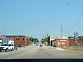
US 54 meets US 69 and K-7 in Fort Scott, Kansas.
-
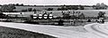
This photo shows an old junction in Pittsfield, Illinois, from 1926.
-
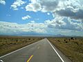
US Route 54 traveling through the beautiful landscape of New Mexico.
-
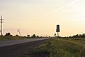
US 54 and US 400 together, west of Pratt, Kansas.
-

The Jefferson City Bridge, which is part of US 54.


