
Interstate 40 facts for kids
Quick facts for kids
|
|
|---|---|
| Lua error in Module:Infobox_road/map at line 15: attempt to index field 'wikibase' (a nil value). | |
| Route information | |
| Length | 2,555.10 mi (4,112.03 km) |
| Major junctions | |
| West end | |
| East end | |
| Highway system | |
| Main route of the Interstate Highway System Main • Auxiliary • Business |
|

Interstate 40, or I-40, is a major Interstate Highway in the United States. It stretches all the way from Barstow, California in the west to Wilmington, North Carolina in the east. This long road is about 2,555.10 miles (4,112.03 km) long.
I-40 crosses through eight different states. From west to east, these states are California, Arizona, New Mexico, Texas, Oklahoma, Arkansas, Tennessee, and North Carolina. It also passes through many important cities along the way.
Cities Along I-40
Interstate 40 connects many big cities across the country. As you travel from west to east, some of the major cities you would see include:
- Albuquerque, New Mexico
- Oklahoma City, Oklahoma
- Little Rock, Arkansas
- Memphis, Tennessee
- Nashville, Tennessee
- Winston-Salem, North Carolina
- Greensboro, North Carolina
- Durham, North Carolina
- Raleigh, North Carolina
These cities are important centers for business, culture, and travel. I-40 helps people and goods move easily between them.
History and Importance
Interstate 40 is a very important part of the American road network. It helps connect the western and eastern parts of the country. This highway is used by millions of cars and trucks every year. It plays a big role in trade and tourism.
Before I-40 was built, many people used U.S. Route 66. Parts of I-40 were built along the same path as the old Route 66. This means I-40 carries on the tradition of being a major cross-country road.
Interesting Facts
- I-40 is one of the longest Interstate Highways in the United States.
- It crosses the Mississippi River on the Hernando de Soto Bridge in Memphis, Tennessee. This bridge is a famous landmark.
- In 2002, a section of the I-40 bridge over the Arkansas River collapsed. This was a serious event that led to repairs and safety checks.
Images for kids
-
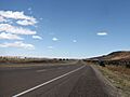
I-40 in eastern New Mexico, showing the wide-open spaces it crosses.
-
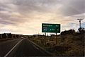
A sign at the start of I-40 in Barstow, California, showing the distance to the freeway's eastern terminus in Wilmington, North Carolina. This sign has been stolen several times.
-

I-40 westbound heading toward Flagstaff
-
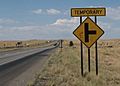
An at-grade intersection on I-40 in Texas in 2003
-

The Hernando de Soto Bridge, where I-40 crosses the Mississippi River into Memphis
-

I-40 in Nashville
-
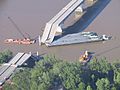
The collapsed section of the I-40 bridge, May 31, 2002


See also
 In Spanish: Interestatal 40 para niños
