Kingdom City, Missouri facts for kids
Quick facts for kids
Kingdom City, Missouri
|
|
|---|---|
|
Village
|
|
| Village of Kingdom City | |

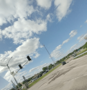
Kingdom City in May 2024
|
|

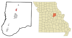
Location of Kingdom City, Missouri
|
|
| Country | United States |
| State | Missouri |
| County | Callaway |
| Incorporated | 1973 |
| Area | |
| • Total | 1.88 sq mi (4.85 km2) |
| • Land | 1.85 sq mi (4.80 km2) |
| • Water | 0.02 sq mi (0.05 km2) |
| Elevation | 801 ft (244 m) |
| Population
(2020)
|
|
| • Total | 134 |
| • Density | 72.28/sq mi (27.91/km2) |
| Time zone | UTC-6 (Central (CST)) |
| • Summer (DST) | UTC-5 (CDT) |
| ZIP code |
65262
|
| Area code(s) | 573 |
| FIPS code | 29-38792 |
| GNIS feature ID | 2398350 |
| U.S. Routes | |
| Interstates | |
Kingdom City is a small village in Callaway County, Missouri, in the United States. It is part of the larger Jefferson City area. In 2020, about 134 people lived here. This village is special because it sits right where two important highways, Interstate 70 and U.S. Route 54, meet.
Contents
The Story of Kingdom City
How the Highways Shaped the Town
Kingdom City began to grow in 1925. This was when U.S. Route 40 was being built. At the same time, U.S. Route 54 was planned to cross it. The city of Fulton wanted Route 40 to go through their city. They hoped it would meet Route 54 there.
But the final decision was different. The highways would meet in what became Kingdom City. This area was just farms and forests back then. It was south of a place called McCredie. People from McCredie really wanted the highway. They even had a parade in Fulton to show their support.
When the road was being built, many workers came to the area. McCredie became a "boom town." This means it grew very quickly. Kingdom City got its first gas station and a hotel. Sadly, the hotel burned down in 1930.
Naming the Village
At first, the area where the highways met had no name. People just called it "the Y." Folks in Fulton wanted to call it "North Fulton." People in McCredie preferred "South McCredie."
Then, the Kingdom Oil Company suggested a name. Its owner, B.P. Beamer, thought of "Kingdom City." This name honored Callaway County's nickname, "The Kingdom."
Growing Over Time
Through the 1920s and 1930s, many businesses opened and closed. These included dance halls, restaurants, and cafes. A local favorite called Gasper's opened in 1965.
In 1970, the McCredie Post Office moved to Kingdom City. It then took on the community's name. This was also the year Kingdom City officially became a village. It even included the former area of McCredie.
A historic building, the Richland Christian Church, is in Kingdom City. It was added to the National Register of Historic Places in 2001.
Where is Kingdom City?
Location and Nearby Features
Kingdom City is located along U.S. Route 54. It is about half a mile north of I-70. McKinney Creek flows along the south side of the village. Auxvasse Creek is about two miles north. The town of Auxvasse is about five miles north on Route 54.
Future Road Improvements
The intersection of the highways in Kingdom City is very important. It is planned to be updated soon. The current intersection will be changed into a roundabout. This change is part of a bigger project. It aims to improve I-70 across all of Missouri. Construction is planned to start in 2024.
How Many People Live Here?
Kingdom City is a small community. The number of people living there has changed over the years.
- 1970: 53 people
- 1980: 146 people
- 1990: 112 people
- 2000: 121 people
- 2010: 128 people
- 2020: 134 people
See also
 In Spanish: Kingdom City (Misuri) para niños
 | Misty Copeland |
 | Raven Wilkinson |
 | Debra Austin |
 | Aesha Ash |


