Auxvasse, Missouri facts for kids
Quick facts for kids
Auxvasse, Missouri
|
|
|---|---|
| City of Auxvasse | |

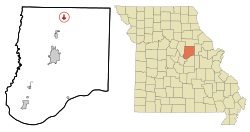
Location of Auxvasse, Missouri
|
|
| Country | United States |
| State | Missouri |
| County | Callaway |
| Founded | 1873 (as Clinton City) |
| Incorporated | 1874 |
| Named for | The Auxvasse Creek |
| Area | |
| • Total | 0.76 sq mi (1.96 km2) |
| • Land | 0.76 sq mi (1.96 km2) |
| • Water | 0.00 sq mi (0.00 km2) |
| Elevation | 866 ft (264 m) |
| Population
(2020)
|
|
| • Total | 1,001 |
| • Density | 1,325.83/sq mi (511.89/km2) |
| Time zone | UTC-6 (Central (CST)) |
| • Summer (DST) | UTC-5 (CDT) |
| ZIP code |
65231
|
| Area code(s) | 573 |
| FIPS code | 29-02638 |
| GNIS feature ID | 2394038 |
| U.S. Routes | |
Auxvasse (pronounced "uv-AWZ") is a city in northern Callaway County, Missouri, United States. It is part of the Jefferson City Metropolitan Area. In 2020, the city had a population of 1,001 people.
Contents
History of Auxvasse
Auxvasse was first known as Clinton City. It was officially planned out, or "plat"ted, in 1873. The city was named after the nearby Auxvasse Creek. A post office opened in Auxvasse in 1874.
Over the years, the city's location within different townships in Callaway County changed. Townships are like smaller areas within a county. Auxvasse was first part of the Cote Sans Dessein township. Later, it became part of Liberty Township for almost 40 years. Since December 1875, Auxvasse has been located in Jackson Township. It is now the largest town in that township.
Geography of Auxvasse
Auxvasse is located in the northern part of Callaway County. You can find it along U.S. Route 54. This highway connects Auxvasse to Mexico to the north and Kingdom City to the south.
The United States Census Bureau says that Auxvasse covers a total area of 0.76 square miles (1.96 square kilometers). All of this area is land, with no water.
Population of Auxvasse
| Historical population | |||
|---|---|---|---|
| Census | Pop. | %± | |
| 1890 | 348 | — | |
| 1900 | 337 | −3.2% | |
| 1910 | 411 | 22.0% | |
| 1920 | 484 | 17.8% | |
| 1930 | 438 | −9.5% | |
| 1940 | 490 | 11.9% | |
| 1950 | 507 | 3.5% | |
| 1960 | 534 | 5.3% | |
| 1970 | 808 | 51.3% | |
| 1980 | 858 | 6.2% | |
| 1990 | 821 | −4.3% | |
| 2000 | 901 | 9.7% | |
| 2010 | 983 | 9.1% | |
| 2020 | 1,001 | 1.8% | |
| U.S. Decennial Census | |||
2010 Census Information
According to the census from 2010, there were 983 people living in Auxvasse. These people lived in 405 households, and 261 of these were families. The city had about 1,293 people per square mile (500 people per square kilometer). There were 472 housing units, which are places where people live.
Most of the people in Auxvasse were White (94.1%). There were also African American (3.2%), Native American (1.3%), and Asian (0.5%) residents. A small number of people were from other races or from two or more races. About 1.1% of the population was Hispanic or Latino.
Out of the 405 households:
- 37.5% had children under 18 living with them.
- 45.9% were married couples.
- 12.6% had a female head of the household with no husband present.
- 5.9% had a male head of the household with no wife present.
- 35.6% were not families.
About 29.9% of all households had only one person living there. Also, 12.6% of households had someone aged 65 or older living alone. The average household had 2.43 people, and the average family had 3.03 people.
The average age of people in the city was 36.5 years.
- 28.4% of residents were under 18.
- 8.7% were between 18 and 24.
- 24.9% were between 25 and 44.
- 24.8% were between 45 and 64.
- 13.2% were 65 years or older.
The population was 47.4% male and 52.6% female.
See also
 In Spanish: Auxvasse (Misuri) para niños
 | DeHart Hubbard |
 | Wilma Rudolph |
 | Jesse Owens |
 | Jackie Joyner-Kersee |
 | Major Taylor |

