
Interstate 10 facts for kids
Quick facts for kids
|
|
|---|---|
|
I-10 highlighted in red
|
|
| Route information | |
| Length | 2,460.34 mi (3,959.53 km) |
| Existed | 1957–present |
| Major junctions | |
| West end | |
|
|
| East end | |
| Location | |
| States: | California, Arizona, New Mexico, Texas, Louisiana, Mississippi, Alabama, Florida |
| Highway system | |
| Main route of the Interstate Highway System Main • Auxiliary • Business |
|

Interstate 10 (or I-10) is a very long Interstate Highway in the United States. It starts on the west side in Santa Monica, California, which is close to Los Angeles. Its eastern end is in Jacksonville, Florida. This highway connects the Pacific Ocean to the Atlantic Ocean!
I-10 was created in 1957. It is about 2,460.34 miles (3,959.53 km) long. The highway travels through eight different states. In Texas, some parts of I-10 have a speed limit of 80 mi (128.7 km) per hour. This makes it one of the fastest routes in the state.
Cities Along the I-10 Highway
Interstate 10 passes through many important cities as it crosses the country. These cities are major stops for travelers and businesses. Here are some of the big cities you would find along I-10:
- Los Angeles, California
- San Bernardino, California
- Palm Springs, California
- Phoenix, Arizona
- Tucson, Arizona
- Las Cruces, New Mexico
- El Paso, Texas
- San Antonio, Texas
- Houston, Texas
- Lake Charles, Louisiana
- Lafayette, Louisiana
- Baton Rouge, Louisiana
- New Orleans, Louisiana
- Biloxi, Mississippi
- Mobile, Alabama
- Pensacola, Florida
- Tallahassee, Florida
- Jacksonville, Florida
Images for kids
-
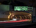
Western end of I-10 at the McClure Tunnel in Santa Monica
-
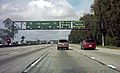
The San Bernardino Freeway in California near the interchange with the Ontario Freeway (I-15)
-
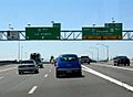
The end of I-17 at I-10 in Phoenix
-
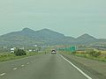
View of Lordsburg from US 70 and the junction with I-10 in New Mexico
-
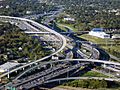
I-45 and I-10 next to Downtown Houston
-
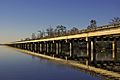
I-10 running west of New Orleans, spans the Bonnet Carré Spillway at Lake Pontchartrain
-
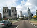
I-10 eastbound in downtown Mobile approaching the George Wallace Tunnel
-
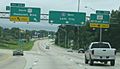
I-10 west at the interchange for US 17 Alt south in Jacksonville
-
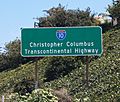
This sign in Santa Monica, California, declares that I-10 is the "Christopher Columbus Transcontinental Highway"


See also
 In Spanish: Interestatal 10 para niños
