Bonnet Carré Spillway facts for kids
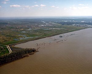
The Bonnet Carré Spillway is a special structure built to control floods in the lower Mississippi River area. It's located in St. Charles Parish, Louisiana, about 12 miles (19 km) west of New Orleans. This spillway helps move extra floodwaters from the Mississippi River into Lake Pontchartrain, and then into the Gulf of Mexico. It was built between 1929 and 1931 after a very big flood in 1927. The American Society of Civil Engineers has called it a National Historic Civil Engineering Landmark.
Contents
What is the Bonnet Carré Spillway?
The Bonnet Carré Spillway has two main parts. One is a control structure along the east bank of the Mississippi River. The other is a floodway that carries the diverted water to Lake Pontchartrain.
How the Spillway Works
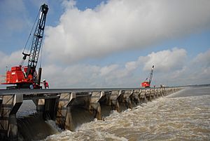
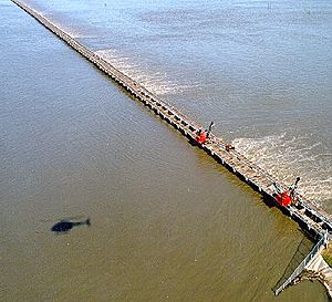
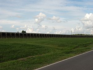
The control structure is a concrete wall that is over a mile and a half long. It has special gates that can be opened. When these gates are opened, extra water from the river flows into Lake Pontchartrain. The lake is big enough to handle a lot of water. This helps lower the river level near New Orleans. It also reduces the stress on the levees, which are walls built to hold back the river.
The floodway is like a wide channel. It stretches almost six miles (10 km) to Lake Pontchartrain. It can handle a lot of water, about 250,000 cubic feet per second. Major roads like U.S. Route 61 and Interstate 10 cross over the spillway.
Why Was It Built?
The spillway was built because of the Great Mississippi Flood of 1927. This flood covered a huge part of the Mississippi River basin. The spillway was first used during the flood of 1937. Since then, it has been opened many times to help control river levels near New Orleans. For example, it was opened twice in 2019, which was the first time that happened in one year.
How the Spillway Opens
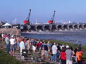
The spillway opens by lifting out many wooden beams called 'needles'. There are about 7,000 of these needles. They are arranged in 350 sections, or 'bays'. Two cranes on rails lift these needles. The more needles that are removed, the more water flows into the spillway. It takes about 36 hours to remove all 7,000 needles. This is usually done over several days.
Part of a Bigger Plan
The Bonnet Carré Spillway is part of a much larger plan. This plan is called the Mississippi River and Tributaries Project (MR&T). The United States Army Corps of Engineers manages it. This project protects the entire alluvial valley of the Mississippi River. It stretches from Missouri all the way to the mouth of the river in Louisiana.
The MR&T Project uses many different features to control floods. These include:
- levees to hold back floodwaters.
- Floodways like the Bonnet Carré Spillway to move extra water away from the river.
- Improvements to the river channel and river banks for better navigation.
- Reservoirs and pumping stations to help with flood control drainage.
History of Openings
The table below shows when the Bonnet Carré Spillway has been opened. It also shows how long it stayed open and how much of its capacity was used. The spillway can handle 250,000 cubic feet per second when all 350 bays are open. Each bay can handle about 714.3 cubic feet per second.
| Year | Date Opened | Days Open | Bays Opened | (%) Opened | Ideal flow capacity |
|---|---|---|---|---|---|
| 1937 | January 28 | 48 | 285 | 81.4% | 203,571 cu ft/s |
| 1945 | March 23 | 57 | 350 | 100% | 250,000 cu ft/s |
| 1950 | February 10 | 38 | 350 | 100% | 250,000 cu ft/s |
| 1973 | April 8 | 75 | 350 | 100% | 250,000 cu ft/s |
| 1975 | April 14 | 13 | 225 | 64.3% | 160,714 cu ft/s |
| 1979 | April 17 | 45 | 350 | 100% | 250,000 cu ft/s |
| 1983 | May 20 | 35 | 350 | 100% | 250,000 cu ft/s |
| 1997 | March 17 | 31 | 298 | 85.1% | 212,857 cu ft/s |
| 2008 | April 11 | 31 | 160 | 45.7% | 114,286 cu ft/s |
| 2011 | May 9 | 42 | 330 | 94.3% | 235,714 cu ft/s |
| 2016 | January 10 | 22 | 210 | 60.0% | 203,000 cu ft/s |
| 2018 | March 8 | 22 | 168 | 48.0% | 196,000 cu ft/s |
| 2019 | February 27 | 43 | 206 | 58.9% | 213,000 cu ft/s |
| 2019 | May 10 | 79 | 168 | 48.0% | 161,000 cu ft/s |
| 2020 | April 3 | 28 | 90 | 25.71% | 90,000 cu ft/s |
Cemeteries in the Spillway
There are two old cemeteries located inside the spillway area. These cemeteries hold the remains of enslaved people and free African-Americans. When the spillway gates are opened, these cemeteries get flooded.
For a long time, no one knew exactly where these graves were. In 1975, a tombstone and casket were found during digging work. Later, in 1986, a study found a second cemetery. Both cemeteries were added to the National Register of Historic Places in 1987. Things found there included parts of coffins, grave markers, and human remains.
These cemeteries, called Kenner Cemetery and Kugler Cemetery, were used from the early 1800s until 1929. Some African-American Civil War veterans buried there were moved in 1930. The exact number of burials is not known. These sites were next to sugar plantations in St. Charles Parish. Today, young live oak trees mark the cemetery sites.
Using the Spillway Land
The spillway area is very large, about 7,600 acres (30.7 km²). It's a major source of sand and clay. This sand and clay is used for construction projects in the area. After Hurricane Katrina, clay from the spillway became very important for making the levees higher in St. Charles Parish and east Jefferson Parish.
The spillway also serves as a fun place for recreation. People use it for off-road vehicles, biking, hiking, hunting, and fishing. The Louisiana Department of Wildlife and Fisheries has made it a protected wildlife management area. To make fishing better, the clay pits were filled with water and stocked with fish like bluegill and largemouth bass.
New Diversion Projects
Other projects have shown that diverting fresh water can help keep wetlands healthy. This has led to ideas for more fresh water diversion projects. One idea is a "Bonnet Carré Spillway diversion." This would be built within the spillway itself. It would allow fresh water and sediment to flow into Lake Pontchartrain and the Mississippi Sound.
This new diversion could help slow down land sinking, which would save about 10,500 acres of marshland over 50 years. It would also protect fish and wildlife and help with storm surge protection. This project was approved by Congress in 1988. The cost would be shared, with the federal government paying 75%, Louisiana 20%, and Mississippi 5%. However, Louisiana withdrew its support in 1996, so an agreement has not yet been reached.
 | Frances Mary Albrier |
 | Whitney Young |
 | Muhammad Ali |


