
Lake Pontchartrain facts for kids
Quick facts for kids Lake Pontchartrain |
|
|---|---|

Landsat image
|
|

Map
|
|
| Coordinates | |
| Type | salt-water lake |
| Basin countries | United States |
| Surface area | 630 sq mi (1630 km²) |
| Settlements | New Orleans, Metairie, Kenner, Mandeville, Slidell, Madisonville, etc. |
Lake Pontchartrain is a large, unique lake in southeastern Louisiana, USA. It's often called a lake, but it's actually an estuary. This means it's a place where fresh water from rivers mixes with salt water from the ocean.
It is the second largest salt-water lake in the United States, right after the Great Salt Lake in Utah. It's also the biggest lake in all of Louisiana.
Contents
Discovering Lake Pontchartrain
Lake Pontchartrain covers a huge area of about 630 square miles (1630 square kilometers). Imagine a lake that's roughly 40 miles (64 km) wide and 24 miles (39 km) from north to south!
How Deep is Lake Pontchartrain?
The lake is not very deep on average. Most of it is about 12 to 14 feet (around 4 meters) deep. However, some parts are made deeper for ships to pass through. This is done by a process called dredging, which means digging up the bottom of the lake.
What is Brackish Water?
Lake Pontchartrain has brackish water. This means its water is a mix of fresh water and salt water. Rivers like the Tangipahoa River and the Tchefuncte River flow into the lake, bringing fresh water. At the same time, the lake connects to the Gulf of Mexico through smaller waterways, allowing salt water to enter. This mix creates a special environment for many different plants and animals.
Lake Pontchartrain and Weather Events
Because of its location near the Gulf of Mexico, Lake Pontchartrain can be affected by strong storms, especially hurricanes.
Lake Pontchartrain During Hurricanes
When hurricanes hit the coast, Lake Pontchartrain can experience very high winds and storm surges. A storm surge is when the ocean water is pushed onto land by the strong winds of a storm.
For example, during Hurricane Georges in 1998, the lake's water levels rose. Fishing camps along the lakefront that were not protected by levees (walls built to prevent flooding) were badly damaged.
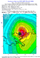
Hurricane Katrina in 2005 also had a big impact on the lake. Strong hurricane-force winds hit the lake's shores for hours after the storm made landfall. This shows how powerful nature can be and why it's important to protect areas around the lake.
Images for kids
-
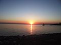
Lake Pontchartrain from the southbound causeway entrance
-
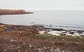
Lake Pontchartrain's north shore at Fontainebleau State Park near Mandeville, Louisiana, in 2004
-
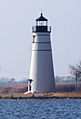
The Madisonville lighthouse, built in 1837, stands at the mouth of the Tchefuncte River where it meets Lake Pontchartrain.
-

Lake Pontchartrain at New Orleans during Hurricane Georges in 1998; lakefront fishing camps outside of the protection levee suffered severe damage.
-
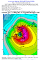
Windspeed of Hurricane Katrina 7 a.m., showing hurricane-force winds hitting the northeast–south shores of Lake Pontchartrain (1 hour after landfall) on August 29, 2005.
-
Windspeed of Hurricane Katrina 10 a.m., showing hurricane-force winds still hitting the north–southeast shores of Lake Pontchartrain (4 hours after landfall)


See also
 In Spanish: Lago Pontchartrain para niños
