Riley County, Kansas facts for kids
Quick facts for kids
Riley County
|
||
|---|---|---|

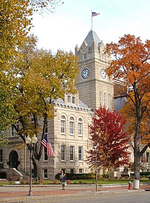
Riley County Courthouse in Manhattan (2005)
|
||
|
||

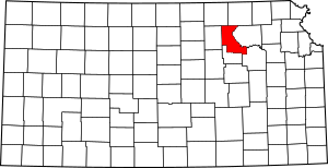
Location within the U.S. state of Kansas
|
||
 Kansas's location within the U.S. |
||
| Country | ||
| State | ||
| Founded | August 25, 1855 | |
| Named for | Bennet C. Riley | |
| Seat | Manhattan | |
| Largest city | Manhattan | |
| Area | ||
| • Total | 622 sq mi (1,610 km2) | |
| • Land | 610 sq mi (1,600 km2) | |
| • Water | 12 sq mi (30 km2) 2.0%% | |
| Population
(2020)
|
||
| • Total | 71,959 | |
| • Estimate
(2021)
|
72,208 |
|
| • Density | 118.0/sq mi (45.6/km2) | |
| Time zone | UTC−6 (Central) | |
| • Summer (DST) | UTC−5 (CDT) | |
| Congressional district | 1st | |
Riley County is a county in the state of Kansas, USA. It's known for being home to Fort Riley, a big U.S. Army base, and Kansas State University. The main city and county seat is Manhattan.
As of 2020, about 71,959 people live in Riley County. The county was named after Bennet C. Riley, who was a general in the Mexican-American War and later the 7th governor of California.
Contents
History of Riley County
Riley County was one of the first 33 counties created in Kansas in August 1855. It was named after General Bennet Riley. At first, Riley County included a lot more land, even parts of what is now Colorado.
The very first capital city of Kansas Territory was located in Riley County. This town was called Pawnee. Today, this area is inside the boundaries of Fort Riley, a U.S. Army post.
Choosing the County Seat
The choice of Manhattan as the county seat was a bit tricky. In 1857, an election was held to pick the county seat. The town of Ogden seemed to win.
However, people in Manhattan thought there might have been cheating in the election. They were able to prove that some votes were cast illegally. Because of this, Manhattan was officially declared the county seat in 1858.
The Irving Tornado
On May 30, 1879, a very strong tornado started in Riley County. It was called the "Irving, Kansas Tornado." Experts believe it was an F4 tornado, which is very powerful.
The tornado's path of damage was about 800 meters wide and 160 kilometers long. Sadly, eighteen people lost their lives, and sixty people were injured.
Geography of Riley County
Riley County covers a total area of about 622 square miles (1,611 square kilometers). Most of this area, about 610 square miles (1,580 square kilometers), is land. The rest, about 12 square miles (31 square kilometers), is water.
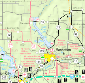
The eastern edge of the county used to follow the Big Blue River. In the 1960s, a dam was built on the river, which created Tuttle Creek Lake. This lake is now a big part of the county's eastern border. Riley County is also part of the beautiful Flint Hills region in Kansas.
Neighboring Counties
Riley County shares its borders with several other counties:
- Marshall County (to the northeast)
- Pottawatomie County (to the east)
- Wabaunsee County (to the southeast)
- Geary County (to the south)
- Clay County (to the west)
- Washington County (to the northwest)
Population Information
| Historical population | |||
|---|---|---|---|
| Census | Pop. | %± | |
| 1860 | 1,224 | — | |
| 1870 | 5,105 | 317.1% | |
| 1880 | 10,430 | 104.3% | |
| 1890 | 13,183 | 26.4% | |
| 1900 | 13,828 | 4.9% | |
| 1910 | 15,783 | 14.1% | |
| 1920 | 20,650 | 30.8% | |
| 1930 | 19,882 | −3.7% | |
| 1940 | 20,617 | 3.7% | |
| 1950 | 33,405 | 62.0% | |
| 1960 | 41,914 | 25.5% | |
| 1970 | 56,788 | 35.5% | |
| 1980 | 63,505 | 11.8% | |
| 1990 | 67,139 | 5.7% | |
| 2000 | 62,843 | −6.4% | |
| 2010 | 71,115 | 13.2% | |
| 2020 | 71,959 | 1.2% | |
| 2023 (est.) | 71,402 | 0.4% | |
| U.S. Decennial Census 1790-1960 1900-1990 1990-2000 2010-2020 |
|||
Riley County is part of the Manhattan, Kansas Metropolitan Statistical Area. This means it's part of a larger urban area. A large number of people in Riley County are between 15 and 34 years old. This is one of the highest rates in the United States.
Education in Riley County
Riley County has several important places for learning.
Colleges and Universities
- Kansas State University: A large public research university.
- Manhattan Christian College: A private Christian college.
- Manhattan Area Technical College: Offers technical and career training.
Local School Districts
Students in Riley County attend schools in these unified school districts:
- Riley County USD 378
- Manhattan-Ogden USD 383
- Blue Valley USD 384
Communities in Riley County
Riley County has several cities and smaller communities. Some communities have parts in a neighboring county.
Cities in Riley County
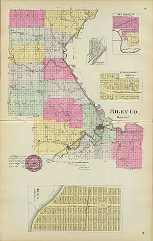
- Leonardville
- Manhattan (the county seat)
- Ogden
- Randolph
- Riley
Unincorporated Communities
These are smaller communities that are not officially cities. Some are also called Census-Designated Places (CDP) by the U.S. Census Bureau.
Former Communities
Some communities in Riley County no longer exist. They were flooded when Tuttle Creek Lake was created in the 1950s and 1960s. The city of Randolph was also flooded, but it was moved to a new location nearby.
- Cleburne
- Garrison Cross
- Stockdale
- Winkler
Fort Riley Military Base
Fort Riley is a large U.S. Army base located mostly in Geary and Riley counties. It covers over 100,000 acres (400 square kilometers). The fort has a daytime population of almost 25,000 people. It is an important part of the local economy and community.
Townships in Riley County
Riley County is divided into fourteen smaller areas called townships. The city of Manhattan is considered separate from the townships for census purposes.
| Township | Population center |
Population | Population density /km2 (/sq mi) |
Land area km2 (sq mi) |
Water area km2 (sq mi) |
Water % | Geographic coordinates |
|---|---|---|---|---|---|---|---|
| Ashland | 150 | 2 (4) | 89 (35) | 1 (0) | 0.75% | 39°6′48″N 96°37′42″W / 39.11333°N 96.62833°W | |
| Bala | Leonardville | 762 | 7 (18) | 108 (42) | 0 (0) | 0.12% | 39°20′34″N 96°53′47″W / 39.34278°N 96.89639°W |
| Center | 81 | 1 (3) | 82 (32) | 0 (0) | 0.04% | 39°29′22″N 96°52′54″W / 39.48944°N 96.88167°W | |
| Fancy Creek | 126 | 2 (4) | 83 (32) | 0 (0) | 0.07% | 39°24′55″N 96°53′14″W / 39.41528°N 96.88722°W | |
| Grant | 833 | 9 (23) | 92 (35) | 7 (3) | 7.38% | 39°17′52″N 96°41′31″W / 39.29778°N 96.69194°W | |
| Jackson | Randolph | 326 | 4 (10) | 84 (32) | 10 (4) | 10.30% | 39°26′43″N 96°45′1″W / 39.44528°N 96.75028°W |
| Madison | Fort Riley CDP (part) | 8,173 | 22 (58) | 366 (141) | 0 (0) | 0.11% | 39°15′32″N 96°50′26″W / 39.25889°N 96.84056°W |
| Manhattan | 3,275 | 37 (95) | 89 (35) | 3 (1) | 3.28% | 39°12′45″N 96°35′46″W / 39.21250°N 96.59611°W | |
| May Day | 78 | 1 (2) | 81 (31) | 0 (0) | 0.04% | 39°32′39″N 96°53′41″W / 39.54417°N 96.89472°W | |
| Ogden | Ogden | 2,423 | 69 (178) | 35 (14) | 1 (0) | 2.32% | 39°7′6″N 96°41′54″W / 39.11833°N 96.69833°W |
| Sherman | 524 | 7 (18) | 76 (29) | 5 (2) | 6.06% | 39°22′30″N 96°43′58″W / 39.37500°N 96.73278°W | |
| Swede Creek | Cleburne (hist.) | 157 | 1 (3) | 125 (48) | 4 (1) | 3.00% | 39°32′24″N 96°42′9″W / 39.54000°N 96.70250°W |
| Wildcat | 750 | 10 (25) | 77 (30) | 0 (0) | 0.10% | 39°13′26″N 96°42′28″W / 39.22389°N 96.70778°W | |
| Zeandale | 357 | 2 (6) | 154 (60) | 2 (1) | 0.97% | 39°7′39″N 96°27′19″W / 39.12750°N 96.45528°W |
Notable People from Riley County
Many interesting people have lived in or are from Riley County. Some of them include:
- John W. Carlin: A former Governor of Kansas.
- Glen Edgerton: A General.
- Horace A. W. Tabor: A very rich miner.
- Jordy Nelson: A famous NFL football player.
See also
 In Spanish: Condado de Riley para niños
 | Emma Amos |
 | Edward Mitchell Bannister |
 | Larry D. Alexander |
 | Ernie Barnes |


