
Washington County, Kansas facts for kids
Quick facts for kids
Washington County
|
|
|---|---|

Washington County Courthouse in Washington (2015)
|
|

Location within the U.S. state of Kansas
|
|
 Kansas's location within the U.S. |
|
| Country | |
| State | |
| Founded | February 20, 1857 |
| Named for | George Washington |
| Seat | Washington |
| Largest city | Washington |
| Area | |
| • Total | 899 sq mi (2,330 km2) |
| • Land | 895 sq mi (2,320 km2) |
| • Water | 3.9 sq mi (10 km2) 0.4% |
| Population
(2020)
|
|
| • Total | 5,530 |
| • Estimate
(2023)
|
5,504 |
| • Density | 6.151/sq mi (2.375/km2) |
| Time zone | UTC−6 (Central) |
| • Summer (DST) | UTC−5 (CDT) |
| Area code | 785 |
| Congressional district | 1st |
Washington County is a county in the state of Kansas. The main city and county seat is Washington. In 2020, about 5,530 people lived here. The county is named after George Washington, who was the first president of the United States.
Contents
History of Washington County
Early History of the Area
For thousands of years, the Great Plains of North America were home to nomadic Native American tribes. These tribes moved around, often following the huge herds of buffalo. Many different tribes lived here, including the Arapaho, Cheyenne, Comanche, Sioux, Ute, Otoe, Kansa, Kiowa, Osage, Omaha, Ponca, Pawnee, and Wichita.
From the 1500s to the 1700s, France claimed large parts of North America. After a war in 1762, France secretly gave this land to Spain.
The 1800s
In 1802, Spain gave most of the land back to France. Then, in 1803, the United States bought a huge area, including most of what is now Kansas, from France. This was part of the Louisiana Purchase. It was a very large area, about 828,000 square miles!
In 1854, the Kansas Territory was created. Kansas then became the 34th U.S. state in 1861. Washington County was officially started in 1857. Important routes like the Oregon-California Trail, the Overland Stage Line, and the Pony Express all passed through Washington County. The Hollenberg Way Station, a stop for travelers, was open from 1857 to 1872 in the northeast part of the county.
The 2000s
In 2010, the Keystone-Cushing Pipeline was built through Washington County. There were some worries about taxes and the environment. On December 7, 2022, the pipeline had to be shut down because of a leak near the community of Washington. It was fixed and reopened on December 29, 2022.
Geography
Washington County covers a total area of about 899 square miles. Most of this, about 895 square miles, is land. Only a small part, about 3.9 square miles (0.4%), is water.
Neighboring Counties
Washington County shares borders with these counties:
- Jefferson County, Nebraska (north)
- Gage County, Nebraska (northeast)
- Marshall County (east)
- Riley County (southeast)
- Clay County (south)
- Cloud County (southwest)
- Republic County (west)
- Thayer County, Nebraska (northwest)
Population Information

| Historical population | |||
|---|---|---|---|
| Census | Pop. | %± | |
| 1860 | 383 | — | |
| 1870 | 4,081 | 965.5% | |
| 1880 | 14,910 | 265.4% | |
| 1890 | 22,894 | 53.5% | |
| 1900 | 21,963 | −4.1% | |
| 1910 | 20,229 | −7.9% | |
| 1920 | 17,984 | −11.1% | |
| 1930 | 17,112 | −4.8% | |
| 1940 | 15,921 | −7.0% | |
| 1950 | 12,977 | −18.5% | |
| 1960 | 10,739 | −17.2% | |
| 1970 | 9,249 | −13.9% | |
| 1980 | 8,543 | −7.6% | |
| 1990 | 7,073 | −17.2% | |
| 2000 | 6,483 | −8.3% | |
| 2010 | 5,799 | −10.6% | |
| 2020 | 5,530 | −4.6% | |
| 2023 (est.) | 5,504 | −5.1% | |
| U.S. Decennial Census 1790-1960 1900-1990 1990-2000 2010-2020 |
|||
In 2000, there were 6,483 people living in Washington County. There were 2,673 households and 1,780 families. The county had about 7 people per square mile.
About 26.6% of households had children under 18 living with them. Most households (59.4%) were married couples. About 31.2% of all households were people living alone. Also, 17.8% of households had someone aged 65 or older living alone.
The average age in the county was 44 years old. About 23.7% of the population was under 18. About 25.1% were 65 years or older.
The average income for a household in the county was $29,363. For families, the average income was $37,260. About 10.1% of all people in the county lived below the poverty line. This included 12.2% of those under 18 and 12.4% of those 65 or older.
Education
Students in Washington County attend schools run by these districts:
- Washington County USD 108
- Barnes–Hanover–Linn USD 223
Some students may also attend schools in a district with an office in a neighboring county:
- Clifton–Clyde USD 224
Communities
Here is a list of cities and towns in Washington County.
Cities
‡ means a community has parts in a county next door.
- Barnes
- Clifton‡
- Greenleaf
- Haddam
- Hanover
- Hollenberg
- Linn
- Mahaska
- Morrowville
- Palmer
- Vining‡
- Washington (the main city and county seat)
Unincorporated Communities
These are places that are not officially organized as cities or towns.
Ghost Towns
These are towns that no longer exist or are abandoned.
- Strawberry
Images for kids
-
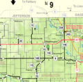
A map of Washington County, Kansas, from 2005.

See also
 In Spanish: Condado de Washington (Kansas) para niños
