Lanham, Kansas and Nebraska facts for kids
Quick facts for kids
Lanham, Kansas and Nebraska
|
|
|---|---|

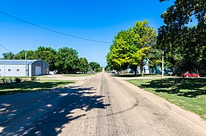
West State Line Road in Lanham. Left side is Kansas, right side is Nebraska. (2017)
|
|
| Country | United States |
| State | Kansas, Nebraska |
| County KS NE | Washington, Kansas, Gage, Nebraska |
| Elevation | 1,398 ft (426 m) |
| Time zone | UTC-6 (CST) |
| • Summer (DST) | UTC-5 (CDT) |
| ZIP code |
66945, 68415
|
| FIPS code | 31-38625 |
| GNIS ID | 485447 |
Lanham is a small community that's unique because it sits right on the border between two states: Kansas and Nebraska! Part of Lanham is in Washington County, Kansas, and the other part is in Gage County, Nebraska. This means it's an unincorporated community, which is a place that doesn't have its own local government. Imagine having your main street be the actual state line! It's located along State Line Road, not far from highways K-148 and Nebraska Highway 112. It's also about 7 miles north of Hanover, Kansas, and 6.5 miles from Odell, Nebraska.
A Look Back: History of Lanham
Lanham got its name from someone important who worked for the railroad. Back in 1914, a post office opened in the Kansas part of Lanham. People could send and receive mail there. However, it only stayed open for about nine years, closing in 1923.
Learning in Lanham
For students living in the Kansas part of Lanham and the nearby countryside, public schools are managed by the Barnes–Hanover–Linn USD 223 school district. This district helps make sure kids in the area get their education.
 | Victor J. Glover |
 | Yvonne Cagle |
 | Jeanette Epps |
 | Bernard A. Harris Jr. |


