Jefferson County, Nebraska facts for kids
Quick facts for kids
Jefferson County
|
|
|---|---|

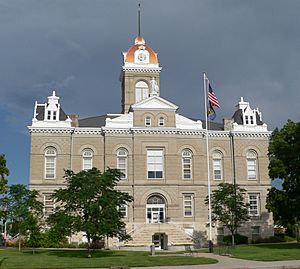
Jefferson County Courthouse in Fairbury
|
|

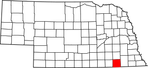
Location within the U.S. state of Nebraska
|
|
 Nebraska's location within the U.S. |
|
| Country | |
| State | |
| Founded | January 26, 1856 (founded) 1864 (organized) |
| Named for | Thomas Jefferson |
| Seat | Fairbury |
| Largest city | Fairbury |
| Area | |
| • Total | 576 sq mi (1,490 km2) |
| • Land | 570 sq mi (1,500 km2) |
| • Water | 5.5 sq mi (14 km2) 1.0%% |
| Population
(2020)
|
|
| • Total | 7,240 |
| • Estimate
(2021)
|
7,176 |
| • Density | 12.569/sq mi (4.853/km2) |
| Time zone | UTC−6 (Central) |
| • Summer (DST) | UTC−5 (CDT) |
| Congressional district | 3rd |
Jefferson County is a county in the state of Nebraska, USA. As of 2020, about 7,240 people live there. The main town, or county seat, is Fairbury. The county is named after Thomas Jefferson, who was the third President of the United States of America. If you look at Nebraska license plates, Jefferson County is shown by the number 33. This is because it had the 33rd largest number of cars registered when the system started in 1922.
Contents
History of Jefferson County
Jefferson County was officially created on January 26, 1856. Its local government started working in 1864. It was named in honor of Thomas Jefferson, a very important early American leader. He served as the third president of the United States.
In 2010, a large oil pipeline, called the Keystone-Cushing Pipeline (Phase II), was built. It runs south from Jefferson County.
Geography of Jefferson County
Jefferson County is located in the southern part of Nebraska. Its southern border touches the northern border of Kansas. The land in Jefferson County has gentle, rolling hills. The flat tops of these hills are mostly used for farming. The Little Blue River flows through the middle of the county, heading southeast. The county covers a total area of 576 square miles. Most of this (570 square miles) is land, and a small part (5.5 square miles) is water.
Main Roads in Jefferson County
Special Nature Areas
- Alexandria State Recreation Area
- Buckley State Recreation Area
- Rock Creek Station State Historical Park
- Rock Glen State Wildlife Management Area
Neighboring Counties
- Saline County - to the north
- Gage County - to the east
- Washington County, Kansas - to the south
- Republic County, Kansas - to the southwest
- Thayer County - to the west
- Fillmore County - to the northwest
Population Information
| Historical population | |||
|---|---|---|---|
| Census | Pop. | %± | |
| 1870 | 2,440 | — | |
| 1880 | 8,096 | 231.8% | |
| 1890 | 14,850 | 83.4% | |
| 1900 | 15,196 | 2.3% | |
| 1910 | 16,852 | 10.9% | |
| 1920 | 16,140 | −4.2% | |
| 1930 | 16,409 | 1.7% | |
| 1940 | 15,532 | −5.3% | |
| 1950 | 13,623 | −12.3% | |
| 1960 | 11,620 | −14.7% | |
| 1970 | 10,436 | −10.2% | |
| 1980 | 9,817 | −5.9% | |
| 1990 | 8,759 | −10.8% | |
| 2000 | 8,333 | −4.9% | |
| 2010 | 7,547 | −9.4% | |
| 2020 | 7,240 | −4.1% | |
| 2021 (est.) | 7,176 | −4.9% | |
| US Decennial Census 1790-1960 1900-1990 1990-2000 2010-2013 |
|||
In 2020, the population of Jefferson County was 7,240 people. The number of people living in the county has changed over the years. For example, in 1900, there were about 15,196 people. By 2010, the population was 7,547.
Towns and Villages
Jefferson County has one main city and several smaller villages and communities.
City
- Fairbury (This is the county seat, where the main government offices are.)
Villages
Unincorporated communities
See also
 In Spanish: Condado de Jefferson (Nebraska) para niños
 | Laphonza Butler |
 | Daisy Bates |
 | Elizabeth Piper Ensley |

