Washington, Kansas facts for kids
Quick facts for kids
Washington, Kansas
|
|
|---|---|
|
City and County seat
|
|

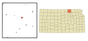
Location within Washington County and Kansas
|
|

|
|
| Country | United States |
| State | Kansas |
| County | Washington |
| Founded | 1860 |
| Incorporated | 1875 |
| Named for | George Washington |
| Area | |
| • Total | 1.01 sq mi (2.62 km2) |
| • Land | 0.97 sq mi (2.52 km2) |
| • Water | 0.04 sq mi (0.10 km2) |
| Elevation | 1,319 ft (402 m) |
| Population
(2020)
|
|
| • Total | 1,071 |
| • Density | 1,060/sq mi (408.8/km2) |
| Time zone | UTC-6 (CST) |
| • Summer (DST) | UTC-5 (CDT) |
| ZIP code |
66968
|
| Area code | 785 |
| FIPS code | 20-75825 |
| GNIS ID | 485656 |
Washington is a city located in Washington County, Kansas, in the United States. It is also the county seat, which means it's the main town where the county government is located. In 2020, about 1,071 people lived in Washington.
Contents
History of Washington, Kansas
Washington was started in the spring of 1860. In the same year, it was chosen to be the county seat. During the American Civil War, the town was protected by two special buildings. These were the Washington Company House and Woolbert's Stockade Hotel. They had strong walls to keep people safe.
The first post office in Washington opened in November 1861. This made it easier for people to send and receive letters.
Geography and Climate
Where is Washington Located?
The city of Washington covers a total area of about 0.91 square miles (2.36 km2). Most of this area, about 0.87 square miles (2.25 km2), is land. The rest, about 0.04 square miles (0.10 km2), is water.
Washington's Climate
Washington has a type of weather called a humid subtropical climate. This means it usually has hot, humid summers and mild winters. It can get quite warm here. The hottest temperature ever recorded was 112 °F (44.4 °C) on July 12, 1954. It can also get very cold. The coldest temperature was −29 °F (−33.9 °C), recorded on December 23, 1989, and again on February 16, 2021.
| Climate data for Washington, Kansas, 1991–2020 normals, extremes 1893–present | |||||||||||||
|---|---|---|---|---|---|---|---|---|---|---|---|---|---|
| Month | Jan | Feb | Mar | Apr | May | Jun | Jul | Aug | Sep | Oct | Nov | Dec | Year |
| Record high °F (°C) | 75 (24) |
85 (29) |
90 (32) |
98 (37) |
103 (39) |
107 (42) |
112 (44) |
110 (43) |
107 (42) |
97 (36) |
84 (29) |
73 (23) |
112 (44) |
| Mean maximum °F (°C) | 60.8 (16.0) |
67.3 (19.6) |
78.9 (26.1) |
86.2 (30.1) |
91.9 (33.3) |
96.8 (36.0) |
101.6 (38.7) |
100.0 (37.8) |
95.2 (35.1) |
88.0 (31.1) |
73.3 (22.9) |
62.6 (17.0) |
102.8 (39.3) |
| Mean daily maximum °F (°C) | 37.2 (2.9) |
42.6 (5.9) |
54.5 (12.5) |
64.9 (18.3) |
74.9 (23.8) |
85.4 (29.7) |
90.3 (32.4) |
87.9 (31.1) |
80.5 (26.9) |
67.8 (19.9) |
52.5 (11.4) |
40.2 (4.6) |
64.9 (18.3) |
| Daily mean °F (°C) | 26.1 (−3.3) |
30.5 (−0.8) |
41.5 (5.3) |
52.1 (11.2) |
63.3 (17.4) |
73.9 (23.3) |
78.8 (26.0) |
76.0 (24.4) |
67.6 (19.8) |
54.6 (12.6) |
40.4 (4.7) |
29.6 (−1.3) |
52.9 (11.6) |
| Mean daily minimum °F (°C) | 15.0 (−9.4) |
18.4 (−7.6) |
28.4 (−2.0) |
39.2 (4.0) |
51.7 (10.9) |
62.4 (16.9) |
67.2 (19.6) |
64.0 (17.8) |
54.7 (12.6) |
41.4 (5.2) |
28.3 (−2.1) |
19.0 (−7.2) |
40.8 (4.9) |
| Mean minimum °F (°C) | −4.4 (−20.2) |
0.9 (−17.3) |
11.0 (−11.7) |
24.6 (−4.1) |
36.6 (2.6) |
50.1 (10.1) |
56.1 (13.4) |
53.9 (12.2) |
39.5 (4.2) |
25.3 (−3.7) |
14.1 (−9.9) |
1.9 (−16.7) |
−8.4 (−22.4) |
| Record low °F (°C) | −24 (−31) |
−29 (−34) |
−18 (−28) |
5 (−15) |
28 (−2) |
40 (4) |
44 (7) |
43 (6) |
26 (−3) |
13 (−11) |
−6 (−21) |
−29 (−34) |
−29 (−34) |
| Average precipitation inches (mm) | 0.79 (20) |
1.14 (29) |
1.80 (46) |
3.14 (80) |
4.44 (113) |
4.74 (120) |
4.13 (105) |
4.26 (108) |
3.07 (78) |
2.18 (55) |
1.49 (38) |
1.23 (31) |
32.41 (823) |
| Average snowfall inches (cm) | 4.6 (12) |
4.6 (12) |
1.4 (3.6) |
0.3 (0.76) |
0.0 (0.0) |
0.0 (0.0) |
0.0 (0.0) |
0.0 (0.0) |
0.0 (0.0) |
0.1 (0.25) |
1.0 (2.5) |
2.4 (6.1) |
14.4 (37.21) |
| Average precipitation days (≥ 0.01 in) | 4.6 | 4.7 | 6.5 | 8.8 | 11.0 | 9.8 | 8.6 | 8.2 | 6.8 | 6.8 | 5.3 | 4.5 | 85.6 |
| Average snowy days (≥ 0.1 in) | 2.9 | 2.3 | 1.2 | 0.3 | 0.0 | 0.0 | 0.0 | 0.0 | 0.0 | 0.2 | 1.0 | 2.2 | 10.1 |
| Source 1: NOAA | |||||||||||||
| Source 2: National Weather Service | |||||||||||||
People of Washington
Population Changes Over Time
The number of people living in Washington has changed over many years. This table shows how the population has grown and shrunk since 1880.
| Historical population | |||
|---|---|---|---|
| Census | Pop. | %± | |
| 1880 | 675 | — | |
| 1890 | 1,613 | 139.0% | |
| 1900 | 1,575 | −2.4% | |
| 1910 | 1,547 | −1.8% | |
| 1920 | 1,406 | −9.1% | |
| 1930 | 1,370 | −2.6% | |
| 1940 | 1,598 | 16.6% | |
| 1950 | 1,527 | −4.4% | |
| 1960 | 1,506 | −1.4% | |
| 1970 | 1,584 | 5.2% | |
| 1980 | 1,488 | −6.1% | |
| 1990 | 1,304 | −12.4% | |
| 2000 | 1,223 | −6.2% | |
| 2010 | 1,131 | −7.5% | |
| 2020 | 1,071 | −5.3% | |
| U.S. Decennial Census | |||
Who Lives in Washington? (2010 Census)
In 2010, there were 1,131 people living in Washington. These people lived in 512 households, with 311 of them being families. Most residents, about 97.8%, were White. A small number were African American, Native American, or Asian. About 2.3% of the population were Hispanic or Latino.
About 26% of households had children under 18 living there. Many households, 52.3%, were married couples. About 39.3% of households were not families, meaning people lived alone or with roommates. The average age in the city was 46.8 years old. About 21.8% of residents were under 18, and 25.9% were 65 or older. The city had slightly more females (52.9%) than males (47.1%).
Education in Washington
The schools in Washington are part of the Washington County USD 108 public school district. This district was created in 2006 when two smaller school districts joined together.
Notable People from Washington
- Charlie Becker (1887–1968) – He was an actor who played the mayor of Munchkinland in the famous 1939 movie The Wizard of Oz.
- Bill Pannbacker – He used to be a member of the Kansas House of Representatives, which is part of the state government.
See also
 In Spanish: Washington (Kansas) para niños
 | Emma Amos |
 | Edward Mitchell Bannister |
 | Larry D. Alexander |
 | Ernie Barnes |

