Tuttle Creek Lake facts for kids
Quick facts for kids Tuttle Creek Lake |
|
|---|---|
Tuttle Creek Dam
|
|
|
|
| Location | Pottawatomie / Riley / Marshall counties in Kansas |
| Coordinates | 39°15′25″N 96°35′32″W / 39.25694°N 96.59222°W |
| Type | Reservoir |
| Primary inflows | Big Blue River |
| Primary outflows | Big Blue River to Kansas River |
| Catchment area | 25,000 km² (9,600 mi²) |
| Basin countries | United States |
| Max. length | 25 km (16 mi) |
| Max. width | 2 km (1.3 mi) |
| Surface area | 50 km² (19 mi²) |
| Max. depth | 15 m (50 ft) |
| Water volume | 0.41 km3 (0.098 cu mi) (normal level) |
| Shore length1 | 160 km (100 mi) |
| Surface elevation | 328 m (1075 ft) |
| Settlements | Manhattan |
| 1 Shore length is not a well-defined measure. | |
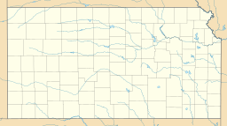
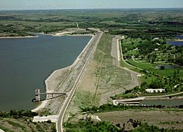
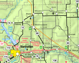
Tuttle Creek Lake is a large reservoir (an artificial lake) in northeast Kansas. It's located about 5 miles (8 km) north of Manhattan in the beautiful Flint Hills region. The Army Corps of Engineers built and manages this lake. Its main job is to control floods.
But Tuttle Creek Lake also helps in other ways! It keeps water levels good for boats on the Mississippi River, creates a fun place for fishing, hunting, and boating, and makes sure towns downstream have clean water. Right next to the dam is Tuttle Creek State Park. This park has over 1,200 acres (4.9 km²) of fun areas, including nature trails, camping spots, and a sandy beach.
Contents
About Tuttle Creek Lake
Tuttle Creek Lake manages the water from the entire Big Blue River area. This area stretches from just north of Manhattan all the way to the Platte River. It covers a huge space of about 9,628 square miles (24,936 km²).
The lake sits on the border between Riley County (on the west) and Pottawatomie County (on the east). Kansas Highway 13 crosses the dam, which is about two miles north of Manhattan. Further north, where the river flows into the lake, Kansas Highway 16 crosses the water on a bridge.
History of the Dam
From 1903 to 1959, the Kansas River area, including cities like Topeka, suffered from 25 floods. But there were also times of very dry weather. As more people moved to the area and industries grew, there was a need for a project to control floods and save water for dry periods.
Building the Dam
The Flood Control Act of 1938 first approved the idea of building Tuttle Creek Reservoir. Money for planning was set aside in 1944. The construction of Tuttle Creek Dam became very important after the Great Flood of 1951. This flood covered downtown Manhattan, Topeka, and parts of Kansas City. The total damage to cities and farms in Kansas was over $725,000,000.
Even with the flood damage, many landowners whose land would be flooded by the new lake were against the project. People in the Blue Valley organized and said, "Let's quit this dam foolishness." This led to Howard Shultz Miller winning a seat in the U.S. House of Representatives in 1952. But even with strong opposition, the dam was eventually built.
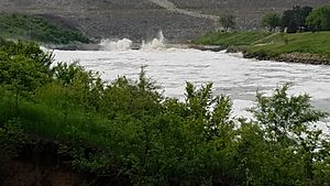
Construction started in 1952. On July 4, 1959, the dam was closed (even though it wasn't finished). The river was sent through the completed intake tower, which people call "The Tubes." In 1960, the unfinished dam held back a record amount of melted snow. It was credited with preventing $15,243,000 in damages! During this event, the tubes released 29,000 cubic feet per second (821 m³/s) of water. This record wasn't broken until May 31, 2019, when they released an estimated 30,000 cubic feet per second (850 m³/s).
When the dam was finished and the lake started filling up in 1962, it covered ten towns. Four towns were completely submerged: Cleburne, Randolph, Garrison Cross, and Stockdale. Only Randolph was rebuilt in a new location. The streets in the new Randolph are named after the towns that were covered by the lake. You can still see parts of "Old Randolph" underwater today.
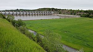
The dam proved how valuable it was during the Great Flood of 1993. Floodwaters rose up to 63 feet (19 m) above normal, but the dam held them back. However, when the dam reached its full capacity in July 1993, it had to use its spillway for the first time. All 18 gates on the spillway were lifted 4 feet (1.2 m), releasing 60,000 cubic feet per second (1,700 m³/s) of water (the tubes were closed then).
This controlled release still caused some flooding in low-lying homes and farms. But it was much less than the 96,000 cubic feet per second (2,718 m³/s) that would have flooded downtown Manhattan if the dam hadn't been there. The sound of the water was so loud it could be heard half a mile (800 m) away!
Spillway Erosion and Repair
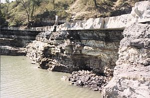
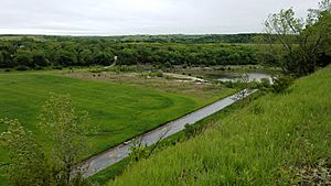
After three weeks of water release in 1993, the spillway gates were closed. This revealed over 32 acres (13 ha) of newly exposed rock formations. This amazing sight became known as the Little Grand Canyon or "The Canyon."
How the Erosion Happened
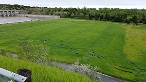
Below the gates, there's a 600-foot (183 m) concrete channel, followed by about 7,000 feet (2,134 m) of unlined channel that used to be covered in grass. The dam was designed so that the unlined channel would erode during a spillway release. As expected, the water quickly washed away all the soil and then a few feet of loose, weathered rock. This exposed strong limestone layers.
These limestone layers experienced "head cutting." This is when the softer rock underneath (shale) erodes away, causing the limestone above to weaken, break off, and wash away. This process is much slower than the initial removal of loose material.
Each of these headcuts has a tough limestone layer on top and easily eroded shale underneath. Two very strong limestone formations created noticeable cliffs. The limestone layers of the Red Eagle Formation formed a 26-foot (8 m) cliff. From the bottom of that cliff, 4.5 acres (1.8 ha) of the Long Creek limestone bed of the Foraker Formation stretched out (now covered by a beaver dam).
Geologic Discoveries
This area is very interesting for geologists (scientists who study rocks and Earth). It shows off 300-million-year-old rocks from the late Carboniferous and early Permian periods, which are usually hidden. In this one spot, you can study five different rock formations that are rarely seen so clearly all together.
These rock layers show that the area used to be a flat, dry environment along the western edge of a supercontinent called Pangaea. Sometimes, the ocean would cover the land. This was similar to the Persian Gulf coast today. As sea levels rose and fell over thousands of years, the environment changed. This created repeating layers of rock, like a "layer cake," which are special to this ancient time. When sea levels were high, limestone and shale were deposited. When sea levels were low, red and green clays and ancient soils were left behind.
Repairing the Spillway
Even though the exposed rocks in 1993 were impressive, there was concern about how well the spillway would hold up in future water releases. Scientists studied the bedrock to decide if it needed repairs or reinforcement.
During the 1993 spillway release, photos were taken every day at nine different spots to measure how fast the head cutting was happening. Analysis showed that the spillway could handle 10 times the amount of water released in 1993. This is the maximum amount the spillway was designed to release (612,000 cubic feet per second or 17,330 m³/s).
However, a rock layer called Roca Shale, which had been hidden before, was now exposed. Even though it held up well during the flood, it was expected to break down quickly if left open to Kansas weather. So, it was decided to make minimal repairs to the upper part of the channel. Weaker and cracked limestone layers were filled with grout and then strengthened with shotcrete (a type of concrete sprayed on). Then, the area was covered with terraced soil and replanted with grass. The soil's pH was adjusted to protect the reburied rock even more. The rock formations in the lower part of the spillway were left exposed.
Earthquake Threat and Safety
Kansas isn't usually known for earthquakes. However, the Humboldt fault line, which is part of the Nemaha Ridge, runs through eastern Kansas. The most active part of this fault line is near Tuttle Creek Lake. Studies starting in the 1980s showed that the ground in the area could potentially cause an earthquake strong enough to damage the dam. If the dam were to fail, it could put thousands of lives at risk in the Blue River and Kansas River valleys downstream.
To make the dam safer, the Army Corps of Engineers finished a project in July 2010. They reinforced the dam with over 350 concrete walls. These walls help stop water from flowing through cracks in the underlying karst (a type of rock formation). They also added warning sensors to the dam to monitor its condition.
 | Audre Lorde |
 | John Berry Meachum |
 | Ferdinand Lee Barnett |


