
Pottawatomie County, Kansas facts for kids
Quick facts for kids
Pottawatomie County
|
|
|---|---|

Pottawatomie County Courthouse in Westmoreland (2009)
|
|

Location within the U.S. state of Kansas
|
|
 Kansas's location within the U.S. |
|
| Country | |
| State | |
| Founded | February 20, 1857 |
| Named for | Potawatomi tribe |
| Seat | Westmoreland |
| Largest city | Manhattan |
| Area | |
| • Total | 862 sq mi (2,230 km2) |
| • Land | 841 sq mi (2,180 km2) |
| • Water | 21 sq mi (50 km2) 2.4%% |
| Population
(2020)
|
|
| • Total | 25,348 |
| • Estimate
(2023)
|
26,382 |
| • Density | 30.1/sq mi (11.6/km2) |
| Time zone | UTC−6 (Central) |
| • Summer (DST) | UTC−5 (CDT) |
| Congressional district | 1st |
Pottawatomie County is a county located in the state of Kansas. Its main town, called the county seat, is Westmoreland. In 2020, about 25,348 people lived here. The county got its name from the Potawatomi Native American tribe.
Contents
History
Early Kansas History
For thousands of years, the Great Plains of North America were home to nomadic Native American tribes. These groups moved around to hunt and find food.
From the 1500s to the 1700s, France claimed large parts of North America. In 1762, after a big war, France secretly gave its land, called New France, to Spain. This was part of a deal known as the Treaty of Fontainebleau.
The 1800s
In 1802, Spain gave most of this land back to France. Then, in 1803, the United States bought a huge area of land from France. This was called the Louisiana Purchase. Most of what is now Kansas was part of this purchase.
In 1854, the Kansas Territory was set up. This happened because of a law called the Kansas–Nebraska Act. Later, in 1861, Kansas officially became the 34th U.S. state.
Pottawatomie County was created in 1857 by the Kansas government. It was formed from land that used to be part of Riley County. The town of Westmoreland was chosen as the county seat in 1882 after a vote.
Geography
The U.S. Census Bureau says that Pottawatomie County covers about 862 square miles. Most of this area, about 841 square miles, is land. The rest, about 21 square miles, is water. This means about 2.4% of the county is water.
Neighboring Counties
Pottawatomie County shares borders with several other counties:
- Marshall County to the north
- Nemaha County to the northeast
- Jackson County to the east
- Shawnee County to the southeast
- Wabaunsee County to the south
- Riley County to the west
Demographics

| Historical population | |||
|---|---|---|---|
| Census | Pop. | %± | |
| 1860 | 1,529 | — | |
| 1870 | 7,848 | 413.3% | |
| 1880 | 16,350 | 108.3% | |
| 1890 | 17,722 | 8.4% | |
| 1900 | 18,470 | 4.2% | |
| 1910 | 17,522 | −5.1% | |
| 1920 | 16,154 | −7.8% | |
| 1930 | 15,862 | −1.8% | |
| 1940 | 14,015 | −11.6% | |
| 1950 | 12,344 | −11.9% | |
| 1960 | 11,957 | −3.1% | |
| 1970 | 11,755 | −1.7% | |
| 1980 | 14,782 | 25.8% | |
| 1990 | 16,128 | 9.1% | |
| 2000 | 18,209 | 12.9% | |
| 2010 | 21,604 | 18.6% | |
| 2020 | 25,348 | 17.3% | |
| 2023 (est.) | 26,382 | 22.1% | |
| U.S. Decennial Census 1790-1960 1900-1990 1990-2000 2010-2020 |
|||
Pottawatomie County is part of the Manhattan area. This area is known as the Manhattan Metropolitan Statistical Area.
In 2000, there were 18,209 people living in the county. There were 6,771 households, which are groups of people living together. About 4,929 of these were families. The population density was about 22 people per square mile.
The population was spread out by age. About 29.5% of people were under 18 years old. About 13.5% were 65 years or older. The average age in the county was 36 years old.
Education

Pottawatomie County has several school districts. These are called Unified School Districts (USDs). They manage public schools in the area.
Unified School Districts
The main school districts in Pottawatomie County are:
- Wamego USD 320
- Kaw Valley USD 321
- Onaga USD 322
- Rock Creek USD 323
Some school districts that serve parts of Pottawatomie County have their main offices in neighboring counties:
- Riley County USD 378
- Manhattan–Ogden USD 383
- Blue Valley USD 384
- Valley Heights USD 498
- Vermillion USD 380
Private Schools
There are also private schools in the county:
- St. Marys Academy & College (in St. Marys)
- Flint Hills Christian School (in Manhattan)
Communities

Pottawatomie County has several cities and smaller communities.
Cities
Some cities might have parts in a neighboring county.
- Belvue
- Emmett
- Havensville
- Louisville
- Manhattan (most of it is in Riley County)
- Olsburg
- Onaga
- St. George
- St. Marys
- Wamego
- Westmoreland (This is the county seat)
- Wheaton
Unincorporated Communities
These are smaller towns or villages that do not have their own city government.
Former Communities
Before Tuttle Creek Lake was built, there was a community called Garrison in the western part of Pottawatomie County. It no longer exists.
Images for kids
-
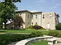
Pottawatomie County Courthouse in Westmoreland (2009)
-
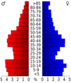
Population pyramid based on 2000 census age data
-
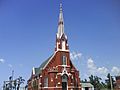
St. Columbkillane Church in Blaine
-
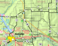
2005 map of Pottawatomie County (map legend)
See also
 In Spanish: Condado de Pottawatomie (Kansas) para niños
