Jackson County, Kansas facts for kids
Quick facts for kids
Jackson County
|
|
|---|---|

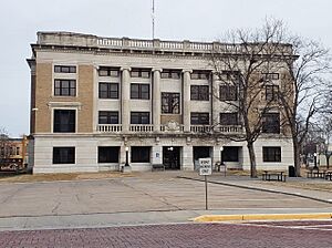
Jackson County Courthouse in Holton (2023)
|
|

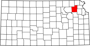
Location within the U.S. state of Kansas
|
|
 Kansas's location within the U.S. |
|
| Country | |
| State | |
| Founded | February 11, 1859 |
| Named for | Andrew Jackson |
| Seat | Holton |
| Largest city | Holton |
| Area | |
| • Total | 658 sq mi (1,700 km2) |
| • Land | 656 sq mi (1,700 km2) |
| • Water | 1.8 sq mi (5 km2) 0.3%% |
| Population
(2020)
|
|
| • Total | 13,232 |
| • Density | 20.2/sq mi (7.8/km2) |
| Time zone | UTC−6 (Central) |
| • Summer (DST) | UTC−5 (CDT) |
| Congressional districts | 1st, 2nd |
Jackson County is a county located in the state of Kansas in the United States. Its main city and county seat is Holton. A county seat is like the main office for the county's government.
In 2020, about 13,232 people lived in Jackson County. The county was first named Calhoun County. It was named after John C. Calhoun, a senator from South Carolina. Later, in 1859, it was renamed after President Andrew Jackson.
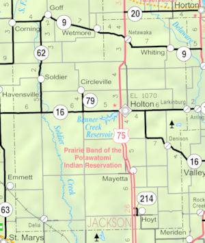
A part of the Prairie Band Potawatomi Indian Reservation is also located in Jackson County. This reservation covers about 18.5% of the county's total area.
Contents
History of Jackson County
Early Beginnings
For thousands of years, the Great Plains of North America were home to nomadic Native Americans. These groups moved around to hunt and find food.
In the 16th to 18th centuries, the country of France claimed large parts of North America. This included the land that is now Kansas. After a war called the French and Indian War, France secretly gave this land to Spain in 1762. This was part of a deal called the Treaty of Fontainebleau.
19th Century Changes
In 1802, Spain gave most of this land back to France. However, Spain kept about 7,500 square miles (19,425 square kilometers).
Then, in 1803, the United States bought a huge amount of land from France. This was part of the Louisiana Purchase. It included most of what is now Kansas. The U.S. paid about 2.83 cents for each acre of land. This was a very big deal for the young country!
In 1854, the Kansas Territory was created. This was a step toward Kansas becoming a state. Finally, in 1861, Kansas officially became the 34th state in the U.S. Jackson County was officially formed in 1859.
Geography of Jackson County
Jackson County covers about 658 square miles (1,704 square kilometers). Most of this area is land, about 656 square miles (1,699 square kilometers). Only a small part, about 1.8 square miles (4.7 square kilometers), is water.
Neighboring Counties
Jackson County shares its borders with several other counties:
- Brown County (to the northeast)
- Atchison County (to the east)
- Jefferson County (to the southeast)
- Shawnee County (to the south)
- Pottawatomie County (to the west)
- Nemaha County (to the northwest)
People of Jackson County
Jackson County is part of the Topeka area. This means it's connected to the larger city of Topeka.
The county's population has changed over the years:
| Historical population | |||
|---|---|---|---|
| Census | Pop. | %± | |
| 1860 | 1,936 | — | |
| 1870 | 6,053 | 212.7% | |
| 1880 | 10,718 | 77.1% | |
| 1890 | 14,626 | 36.5% | |
| 1900 | 17,117 | 17.0% | |
| 1910 | 16,861 | −1.5% | |
| 1920 | 15,495 | −8.1% | |
| 1930 | 14,776 | −4.6% | |
| 1940 | 13,382 | −9.4% | |
| 1950 | 11,098 | −17.1% | |
| 1960 | 10,309 | −7.1% | |
| 1970 | 10,342 | 0.3% | |
| 1980 | 11,644 | 12.6% | |
| 1990 | 11,525 | −1.0% | |
| 2000 | 12,657 | 9.8% | |
| 2010 | 13,462 | 6.4% | |
| 2020 | 13,232 | −1.7% | |
| 2023 (est.) | 13,368 | −0.7% | |
| U.S. Decennial Census | |||
In 2000, there were about 12,657 people living in the county. The population density was about 19 people per square mile. Most people (about 90%) were White. About 7% were Native American. A small number of people were from other racial backgrounds. About 1.5% of the population was Hispanic or Latino.
Many households in Jackson County were married couples living together. About 35% of households had children under 18. The average household had about 2.6 people. The average family had about 3.1 people.
The median age in the county was 37 years old. This means half the people were younger than 37, and half were older. About 28% of residents were under 18 years old.
Education in Jackson County
Jackson County has several school districts. These districts help manage the public schools in the area.
School Districts
- North Jackson USD 335
- Holton USD 336
- Royal Valley USD 337
Communities of Jackson County
Jackson County has many different towns and communities.
Cities in Jackson County
Unincorporated Communities
These are smaller communities that don't have their own city government.
- Birmingham
- Larkinburg‡ (‡ means part of this community is in another county)
Indian Reservations
Townships
Jackson County is divided into 15 areas called townships. The city of Holton is separate from these townships for counting purposes. Here are some of the townships and their populations:
| Township | Population | Land area km2 (sq mi) |
Geographic coordinates |
|---|---|---|---|
| Adrian | 150 | 77 (30) | 39°21′17″N 95°59′43″W / 39.35472°N 95.99528°W |
| Banner | 300 | 93 (36) | 39°26′5″N 95°50′25″W / 39.43472°N 95.84028°W |
| Cedar | 1,254 | 103 (40) | 39°20′53″N 95°40′44″W / 39.34806°N 95.67889°W |
| Douglas | 2,135 | 168 (65) | 39°15′34″N 95°41′2″W / 39.25944°N 95.68389°W |
| Franklin | 776 | 84 (32) | 39°26′41″N 95°44′35″W / 39.44472°N 95.74306°W |
| Garfield | 624 | 88 (34) | 39°25′35″N 95°38′9″W / 39.42639°N 95.63583°W |
| Grant | 212 | 109 (42) | 39°26′47″N 95°58′14″W / 39.44639°N 95.97056°W |
| Jefferson | 494 | 94 (36) | 39°31′0″N 95°50′38″W / 39.51667°N 95.84389°W |
| Liberty | 513 | 92 (35) | 39°31′3″N 95°44′36″W / 39.51750°N 95.74333°W |
| Lincoln | 1,046 | 255 (98) | 39°19′40″N 95°50′26″W / 39.32778°N 95.84056°W |
| Netawaka | 361 | 93 (36) | 39°36′42″N 95°43′47″W / 39.61167°N 95.72972°W |
| Soldier | 403 | 110 (43) | 39°31′22″N 95°58′27″W / 39.52278°N 95.97417°W |
| Straight Creek | 158 | 95 (37) | 39°31′24″N 95°37′0″W / 39.52333°N 95.61667°W |
| Washington | 516 | 139 (54) | 39°15′5″N 95°58′1″W / 39.25139°N 95.96694°W |
| Whiting | 362 | 93 (36) | 39°36′4″N 95°36′57″W / 39.60111°N 95.61583°W |
See also
 In Spanish: Condado de Jackson (Kansas) para niños
 | Janet Taylor Pickett |
 | Synthia Saint James |
 | Howardena Pindell |
 | Faith Ringgold |


